Bar nearby Garázs
Hungary
Bar nearby Garázs
Garázs
Szeged, Korányi fasor 17 Magyarország
contacts phone
:
+36
Latitude:
46.2444502
, Longitude:
20.1499652
read more
nearest Bar
465 m
Bohém Tanya
Szeged, Szentháromság utca 6
Bar
read more
501 m
LvL Up eSport Bár
Szeged, Jókai utca 7-9
Bar
read more
558 m
CIRMI Kézműves Gasztrokocsma
Szeged, Tisza Lajos körút 76
Bar
read more
649 m
JATE klub
Szeged, Dugonics tér 13
Bar
read more
665 m
Maláta kézműves sör- és grill kert
Szeged, Somogyi utca 13
Bar
read more
678 m
Széchenyi Cafe & Bar II.
Szeged, 6723, Honvéd tér 7
Bar
read more
709 m
Nyugi Garden
Szeged, Vitéz utca 28
Bar
read more
709 m
Nyugi Kert
Szeged, Vitéz utca 28
Bar
read more
729 m
DTK&Pub
Szeged, Dugonics tér 11
Bar
read more
762 m
Piano Pub
Szeged, Kölcsey utca 4
Bar
read more
796 m
Sárkány Pub
Szeged, Deák Ferenc utca 29
Bar
read more
802 m
Propeller söröző
Szeged, Kölcsey utca 6
Bar
read more
837 m
Spirit Bar
Szeged, Híd utca 1
Bar
read more
876 m
Múzeum Lejtő, Zápor Kávézó
Szeged, Roosevelt tér 1-3
Bar
read more
889 m
Vár Söröző
Szeged, Vár utca 4
Bar
read more
896 m
Mátyás Söröző
Szeged, Apáca utca 28
Bar
read more
954 m
Kálvária Bár
Szeged, Kálvária sugárút 10
Bar
read more
972 m
Zápor József kávézója
Szeged, Deák Ferenc utca 15
Bar
read more
981 m
Napfény Műterem
Szeged, Széchenyi tér 2
Bar
read more
984 m
Sze(k)szkazán
Szeged, Szentháromság utca 77
Bar
read more
1.02 km
Center cafe & bar
Szeged, Tisza Lajos körút 61
Bar
read more
1.025 km
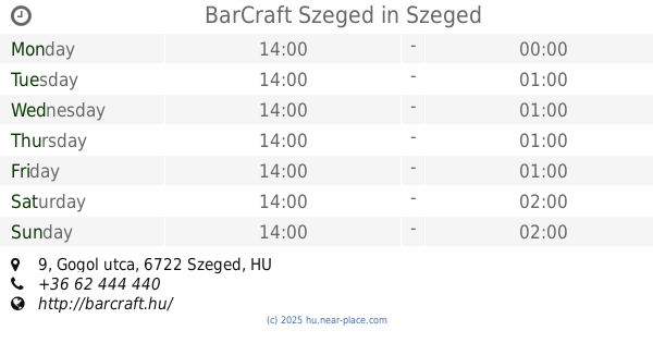
BarCraft Szeged
Szeged, Gogol utca 9
Bar
read more
1.199 km
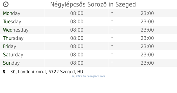
Négylépcsős Söröző
Szeged, Londoni körút 30
Bar
read more
1.266 km
Csöndes Kocsma
Szeged, Szabad Sajtó utca 7
Bar
read more
1.267 km
Cool club
Szeged, 22, Londoni körút
Bar
read more
📑
all categories
Accounting
Administrative area level 1
Administrative area level 2
Airport
Amusement park
Aquarium
Art gallery
Atm
Bakery
Bank
Bar
Beauty salon
Bicycle store
Book store
Bowling alley
Bus station
Cafe
Campground
Car dealer
Car rental
Car repair
Car wash
Casino
Cemetery
Church
City hall
Clothing store
Colloquial area
Convenience store
Country
Courthouse
Dentist
Department store
Doctor
Electrician
Electronics store
Embassy
Finance
Fire station
Florist
Food
Funeral home
Furniture store
Gas station
General contractor
Grocery or supermarket
Gym
Hair care
Hardware store
Health
Hindu Temple
Home goods store
Hospital
Insurance agency
Intersection
Jewelry store
Laundry
Lawyer
Library
Light rail station
Liquor store
Local government office
Locality
Locksmith
Lodging
Meal delivery
Meal takeaway
Mosque
Movie rental
Movie theater
Moving company
Museum
Natural feature
Neighborhood
Night club
Painter
Park
Parking
Pet store
Pharmacy
Physiotherapist
Place of worship
Plumber
Point of interest
Police
Political
Post office
Premise
Real estate agency
Restaurant
Roofing contractor
Route
Rv park, camping
School
Shoe store
Shopping mall
Spa
Stadium
Storage
Store
Subpremise
Subway station
Supermarket
Synagogue
Taxi stand
Train station
Transit station
Travel agency
University
Veterinary care
Zoo
administrative area level 3
sublocality level 1
↑