Bar nearby Exclusive Nympha Night Bar
Coronavirus disease (COVID-19) Situation
confirmed cases
2230232
deaths
49048
Hungary
Bar nearby Exclusive Nympha Night Bar
Exclusive Nympha Night Bar
Győr, Bácsai út 26 Magyarország
contacts phone
:
+36
Latitude:
47.6988791
, Longitude:
17.636736
read more
nearest Bar
857 m
Lúdláb presszó
Győr, Rónay Jácint utca 2
Bar
read more
868 m
Malibu Wellness Night Club
Győr, Ady Endre utca 2
Bar
read more
881 m
Mákvirág Gasztroklub
Győr, Ady Endre utca 16
Bar
read more
914 m
Elixir Bar n' Kitchen
Győr, Egyetem tér
Bar
read more
916 m
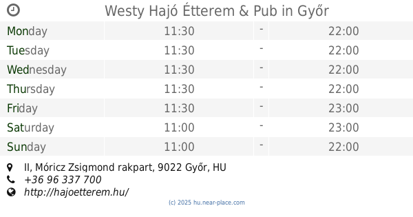
Westy Hajó Restaurant & Pub
Győr, hajó, Móricz Zsigmond rakpart II
Bar
read more
916 m
Westy Hajó Étterem & Pub
Győr, hajó, Móricz Zsigmond rakpart II
Bar
read more
1.153 km
Divino Györ
Győr, Hungary, Széchenyi tér 7
Bar
read more
1.18 km
Éjjeli Műszak Romkocsma
Győr, Liszt Ferenc utca 8
Bar
read more
1.231 km
Caffe Da Noi
Győr, Szabadsajtó utca 17
Bar
read more
1.267 km
BarBár - Győr
Győr, Schweidel utca 25
Bar
read more
1.274 km
Tango Bar
Győr, Baross Gábor út 5
Bar
read more
1.279 km
Bohém Tanya
Győr, Schweidel utca 21
Bar
read more
1.291 km
HRABAL SÖRÖZŐ
Győr, Czuczor Gergely utca 6
Bar
read more
1.291 km
Elixir Lounge
Győr, Czuzcor G. utca, 6
Bar
read more
1.299 km
Csillag EzPresszó
Győr, Csillag utca 6
Bar
read more
1.339 km
Conga
Győr, Kisfaludy utca 26
Bar
read more
1.355 km
Bar of Legends
Győr, Bécsi kapu tér 13
Bar
read more
1.414 km
Pirate Dance Club
Győr, Baross Gábor út 21
Bar
read more
1.598 km
Borka fröccsterasz
Győr, Zechmeister utca
Bar
read more
1.652 km
Iparoskör Söröző
Győr, Bisinger József sétány 18
Bar
read more
1.675 km
Burcsellás Vendéglő
Győr, Aradi vértanúk útja 20
Bar
read more
1.823 km
Győri Borház - Tokaji Borkereskedés
Győr, Bartók Béla út 1
Bar
read more
1.832 km
mini Brewery
Győr, Külső Bácsai út 14
Bar
read more
1.845 km
Borvirág Borozó
Győr, Nagysándor József utca 23
Bar
read more
1.996 km
Diána Pub
Győr, Kandó Kálmán utca 4
Bar
read more
📑
all categories
Accounting
Administrative area level 1
Administrative area level 2
Airport
Amusement park
Aquarium
Art gallery
Atm
Bakery
Bank
Bar
Beauty salon
Bicycle store
Book store
Bowling alley
Bus station
Cafe
Campground
Car dealer
Car rental
Car repair
Car wash
Casino
Cemetery
Church
City hall
Clothing store
Colloquial area
Convenience store
Country
Courthouse
Dentist
Department store
Doctor
Electrician
Electronics store
Embassy
Finance
Fire station
Florist
Food
Funeral home
Furniture store
Gas station
General contractor
Grocery or supermarket
Gym
Hair care
Hardware store
Health
Hindu Temple
Home goods store
Hospital
Insurance agency
Intersection
Jewelry store
Laundry
Lawyer
Library
Light rail station
Liquor store
Local government office
Locality
Locksmith
Lodging
Meal delivery
Meal takeaway
Mosque
Movie rental
Movie theater
Moving company
Museum
Natural feature
Neighborhood
Night club
Painter
Park
Parking
Pet store
Pharmacy
Physiotherapist
Place of worship
Plumber
Point of interest
Police
Political
Post office
Premise
Real estate agency
Restaurant
Roofing contractor
Route
Rv park, camping
School
Shoe store
Shopping mall
Spa
Stadium
Storage
Store
Subpremise
Subway station
Supermarket
Synagogue
Taxi stand
Train station
Transit station
Travel agency
University
Veterinary care
Zoo
administrative area level 3
sublocality level 1
↑