Bar nearby Csomi Kocsma
Hungary
Bar nearby Csomi Kocsma
Csomi Kocsma
14, Szent István tér, 6721, Szeged, HU Magyarország
contacts phone
:
+36
Latitude:
46.2579297
, Longitude:
20.1497387
larger map & directions
read more
nearest Bar
144 m
Vico Drink Bar
Szeged, Szent István tér 16
Bar
read more
233 m
2-es Klub
Szeged, Csongrádi sugárút 6
Bar
read more
373 m
Vedres Sörkert
Szeged, Horváth Mihály utca 2-6
Bar
read more
476 m
retro Club
Szeged, Széchenyi tér 3
Bar
read more
518 m
Napfény Műterem
Szeged, Széchenyi tér 2
Bar
read more
534 m
Zápor József kávézója
Szeged, Deák Ferenc utca 15
Bar
read more
537 m
Fülig Jimmy Pub
Szeged, József Attila sugárút 13
Bar
read more
545 m
Jeges Kocsma
Szeged, Tisza Lajos körút 53
Bar
read more
550 m
Szegedi Jégkunyhó Kft.
Szeged, Tisza Lajos körút 53
Bar
read more
583 m
Zátony
Szeged, Mikszáth Kálmán utca 13
Bar
read more
587 m
Zöld Tündér Abszint Bár és Kávézó
Szeged, Tisza Lajos körút 57
Bar
read more
613 m
Vár Söröző
Szeged, Vár utca 4
Bar
read more
639 m
Múzeum Lejtő, Zápor Kávézó
Szeged, Roosevelt tér 1-3
Bar
read more
703 m
Sárkány Pub
Szeged, Deák Ferenc utca 29
Bar
read more
752 m
HB Söröző
Szeged, Csongrádi sugárút 48
Bar
read more
776 m
Propeller söröző
Szeged, Kölcsey utca 6
Bar
read more
777 m
Laczkó Borozó
Szeged, Nádas utca 8
Bar
read more
786 m
Piano Pub
Szeged, Kölcsey utca 4
Bar
read more
804 m
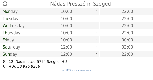
Nádas Presszó
Szeged, Nádas utca 12
Bar
read more
931 m
DTK&Pub
Szeged, Dugonics tér 11
Bar
read more
937 m
JATE klub
Szeged, Dugonics tér 13
Bar
read more
966 m
Kálvária Bár
Szeged, Kálvária sugárút 10
Bar
read more
986 m
Cool club
Szeged, 22, Londoni körút
Bar
read more
1.103 km
Rózsafa Söröző
Szeged, József Attila sugárút 90
Bar
read more
1.265 km
Kishordó
Szeged, Damjanich utca 2
Bar
read more
📑
all categories
Accounting
Administrative area level 1
Administrative area level 2
Airport
Amusement park
Aquarium
Art gallery
Atm
Bakery
Bank
Bar
Beauty salon
Bicycle store
Book store
Bowling alley
Bus station
Cafe
Campground
Car dealer
Car rental
Car repair
Car wash
Casino
Cemetery
Church
City hall
Clothing store
Colloquial area
Convenience store
Country
Courthouse
Dentist
Department store
Doctor
Electrician
Electronics store
Embassy
Finance
Fire station
Florist
Food
Funeral home
Furniture store
Gas station
General contractor
Grocery or supermarket
Gym
Hair care
Hardware store
Health
Hindu Temple
Home goods store
Hospital
Insurance agency
Intersection
Jewelry store
Laundry
Lawyer
Library
Light rail station
Liquor store
Local government office
Locality
Locksmith
Lodging
Meal delivery
Meal takeaway
Mosque
Movie rental
Movie theater
Moving company
Museum
Natural feature
Neighborhood
Night club
Painter
Park
Parking
Pet store
Pharmacy
Physiotherapist
Place of worship
Plumber
Point of interest
Police
Political
Post office
Premise
Real estate agency
Restaurant
Roofing contractor
Route
Rv park, camping
School
Shoe store
Shopping mall
Spa
Stadium
Storage
Store
Subpremise
Subway station
Supermarket
Synagogue
Taxi stand
Train station
Transit station
Travel agency
University
Veterinary care
Zoo
administrative area level 3
sublocality level 1
↑