Bank nearby FHB Bank
Hungary
Bank nearby FHB Bank
FHB Bank
Veszprém, Cserhát lakótelep 7 Ungarn
contacts phone
:
+36
Latitude:
47.0935757
, Longitude:
17.910003
read more
nearest Bank
68 m
K&H bankfiók és ATM
Veszprém, Kossuth Lajos utca 6
Bank
read more
72 m
K & H branch and ATM - Cserhat housing
Veszprém, Cserhát lakótelep
Bank
read more
72 m
K&H fiók és ATM - Cserhát lakótelep
Veszprém, Cserhát lakótelep
Bank
read more
107 m
Zírci Takarék Fiók
Veszprém, Kossuth Lajos utca 4
Bank
read more
180 m
Sopron Bank Zrt. - Veszprémi fiók
Veszprém, Szabadság tér 8
Bank
read more
182 m
EXIM Képviselet
Veszprém, Szabadság tér 7
Bank
read more
182 m
EXIM Agency
Veszprém, Szabadság tér 7
Bank
read more
191 m
OTP Bank
Veszprém, 8200, Brusznyai Árpád utca 1
Bank
read more
204 m
Raiffeisen Bank
Veszprém, Mindszenty József u. 2., (korábban: Budapest út 4.)
Bank
read more
204 m
OTP Bank
Veszprém, Budapest út 4
Bank
read more
223 m
OTP Bank
Veszprém, Brusznyai Árpád utca 1
Bank
read more
227 m
Raiffeisen Bank Zrt.
Veszprém, Budapest út 4
Bank
read more
242 m
Kinizsi Bank Zrt.
Veszprém, Óváros tér 22
Bank
read more
247 m
Budapest Bank
Veszprém, Mindszenty József u. 7
Bank
read more
247 m
Budapest Bank - Veszprémi Fiók
Veszprém, Mindszenty József u. 7
Bank
read more
259 m
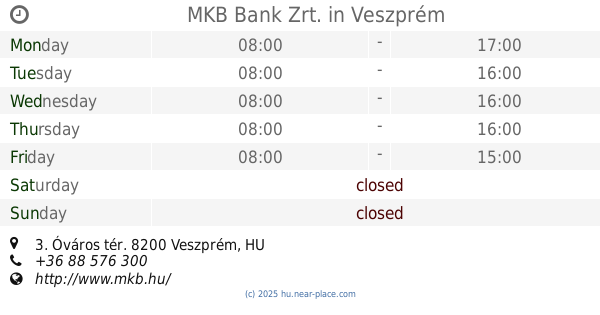
MKB Bank Zrt.
Veszprém, Óváros tér 3
Bank
read more
276 m
Magyar Külkereskedelmi Bank Nyrt.
Veszprém, Óváros tér 3
Bank
read more
279 m
MKB Zrt.
Veszprém, 8200, Óváros tér 3
Bank
read more
291 m
Veszprém Megyei Vállalkozásfejlesztési Alapítvány
Veszprém, Szeglethy József utca 1
Bank
read more
292 m
CIB Bank Veszprém
Veszprém, Szeglethy József utca 1
Bank
read more
343 m
Erste Bank fiók
Veszprém, Ádám Iván utca 2
Bank
read more
462 m
UniCredit Bank
Veszprém, Ady E. u. 1.
Bank
read more
525 m
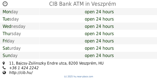
CIB Bank ATM
Veszprém, Bajcsy-Zsilinszky Endre utca 11
Bank
read more
526 m
B3 Takarékszövetkezet
Veszprém, fsz. B. ép. 5., Ady Endre utca 7
Bank
read more
873 m
B3 Takarékszövetkezet
Veszprém, Egyetem utca 19
Bank
read more
📑
all categories
Accounting
Administrative area level 1
Administrative area level 2
Airport
Amusement park
Aquarium
Art gallery
Atm
Bakery
Bank
Bar
Beauty salon
Bicycle store
Book store
Bowling alley
Bus station
Cafe
Campground
Car dealer
Car rental
Car repair
Car wash
Casino
Cemetery
Church
City hall
Clothing store
Colloquial area
Convenience store
Country
Courthouse
Dentist
Department store
Doctor
Electrician
Electronics store
Embassy
Finance
Fire station
Florist
Food
Funeral home
Furniture store
Gas station
General contractor
Grocery or supermarket
Gym
Hair care
Hardware store
Health
Hindu Temple
Home goods store
Hospital
Insurance agency
Intersection
Jewelry store
Laundry
Lawyer
Library
Light rail station
Liquor store
Local government office
Locality
Locksmith
Lodging
Meal delivery
Meal takeaway
Mosque
Movie rental
Movie theater
Moving company
Museum
Natural feature
Neighborhood
Night club
Painter
Park
Parking
Pet store
Pharmacy
Physiotherapist
Place of worship
Plumber
Point of interest
Police
Political
Post office
Premise
Real estate agency
Restaurant
Roofing contractor
Route
Rv park, camping
School
Shoe store
Shopping mall
Spa
Stadium
Storage
Store
Subpremise
Subway station
Supermarket
Synagogue
Taxi stand
Train station
Transit station
Travel agency
University
Veterinary care
Zoo
administrative area level 3
sublocality level 1
↑