places in Balmazújváros
Coronavirus disease (COVID-19) Situation
confirmed cases
2230232
deaths
49048
Hungary
Balmazújváros
Balmazújváros
Administrative Region:
Hajdu-Bihar
population:
17 026
calling code:
+36-52
postcode:
4060
Location on the map of Hungary
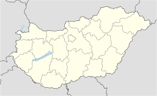
Balmazújváros
Bus station
Balmazújváros, Nagyhort, Állami Gazdaság
Hungary
Bus station
read more
Balmazújváros, vasútállomás
Hungary
Bus station
read more
Balmazújváros, Kishortobágyi Csárda
Hungary
Bus station
read more
Balmazújváros, Andrásháza
Hungary
Bus station
read more
Balmazújváros, temető
Hungary
Bus station
read more
Balmazújváros, Nagyhát,bejárati út
Hungary
Bus station
read more
Balmazújváros, Veres Péter utca
Hungary
Bus station
read more
Balmazújváros, Böszörményi utca
Hungary
Bus station
read more
Balmazújváros, vegyesbolt
Hungary
Bus station
read more
Balmazújváros, Tiszacsegei utca 11.
Hungary
Bus station
read more
Balmazújváros, Debreceni utca
Hungary
Bus station
read more
Balmazújváros, Tüzép-telep
Hungary
Bus station
read more
Balmazújváros, MGM
Hungary
Bus station
read more
Balmazújváros, Sertéskombinát
Hungary
Bus station
read more
Balmazújváros, Kossuth tér
Hungary
Bus station
read more
Autóbuszállomás Balmazújváros
Balmazújváros, Nádudvari utca, Autóbuszállomás
Bus station
read more
Balmazújváros, autóbusz-forduló
Hungary
Bus station
read more
Balmazújváros, Nádudvari út 15
Hungary
Bus station
read more
Balmazújváros, Telekföld
Hungary
Bus station
read more
Electronics store
Compact 2000 Bt.
Balmazújváros, Árpád utca 3
Electronics store
read more
Park
Városi sporttelep
Balmazújváros
Park
read more
Police
Balmazújvárosi Rendőrkapitányság
Balmazújváros, Debreceni utca 4.
Police
read more
Rendőrség
Balmazújváros, Debreceni utca 4
Police
read more
Restaurant
Kerekes Panzió és Étterem
Balmazújváros, Veres Péter utca 4
Restaurant
read more
Kastélykert Söröző
Balmazújváros, Kastélykert utca 6
Restaurant
read more
Virágoskúti Rózsakert Biocsárda
Balmazújváros, Hrsz.:0461 30
Restaurant
read more
📑
Balmazújváros all categories
Accounting
Atm
Bakery
Bank
Bar
Beauty salon
Bicycle store
Bus station
Cafe
Car repair
Cemetery
Church
City hall
Clothing store
Doctor
Electronics store
Fire station
Florist
Food
Furniture store
Gas station
General contractor
Grocery or supermarket
Gym
Health
Home goods store
Hospital
Insurance agency
Library
Locality
Lodging
Museum
Natural feature
Night club
Park
Pharmacy
Point of interest
Police
Post office
Premise
Restaurant
Roofing contractor
Route
School
Shopping mall
Spa
Stadium
Store
Supermarket
Train station
Transit station
Travel agency
Veterinary care
sublocality level 1
↑