Bakery nearby Venoli Pékáru Kft.
Hungary
Bakery nearby Venoli Pékáru Kft.
Venoli Pékáru Kft.
Győr, Fehérvári út 80 Magyarország
contacts phone
:
+36
Latitude:
47.6746281
, Longitude:
17.669369
read more
nearest Bakery
1.11 km
Toni Pékség
Győr, Kodály Zoltán utca 2
Bakery
read more
1.141 km
Pedro Bakery
Győr, Jereváni út 32
Bakery
read more
1.141 km
Pedró Pékség
Győr, Jereváni út 32
Bakery
read more
1.162 km
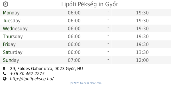
Lipóti Pékség
Győr, Jereváni út 25
Bakery
read more
1.171 km
Lipóti pékség és kávézó
Győr, Jereváni út 25
Bakery
read more
1.212 km
Lipóti pékség és kávézó
Győr, Kodály Zoltán utca 41
Bakery
read more
1.213 km
Lipóti Pékség
Győr, Földes Gábor utca 29
Bakery
read more
1.26 km
Öcsi Cukrászda
Győr, Konini út 17
Bakery
read more
1.265 km
Kis Pékség
Győr, Kodály Zoltán utca 49
Bakery
read more
1.381 km
Pedró Pékség
Győr, Tihanyi Árpád út 77
Bakery
read more
1.775 km
Pedro Bakery
Győr, Vágóhíd utca
Bakery
read more
1.775 km
Pedró Pékség
Győr, Vágóhíd utca
Bakery
read more
1.808 km
Harnyas Pékség
Győr, Szent Imre út 62
Bakery
read more
1.844 km
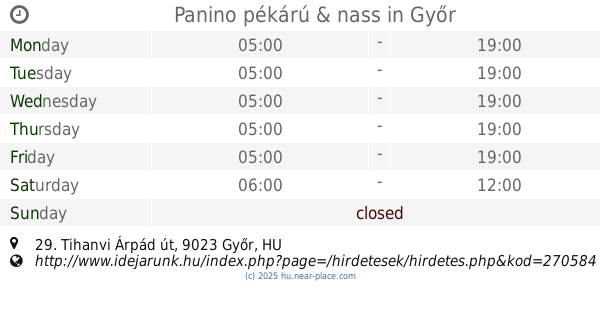
Panino pékárú & nass
Győr, Tihanyi Árpád út 29
Bakery
read more
1.872 km
Pedró Pékség
Győr, Herman Ottó utca 25
Bakery
read more
1.932 km
Pedró Pékség
Győr, Szent Imre út 128
Bakery
read more
1.932 km
Pedro Bakery
Győr, Szent Imre út 128
Bakery
read more
1.938 km
Harnyas Pékség
Győr, Szent Imre út 8
Bakery
read more
1.962 km
Európa Pékség
Győr, Tihanyi Árpád út 21
Bakery
read more
1.964 km
Angel Bakery and Confectionery
Győr, Tihanyi Árpád út 23
Bakery
read more
2.165 km
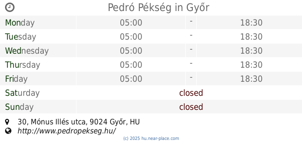
Pedró Pékség
Győr, Mónus Illés utca 30
Bakery
read more
2.399 km
Arany Cipó Pékség
Győr, Budai út 1
Bakery
read more
2.746 km
Pedro Bakery
Győr, Kiss János utca 18
Bakery
read more
2.856 km
Harnyas pékség
Győr, Borsos Miklós utca 17
Bakery
read more
3.024 km
Gluténmentes Élelmiszer
Győr, Bajcsy-Zsilinszky út
Bakery
read more
📑
all categories
Accounting
Administrative area level 1
Administrative area level 2
Airport
Amusement park
Aquarium
Art gallery
Atm
Bakery
Bank
Bar
Beauty salon
Bicycle store
Book store
Bowling alley
Bus station
Cafe
Campground
Car dealer
Car rental
Car repair
Car wash
Casino
Cemetery
Church
City hall
Clothing store
Colloquial area
Convenience store
Country
Courthouse
Dentist
Department store
Doctor
Electrician
Electronics store
Embassy
Finance
Fire station
Florist
Food
Funeral home
Furniture store
Gas station
General contractor
Grocery or supermarket
Gym
Hair care
Hardware store
Health
Hindu Temple
Home goods store
Hospital
Insurance agency
Intersection
Jewelry store
Laundry
Lawyer
Library
Light rail station
Liquor store
Local government office
Locality
Locksmith
Lodging
Meal delivery
Meal takeaway
Mosque
Movie rental
Movie theater
Moving company
Museum
Natural feature
Neighborhood
Night club
Painter
Park
Parking
Pet store
Pharmacy
Physiotherapist
Place of worship
Plumber
Point of interest
Police
Political
Post office
Premise
Real estate agency
Restaurant
Roofing contractor
Route
Rv park, camping
School
Shoe store
Shopping mall
Spa
Stadium
Storage
Store
Subpremise
Subway station
Supermarket
Synagogue
Taxi stand
Train station
Transit station
Travel agency
University
Veterinary care
Zoo
administrative area level 3
sublocality level 1
↑