Bakery nearby Mlinar
Hungary
Bakery nearby Mlinar
Mlinar
7, Madách Imre tér, 1075, Budapest, HU Magyarország
contacts phone
:
+36 23 799 101
website:
www.mlinar.hr
Latitude:
47.4971728
, Longitude:
19.0565358
larger map & directions
read more
nearest Bakery
194 m
Lipóti pékség
Budapest, Bajcsy-Zsilinszky út 5
Bakery
read more
209 m
Bögre pékség és kávézó
Budapest, Madách Imre út 11
Bakery
read more
371 m
The Sweet
Budapest, 1074, Dob utca 21
Bakery
read more
391 m
Mlinar
Budapest, Petőfi Sándor utca 10
Bakery
read more
395 m
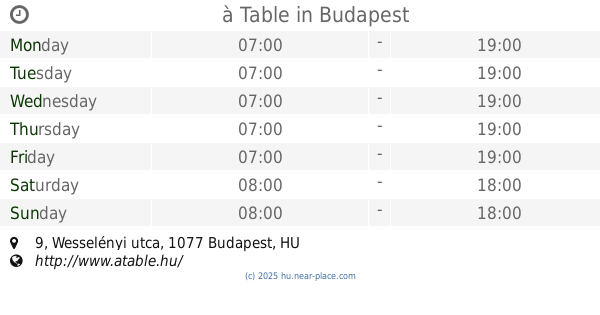
à Table
Budapest, Wesselényi utca 9
Bakery
read more
434 m
Lipóti Pékség És Kávézó Astoria
Budapest, Rákóczi út 6
Bakery
read more
445 m
Szamos Marcipán Cukrászda
Budapest, Párizsi utca 3
Bakery
read more
525 m
Anyu Premium Streetfood
Budapest, Dohány utca 22
Bakery
read more
547 m
Jacques Liszt
Budapest, Apáczai Csere János utca 7
Bakery
read more
667 m
Stephen Confectionery
Budapest, Október 6. utca 17
Bakery
read more
678 m
Francia Pékség Mintaboltja
Budapest, Dob utca 46b
Bakery
read more
684 m
Art Cukrászda
Budapest, Wesselényi utca 30
Bakery
read more
698 m
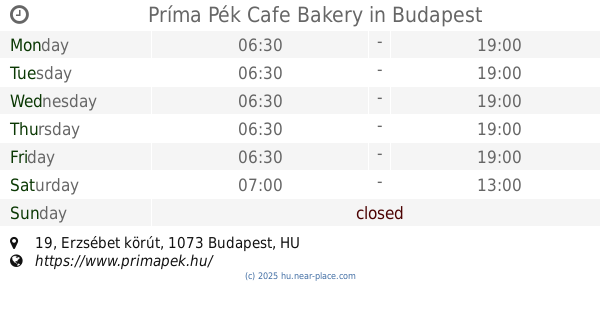
Príma Pék Cafe & Bakery
Budapest, Klauzál tér 12
Bakery
read more
739 m
Friss Pékség
Budapest, Bajcsy-Zsilinszky út 34
Bakery
read more
800 m
The Bake Shop
Budapest, Klauzál utca 11
Bakery
read more
822 m
Kiskovász Kézműves Pékség
Budapest, Nagymező utca 36
Bakery
read more
836 m
BITE Bakery Café
Budapest, Király utca 59
Bakery
read more
886 m
Strudel Hugó
Budapest, Kertész utca 22
Bakery
read more
894 m
Lipóti Pékség
Budapest, Király utca 59b
Bakery
read more
900 m
Panificio il Basilico
Budapest, Hold utca 13
Bakery
read more
972 m
Lipóti Pékség
Budapest, Blaha Lujza tér 1
Bakery
read more
980 m
Budapest Cukrászda
Budapest, Bródy Sándor utca 23/a
Bakery
read more
1.017 km
Príma Pék Cafe Bakery
Budapest, Erzsébet körút 19
Bakery
read more
1.054 km
Fornetti Food G Beverage
Budapest, Oktogon 3
Bakery
read more
1.068 km
Budapest Bakery & Cafe
Budapest, Üllői út 9
Bakery
read more
📑
all categories
Accounting
Administrative area level 1
Administrative area level 2
Airport
Amusement park
Aquarium
Art gallery
Atm
Bakery
Bank
Bar
Beauty salon
Bicycle store
Book store
Bowling alley
Bus station
Cafe
Campground
Car dealer
Car rental
Car repair
Car wash
Casino
Cemetery
Church
City hall
Clothing store
Colloquial area
Convenience store
Country
Courthouse
Dentist
Department store
Doctor
Electrician
Electronics store
Embassy
Finance
Fire station
Florist
Food
Funeral home
Furniture store
Gas station
General contractor
Grocery or supermarket
Gym
Hair care
Hardware store
Health
Hindu Temple
Home goods store
Hospital
Insurance agency
Intersection
Jewelry store
Laundry
Lawyer
Library
Light rail station
Liquor store
Local government office
Locality
Locksmith
Lodging
Meal delivery
Meal takeaway
Mosque
Movie rental
Movie theater
Moving company
Museum
Natural feature
Neighborhood
Night club
Painter
Park
Parking
Pet store
Pharmacy
Physiotherapist
Place of worship
Plumber
Point of interest
Police
Political
Post office
Premise
Real estate agency
Restaurant
Roofing contractor
Route
Rv park, camping
School
Shoe store
Shopping mall
Spa
Stadium
Storage
Store
Subpremise
Subway station
Supermarket
Synagogue
Taxi stand
Train station
Transit station
Travel agency
University
Veterinary care
Zoo
administrative area level 3
sublocality level 1
↑