Bakery nearby Lipóti Pékség
Coronavirus disease (COVID-19) Situation
confirmed cases
2230232
deaths
49048
Hungary
Bakery nearby Lipóti Pékség
Lipóti Pékség
Győr, 9021, Arany János utca 31 Magyarország
contacts phone
:
+36
Latitude:
47.6867918
, Longitude:
17.6341685
read more
nearest Bakery
137 m
Fornetti Food & Beverages
Győr, Baross Gábor út 26
Bakery
read more
183 m
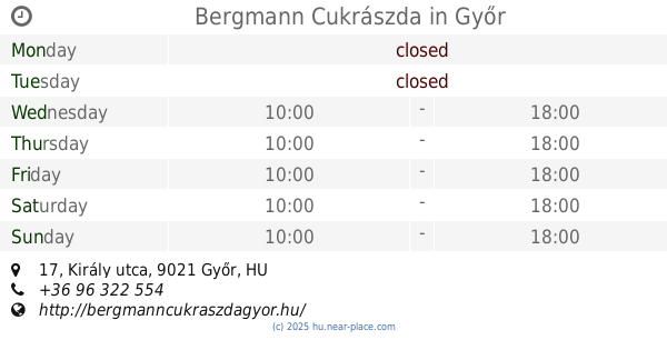
Bergmann Cukrászda
Győr, Király utca 17
Bakery
read more
184 m
PaleoZóna
Győr, Czuczor Gergely utca 15
Bakery
read more
232 m
Toni Pékség
Győr, Bajcsy-Zsilinszky út 32
Bakery
read more
272 m
Cserpes Tejbolt
Győr, Bajcsy-Zsilinszky út 43
Bakery
read more
290 m
Gluténmentes Élelmiszer
Győr, Bajcsy-Zsilinszky út
Bakery
read more
311 m
Kenyerecske Boltocska
Győr, Jedlik Ányos utca 8
Bakery
read more
339 m
Lipóti Pékség
Győr, 9021, Aradi vértanúk útja 22
Bakery
read more
442 m
Lipóti Pékség
Győr, Jókai utca 13-17
Bakery
read more
536 m
Pedro Bakery
Győr, Kiss János utca 18
Bakery
read more
536 m
Pedró Pékség
Győr, Kiss János utca 18
Bakery
read more
617 m
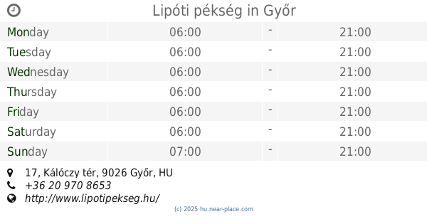
Lipóti pékség
Győr, Kálóczy tér 17
Bakery
read more
748 m
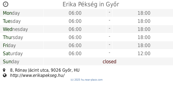
Erika Pékség
Győr, Rónay Jácint utca 8
Bakery
read more
790 m
Máz Cukrászda
Töltésszer, Győr
Bakery
read more
830 m
Szonyita Csemege
Győr, Zrínyi utca 14
Bakery
read more
832 m
Calvary Confectionery
Győr, Kálvária utca 2/b
Bakery
read more
832 m
Kálvária Cukrászda
Győr, Kálvária utca 2/b
Bakery
read more
925 m
Arany Cipó Pékség
Győr, Budai út 1
Bakery
read more
1.048 km
Angel Bakery and Confectionery
Győr, Tihanyi Árpád út 23
Bakery
read more
1.051 km
Európa Pékség
Győr, Tihanyi Árpád út 21
Bakery
read more
1.205 km
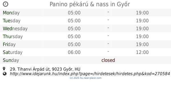
Panino pékárú & nass
Győr, Tihanyi Árpád út 29
Bakery
read more
1.302 km
Pedró Pékség
Győr, Herman Ottó utca 25
Bakery
read more
1.737 km
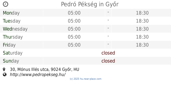
Pedró Pékség
Győr, Mónus Illés utca 30
Bakery
read more
1.765 km
Erika Pékség és Cukrászat
Győr, Kossuth Lajos utca 154
Bakery
read more
1.894 km
Lipóti pékség és kávézó
Győr, Kodály Zoltán utca 41
Bakery
read more
📑
all categories
Accounting
Administrative area level 1
Administrative area level 2
Airport
Amusement park
Aquarium
Art gallery
Atm
Bakery
Bank
Bar
Beauty salon
Bicycle store
Book store
Bowling alley
Bus station
Cafe
Campground
Car dealer
Car rental
Car repair
Car wash
Casino
Cemetery
Church
City hall
Clothing store
Colloquial area
Convenience store
Country
Courthouse
Dentist
Department store
Doctor
Electrician
Electronics store
Embassy
Finance
Fire station
Florist
Food
Funeral home
Furniture store
Gas station
General contractor
Grocery or supermarket
Gym
Hair care
Hardware store
Health
Hindu Temple
Home goods store
Hospital
Insurance agency
Intersection
Jewelry store
Laundry
Lawyer
Library
Light rail station
Liquor store
Local government office
Locality
Locksmith
Lodging
Meal delivery
Meal takeaway
Mosque
Movie rental
Movie theater
Moving company
Museum
Natural feature
Neighborhood
Night club
Painter
Park
Parking
Pet store
Pharmacy
Physiotherapist
Place of worship
Plumber
Point of interest
Police
Political
Post office
Premise
Real estate agency
Restaurant
Roofing contractor
Route
Rv park, camping
School
Shoe store
Shopping mall
Spa
Stadium
Storage
Store
Subpremise
Subway station
Supermarket
Synagogue
Taxi stand
Train station
Transit station
Travel agency
University
Veterinary care
Zoo
administrative area level 3
sublocality level 1
↑