Bakery nearby Füredi Pékség & Pizzéria
Hungary
Bakery nearby Füredi Pékség & Pizzéria
Füredi Pékség & Pizzéria
Füredi út, 4027, Debrecen, HU Magyarország
contacts phone
:
+36
Latitude:
47.5416102
, Longitude:
21.6125858
larger map & directions
read more
nearest Bakery
31 m
Lejla Pékség
Debrecen, Füredi út 54
Bakery
read more
138 m
Balmaz-Sütöde Kft. Pékáru
Debrecen, Sinai Miklós utca 21
Bakery
read more
407 m
PÉKHÁZ Mintabolt
Debrecen, Nádor utca 5
Bakery
read more
743 m
Balmaz - Sütöde Kft. Pékáru
Debrecen, Ibolya utca 4
Bakery
read more
809 m
Pékáru bolt
Debrecen, Nagy Lajos király tér 5
Bakery
read more
918 m
Bogi Kedvence Pékség
Debrecen, Bem tér 11
Bakery
read more
995 m
Lejla Bakery
Debrecen, Darabos utca 18
Bakery
read more
995 m
Lejla Pékség
Debrecen, Darabos utca 18
Bakery
read more
1.026 km
Kiscipó Pékség
Debrecen, 53, Poroszlay út 51
Bakery
read more
1.038 km
Glulu's FreeFrom termékek mintaboltja (I-Bolt)
Debrecen, Böszörményi út 138
Bakery
read more
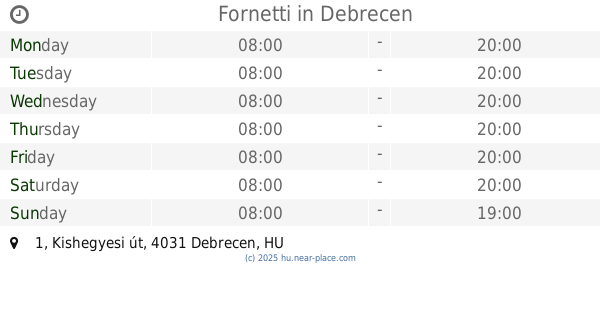
1.187 km
Fornetti
Debrecen, Kishegyesi út 1
Bakery
read more
1.198 km
Fornetti
Debrecen, Péterfia utca 20
Bakery
read more
1.348 km
PÉKHÁZ Mintabolt
Debrecen, Hatvan utca 12-14
Bakery
read more
1.409 km
Balmaz Sütöde
Debrecen, Segner János tér 7/A
Bakery
read more
1.48 km
PÉKHÁZ Mintabolt
Debrecen, Vár utca 3
Bakery
read more
1.594 km
French Bakery
Debrecen, Csapó utca 15
Bakery
read more
1.602 km
Rétesbolt
Debrecen, Piac utca 23
Bakery
read more
1.668 km
Magyar Pék Bolt
Debrecen, Doberdó utca
Bakery
read more
1.725 km
Diti Bakery
Debrecen, Csapó utca 64
Bakery
read more
1.725 km
DITI Pékség
Debrecen, Csapó utca 64
Bakery
read more
1.749 km
PÉKHÁZ Mintabolt
Debrecen, Széchenyi utca 52-56
Bakery
read more
1.809 km
Verona bakery
Debrecen, Batthyány utca 2
Bakery
read more
1.854 km
Pékáru Balmaz Sütöde Kft.
Debrecen, Csapó utca 90
Bakery
read more
1.995 km
PÉKHÁZ Mintabolt
Debrecen, Szent Anna utca 10-12
Bakery
read more
2.357 km
Kiscipó Pékség
Debrecen, Sumen utca 18
Bakery
read more
📑
all categories
Accounting
Administrative area level 1
Administrative area level 2
Airport
Amusement park
Aquarium
Art gallery
Atm
Bakery
Bank
Bar
Beauty salon
Bicycle store
Book store
Bowling alley
Bus station
Cafe
Campground
Car dealer
Car rental
Car repair
Car wash
Casino
Cemetery
Church
City hall
Clothing store
Colloquial area
Convenience store
Country
Courthouse
Dentist
Department store
Doctor
Electrician
Electronics store
Embassy
Finance
Fire station
Florist
Food
Funeral home
Furniture store
Gas station
General contractor
Grocery or supermarket
Gym
Hair care
Hardware store
Health
Hindu Temple
Home goods store
Hospital
Insurance agency
Intersection
Jewelry store
Laundry
Lawyer
Library
Light rail station
Liquor store
Local government office
Locality
Locksmith
Lodging
Meal delivery
Meal takeaway
Mosque
Movie rental
Movie theater
Moving company
Museum
Natural feature
Neighborhood
Night club
Painter
Park
Parking
Pet store
Pharmacy
Physiotherapist
Place of worship
Plumber
Point of interest
Police
Political
Post office
Premise
Real estate agency
Restaurant
Roofing contractor
Route
Rv park, camping
School
Shoe store
Shopping mall
Spa
Stadium
Storage
Store
Subpremise
Subway station
Supermarket
Synagogue
Taxi stand
Train station
Transit station
Travel agency
University
Veterinary care
Zoo
administrative area level 3
sublocality level 1
↑