Bakery nearby Fornetti
Hungary
Bakery nearby Fornetti
Fornetti
87, József körút, 1085, Budapest, HU Magyarország
contacts phone
:
+36
website:
fornetti.hu
Latitude:
47.4862504
, Longitude:
19.0698051
larger map & directions
read more
nearest Bakery
166 m
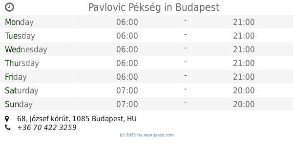
Pavlovic Pékség
Budapest, József körút 68
Bakery
read more
206 m
Látványpékség
Budapest, Tűzoltó utca 4
Bakery
read more
405 m
Hoppácska
Budapest, Ráday utca 33
Bakery
read more
416 m
Lipóti Pékség
Budapest, Harminckettesek tere 6
Bakery
read more
456 m
Félegyházi Pékség
Budapest, Tompa utca 15b
Bakery
read more
466 m
Mlinar Caffe
Budapest, Ferenc körút 13
Bakery
read more
490 m
Kézműves Perecezde
Budapest, Ferenc körút 10
Bakery
read more
495 m
Manioka gluténmentes pékség
Budapest, Ráday utca 15
Bakery
read more
521 m
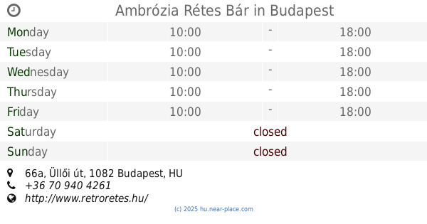
Ambrózia Rétes Bár
Budapest, Üllői út 66a
Bakery
read more
557 m
Budapest Bakery & Cafe
Budapest, Üllői út 9
Bakery
read more
579 m
Butter Brothers
Budapest, Lónyay utca 22
Bakery
read more
638 m
Lipóti pékség
Budapest, Mester utca 24
Bakery
read more
664 m
Flórián Pékség
Budapest, Baross utca 77
Bakery
read more
733 m
Eat Me Cake Boutique
Budapest, Berzenczey utca 5
Bakery
read more
735 m
Stefánia Pékség és Élelmiszer
Budapest, Mester utca 15
Bakery
read more
759 m
Budapest Cukrászda
Budapest, Bródy Sándor utca 23/a
Bakery
read more
777 m
Lipóldi Pékség
Budapest, Rákóczi tér 7-9
Bakery
read more
795 m
Finom Francia Pékáru Kft.
Budapest, Baross utca 87/a
Bakery
read more
851 m
Pogácsarendelés
Budapest, Baross utca 96
Bakery
read more
852 m
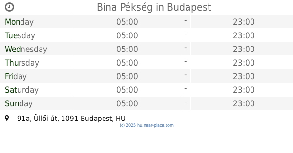
Bina Pékség
Budapest, Üllői út 91a
Bakery
read more
866 m
Friss Pékség
Budapest, Vámház körút 4
Bakery
read more
868 m
Tina Pékség
Budapest, Mester utca 40
Bakery
read more
1.15 km
Lipóti Pékség És Kávézó Astoria
Budapest, Rákóczi út 6
Bakery
read more
1.234 km
Flórián Adrián Pékség és Cukrászda
Budapest, Teleki László tér 3
Bakery
read more
1.257 km
Soroksári Buci Pékség
Budapest, Teleki László tér 2
Bakery
read more
📑
all categories
Accounting
Administrative area level 1
Administrative area level 2
Airport
Amusement park
Aquarium
Art gallery
Atm
Bakery
Bank
Bar
Beauty salon
Bicycle store
Book store
Bowling alley
Bus station
Cafe
Campground
Car dealer
Car rental
Car repair
Car wash
Casino
Cemetery
Church
City hall
Clothing store
Colloquial area
Convenience store
Country
Courthouse
Dentist
Department store
Doctor
Electrician
Electronics store
Embassy
Finance
Fire station
Florist
Food
Funeral home
Furniture store
Gas station
General contractor
Grocery or supermarket
Gym
Hair care
Hardware store
Health
Hindu Temple
Home goods store
Hospital
Insurance agency
Intersection
Jewelry store
Laundry
Lawyer
Library
Light rail station
Liquor store
Local government office
Locality
Locksmith
Lodging
Meal delivery
Meal takeaway
Mosque
Movie rental
Movie theater
Moving company
Museum
Natural feature
Neighborhood
Night club
Painter
Park
Parking
Pet store
Pharmacy
Physiotherapist
Place of worship
Plumber
Point of interest
Police
Political
Post office
Premise
Real estate agency
Restaurant
Roofing contractor
Route
Rv park, camping
School
Shoe store
Shopping mall
Spa
Stadium
Storage
Store
Subpremise
Subway station
Supermarket
Synagogue
Taxi stand
Train station
Transit station
Travel agency
University
Veterinary care
Zoo
administrative area level 3
sublocality level 1
↑