Supermarket nearby TESCO
Coronavirus disease (COVID-19) Situation
confirmed cases
2230232
deaths
49048
Hungary
Supermarket nearby TESCO
TESCO
Tata, Ring utca 1 Magyarország
contacts phone
:
+36
Latitude:
47.6288098
, Longitude:
18.3127891
read more
nearest Supermarket
1.802 km
SPAR Szupermarket
Tata, Rákóczi Ferenc utca 9
Supermarket
read more
2.203 km
Penny Market
Tata, Keszthelyi u. 1440/9 hrsz.
Supermarket
read more
2.482 km
SPAR Szupermarket
Tata, Május 1. út
Supermarket
read more
2.602 km
SPAR Szupermarket
Tata, Ady Endre utca 20
Supermarket
read more
5.995 km
SPAR Szupermarket
Tatabánya, Szent György utca 48
Supermarket
read more
6.919 km
Lidl
Tatabánya, Győri út 31
Supermarket
read more
7.164 km
SPAR
Tatabánya, Győri út 25
Supermarket
read more
7.413 km
Mini ABC
Kocs, Kossuth Lajos utca 49
Supermarket
read more
7.488 km
Goods Market
Tatabánya, Komáromi utca 22
Supermarket
read more
7.691 km
One Euro Market
Tatabánya, Réti utca 38
Supermarket
read more
7.829 km
Gondos Gazdik Boltja
Tatabánya, Dózsakert utca 53
Supermarket
read more
7.845 km
Coop
Kocs, Kis utca 4
Supermarket
read more
7.963 km
Euro Family
Tatabánya, Erdész utca 1
Supermarket
read more
8.011 km
SPAR Szupermarket
Tatabánya, Dózsa György út 28
Supermarket
read more
8.037 km
SPAR Szupermarket
Tatabánya, Fő tér 10
Supermarket
read more
8.527 km
Tesco
Tatabánya, 1/f, Köztársaság u
Supermarket
read more
10.278 km
Penny Market
Tatabánya, Ságvári Endre út 44
Supermarket
read more
10.558 km
ALDI
Tatabánya, Szent Borbála tér 35
Supermarket
read more
10.651 km
SPAR Szupermarket
Tatabánya, Szent Borbála út 33
Supermarket
read more
10.79 km
Lidl
Tatabánya, Szent Borbála út 31
Supermarket
read more
14.807 km
TESCO Oroszlány Hipermarket
Oroszlány, Környei út 3-5
Supermarket
read more
17.796 km
Lidl
Komárom, Mártírok útja 80
Supermarket
read more
17.796 km
Lidl Áruház
Komárom, Mártírok útja 80
Supermarket
read more
18.664 km
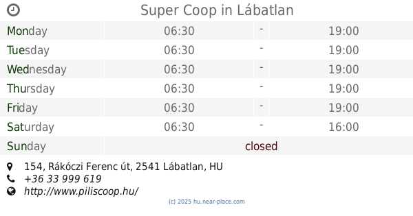
Super Coop
Lábatlan, Rákóczi Ferenc út 154
Supermarket
read more
19.274 km
SPAR Szupermarket
Komárom, Igmándi út 41
Supermarket
read more
📑
all categories
Accounting
Administrative area level 1
Administrative area level 2
Airport
Amusement park
Aquarium
Art gallery
Atm
Bakery
Bank
Bar
Beauty salon
Bicycle store
Book store
Bowling alley
Bus station
Cafe
Campground
Car dealer
Car rental
Car repair
Car wash
Casino
Cemetery
Church
City hall
Clothing store
Colloquial area
Convenience store
Country
Courthouse
Dentist
Department store
Doctor
Electrician
Electronics store
Embassy
Finance
Fire station
Florist
Food
Funeral home
Furniture store
Gas station
General contractor
Grocery or supermarket
Gym
Hair care
Hardware store
Health
Hindu Temple
Home goods store
Hospital
Insurance agency
Intersection
Jewelry store
Laundry
Lawyer
Library
Light rail station
Liquor store
Local government office
Locality
Locksmith
Lodging
Meal delivery
Meal takeaway
Mosque
Movie rental
Movie theater
Moving company
Museum
Natural feature
Neighborhood
Night club
Painter
Park
Parking
Pet store
Pharmacy
Physiotherapist
Place of worship
Plumber
Point of interest
Police
Political
Post office
Premise
Real estate agency
Restaurant
Roofing contractor
Route
Rv park, camping
School
Shoe store
Shopping mall
Spa
Stadium
Storage
Store
Subpremise
Subway station
Supermarket
Synagogue
Taxi stand
Train station
Transit station
Travel agency
University
Veterinary care
Zoo
administrative area level 3
sublocality level 1
↑