Supermarket nearby TESCO
Hungary
Supermarket nearby TESCO
TESCO
Ráckeve, Kossuth Lajos utca 100 Magyarország
contacts phone
:
+36
Latitude:
47.1728618
, Longitude:
18.9437595
read more
nearest Supermarket
49 m
TESCO
Ráckeve, Kossuth Lajos utca 98-100
Supermarket
read more
1.204 km
Lidl
Ráckeve, Lacházi Straße 26
Supermarket
read more
1.229 km
Lidl
Ráckeve, Lacházi út 26
Supermarket
read more
1.709 km
Penny Market
Ráckeve, Móricz Zsigmond utca 3-7
Supermarket
read more
4.442 km
SPAR Szupermarket
Kiskunlacháza, Dózsa György út 168
Supermarket
read more
6.041 km
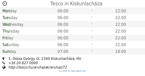
Tesco
Kiskunlacháza, Dózsa György út 1/a
Supermarket
read more
6.058 km
Tesco
Kiskunlacháza, Dózsa György út 1
Supermarket
read more
8.981 km
SPAR Partner
Ercsi, Fő utca 2
Supermarket
read more
11.02 km
National tobacco shop
Szigetcsép, Váci Mihály utca 2
Supermarket
read more
11.02 km
Nemzeti Dohánybolt
Szigetcsép, Váci Mihály utca 2
Supermarket
read more
14.579 km
SPAR Market
Pusztaszabolcs, Szabolcs liget 6
Supermarket
read more
14.602 km
HONI élelmiszer
Dunavarsány, Szabadság utca 22
Supermarket
read more
16.812 km
SPAR Szupermarket
Tököl, 88 Fő utca
Supermarket
read more
17.439 km
SPAR Szupermarket
Szigethalom, Mű út
Supermarket
read more
17.906 km
Penny Market
Szigethalom, Mű út 41
Supermarket
read more
19.799 km
Reál Élelmiszer
Taksony, Wesselényi Miklós utca 34
Supermarket
read more
21.525 km
HK Supermarket CBA Little General Store
Kápolnásnyék, Fő utca 47
Supermarket
read more
22.487 km
SPAR Szupermarket
Velence, Tópart utca 47
Supermarket
read more
22.849 km
Tesco
Érd, Budafoki út 2-4
Supermarket
read more
22.995 km
Lidl
Érd, Diósdi út 2-4
Supermarket
read more
23.363 km
SPAR Szupermarket
Gárdony, Balatoni út 70/10
Supermarket
read more
23.722 km
Lidl
Dunaújváros, Velinszky László utca 1
Supermarket
read more
23.76 km
Tesco
Dunaharaszti, Fő u 56
Supermarket
read more
23.961 km
Penny Market
Gárdony, Szabadság út 2400/2
Supermarket
read more
25.428 km
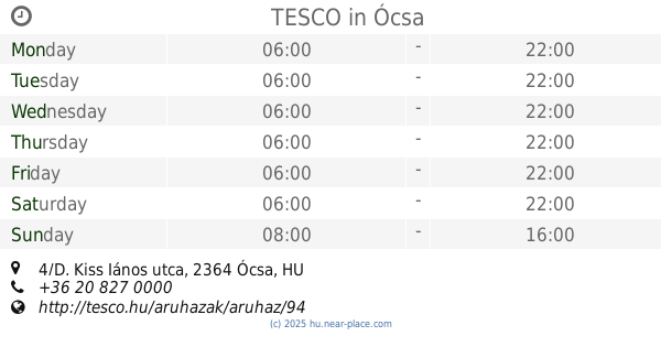
TESCO
Ócsa, Kiss János utca 4/D
Supermarket
read more
📑
all categories
Accounting
Administrative area level 1
Administrative area level 2
Airport
Amusement park
Aquarium
Art gallery
Atm
Bakery
Bank
Bar
Beauty salon
Bicycle store
Book store
Bowling alley
Bus station
Cafe
Campground
Car dealer
Car rental
Car repair
Car wash
Casino
Cemetery
Church
City hall
Clothing store
Colloquial area
Convenience store
Country
Courthouse
Dentist
Department store
Doctor
Electrician
Electronics store
Embassy
Finance
Fire station
Florist
Food
Funeral home
Furniture store
Gas station
General contractor
Grocery or supermarket
Gym
Hair care
Hardware store
Health
Hindu Temple
Home goods store
Hospital
Insurance agency
Intersection
Jewelry store
Laundry
Lawyer
Library
Light rail station
Liquor store
Local government office
Locality
Locksmith
Lodging
Meal delivery
Meal takeaway
Mosque
Movie rental
Movie theater
Moving company
Museum
Natural feature
Neighborhood
Night club
Painter
Park
Parking
Pet store
Pharmacy
Physiotherapist
Place of worship
Plumber
Point of interest
Police
Political
Post office
Premise
Real estate agency
Restaurant
Roofing contractor
Route
Rv park, camping
School
Shoe store
Shopping mall
Spa
Stadium
Storage
Store
Subpremise
Subway station
Supermarket
Synagogue
Taxi stand
Train station
Transit station
Travel agency
University
Veterinary care
Zoo
administrative area level 3
sublocality level 1
↑