Supermarket nearby Spar
Hungary
Supermarket nearby Spar
Spar
Tapolca, Juhász Gyula utca Hungary
contacts phone
:
+36
Latitude:
46.88551
, Longitude:
17.44866
read more
nearest Supermarket
667 m
Lidl
Tapolca, Veszprémi Straße 1.
Supermarket
read more
670 m
Penny Market
Tapolca, Gyulakeszi u. 120.
Supermarket
read more
682 m
Tesco
Tapolca, Veszprémi út 5
Supermarket
read more
691 m
Lidl
Tapolca
Supermarket
read more
717 m
Aldi
Tapolca, Veszprémi út 3.
Supermarket
read more
801 m
Fater Diszkont
Tapolca, Gyulakeszi út
Supermarket
read more
13.319 km
SPAR Market
Nyirád, Dózsa György utca 2
Supermarket
read more
15.24 km
Coop
Révfülöp, Balaton utca 1
Supermarket
read more
15.838 km
Tóth Lebensmittel
Révfülöp, Kacsajtosi út 12
Supermarket
read more
15.953 km
SPAR Szupermarket
Sümeg, 84-es főút
Supermarket
read more
16.658 km
Tesco
Sümeg, Baglyasszél utca 2
Supermarket
read more
17.356 km
Balaton ABC 5.sz.
Vonyarcvashegy, Kossuth Lajos utca 40
Supermarket
read more
17.367 km
Coop abc
Vonyarcvashegy, Kossuth Lajos utca 40
Supermarket
read more
17.475 km
Lidl
Fonyód, Ady Endre utca 57-59
Supermarket
read more
17.866 km
Aldi
Keszthely, Tündérlak út 2.
Supermarket
read more
17.869 km
ALDI Keszthely
Keszthely, Tündérlak út 2.
Supermarket
read more
18.292 km
Lidl
Keszthely
Supermarket
read more
18.505 km
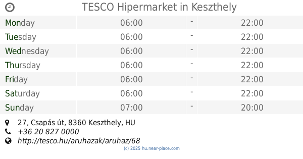
Tesco Hypermarket
Keszthely, Csapás út 27
Supermarket
read more
18.505 km
TESCO Hipermarket
Keszthely, Csapás út 27
Supermarket
read more
18.505 km
Tesco
Keszthely, Csapás út 27
Supermarket
read more
18.528 km
INTERSPAR Hipermarket
Keszthely, Tapolcai út 37
Supermarket
read more
18.528 km
Interspar
Keszthely, Tapolcai út 37
Supermarket
read more
18.679 km
Penny Market
Keszthely, Frech Miklós u. 1.
Supermarket
read more
19.442 km
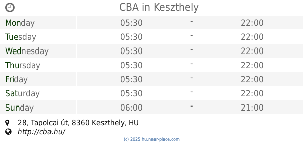
CBA
Keszthely, Tapolcai út 28
Supermarket
read more
19.896 km
Lidl
Keszthely, Sopron utca 43
Supermarket
read more
📑
all categories
Accounting
Administrative area level 1
Administrative area level 2
Airport
Amusement park
Aquarium
Art gallery
Atm
Bakery
Bank
Bar
Beauty salon
Bicycle store
Book store
Bowling alley
Bus station
Cafe
Campground
Car dealer
Car rental
Car repair
Car wash
Casino
Cemetery
Church
City hall
Clothing store
Colloquial area
Convenience store
Country
Courthouse
Dentist
Department store
Doctor
Electrician
Electronics store
Embassy
Finance
Fire station
Florist
Food
Funeral home
Furniture store
Gas station
General contractor
Grocery or supermarket
Gym
Hair care
Hardware store
Health
Hindu Temple
Home goods store
Hospital
Insurance agency
Intersection
Jewelry store
Laundry
Lawyer
Library
Light rail station
Liquor store
Local government office
Locality
Locksmith
Lodging
Meal delivery
Meal takeaway
Mosque
Movie rental
Movie theater
Moving company
Museum
Natural feature
Neighborhood
Night club
Painter
Park
Parking
Pet store
Pharmacy
Physiotherapist
Place of worship
Plumber
Point of interest
Police
Political
Post office
Premise
Real estate agency
Restaurant
Roofing contractor
Route
Rv park, camping
School
Shoe store
Shopping mall
Spa
Stadium
Storage
Store
Subpremise
Subway station
Supermarket
Synagogue
Taxi stand
Train station
Transit station
Travel agency
University
Veterinary care
Zoo
administrative area level 3
sublocality level 1
↑