Store nearby Szlovák úti papírbolt
Hungary
Store nearby Szlovák úti papírbolt
Szlovák úti papírbolt
129, Szlovák út, 1162, Budapest, HU Magyarország
contacts phone
:
+36 30 568 3468
website:
ceruzahegyek.business.site
Latitude:
47.529995
, Longitude:
19.192487
larger map & directions
read more
nearest Store
15 m
Nemzeti Dohanybolt
Budapest, Szlovák út 129
Store
read more
15 m
National tobacco shop
Budapest, Szlovák út 129
Store
read more
29 m
Biztos-Pontok Szerelvény üzlet
Budapest, Szlovák út 134
Store
read more
373 m
Jarabo-96 Kft. - Metal hardware store, hardware store Budapest
Budapest, Szlovák út 111
Store
read more
373 m
Jarabik-96 Kft. - Vasáru kereskedés, vaskereskedés Budapest
Budapest, Szlovák út 111
Store
read more
519 m
BandeR Bt.
Budapest, Béla utca 228
Store
read more
528 m
Tam-méz Kft
Budapest, Szlovák út 101
Store
read more
643 m
B-B Bt.
Budapest, 59, Vadruca utca 57
Store
read more
710 m
V-Diszkont - Vegyesbolt
Budapest, Menyhért utca 27
Store
read more
740 m
Gold-lakk kft
Budapest, Szlovák út 98b
Store
read more
752 m
Termelői Magyar Méz
Budapest, Irha utca 31
Store
read more
765 m
Botz-Takt Kft.
Budapest, Felcsúti utca 75/a
Store
read more
788 m
Pékség
Budapest, Irha utca 5
Store
read more
825 m
kilincstar.hu
Budapest, Felsőmalom utca 12
Store
read more
839 m
Fürge Füge Kft.
Budapest, Muzsika utca 36
Store
read more
850 m
ekilincs.hu
Budapest, Felsőmalom utca 12
Store
read more
907 m
Okoskajáték
Budapest, Felsőmalom utca 16
Store
read more
919 m
Marton és Marton Kft
Budapest, Szent Korona utca 229
Store
read more
958 m
D-T Közmű Kft.
Budapest, Szénás utca 90
Store
read more
1.006 km
Élelmiszerbolt
Budapest, Timur utca 96
Store
read more
1.03 km
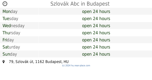
Szlovák Abc
Budapest, Szlovák út 79
Store
read more
1.062 km
KAPLANBAU KFT.
Budapest, Csömöri út 272
Store
read more
1.102 km
Nemzeti Dohánybolt
Budapest, Géza utca 84
Store
read more
1.156 km
Alita kreatív műhely
Budapest, Ferenc utca 126/a
Store
read more
1.328 km
AUTOALKATRÉSZ ÉS SZERVIZ
Budapest, Istráng utca 78
Store
read more
📑
all categories
Accounting
Administrative area level 1
Administrative area level 2
Airport
Amusement park
Aquarium
Art gallery
Atm
Bakery
Bank
Bar
Beauty salon
Bicycle store
Book store
Bowling alley
Bus station
Cafe
Campground
Car dealer
Car rental
Car repair
Car wash
Casino
Cemetery
Church
City hall
Clothing store
Colloquial area
Convenience store
Country
Courthouse
Dentist
Department store
Doctor
Electrician
Electronics store
Embassy
Finance
Fire station
Florist
Food
Funeral home
Furniture store
Gas station
General contractor
Grocery or supermarket
Gym
Hair care
Hardware store
Health
Hindu Temple
Home goods store
Hospital
Insurance agency
Intersection
Jewelry store
Laundry
Lawyer
Library
Light rail station
Liquor store
Local government office
Locality
Locksmith
Lodging
Meal delivery
Meal takeaway
Mosque
Movie rental
Movie theater
Moving company
Museum
Natural feature
Neighborhood
Night club
Painter
Park
Parking
Pet store
Pharmacy
Physiotherapist
Place of worship
Plumber
Point of interest
Police
Political
Post office
Premise
Real estate agency
Restaurant
Roofing contractor
Route
Rv park, camping
School
Shoe store
Shopping mall
Spa
Stadium
Storage
Store
Subpremise
Subway station
Supermarket
Synagogue
Taxi stand
Train station
Transit station
Travel agency
University
Veterinary care
Zoo
administrative area level 3
sublocality level 1
↑