Store nearby Nemzeti dohánybolt
Hungary
Store nearby Nemzeti dohánybolt
Nemzeti dohánybolt
Nyíregyháza, Ungvár sétány 11 Magyarország
contacts phone
:
+36
Latitude:
47.9733491
, Longitude:
21.7229044
read more
nearest Store
48 m
ANZSU OPTIKA
Nyíregyháza, Ungvár sétány 17
Store
read more
68 m
Real Pont
Nyíregyháza, Ungvár sétány 7
Store
read more
131 m
Ilecskó Húsbolt
Nyíregyháza, Ungvár sétány 21
Store
read more
279 m
Lottózó
Nyíregyháza, Ungvár sétány 35
Store
read more
354 m
Szivárvány Box Műköröm és Ajándék
Nyíregyháza, Korányi Frigyes utca 7
Store
read more
376 m
Ózon Mini ABC
Nyíregyháza, Kond utca 9
Store
read more
377 m
OptikStúdió Szemüvegszalon Optika
Nyíregyháza, Interspar, Korányi Frigyes utca 5
Store
read more
379 m
Szépségvarázs Kozmetika & Szolárium
Nyíregyháza, Ószőlő utca 117
Store
read more
427 m
Nemzeti Dohánybolt
Nyíregyháza, Garibaldi utca 57
Store
read more
447 m
National tobacco shop
Nyíregyháza, Korányi Frigyes utca 72
Store
read more
451 m
Dohánybolt
Nyíregyháza, Kodály Zoltán utca 41
Store
read more
538 m
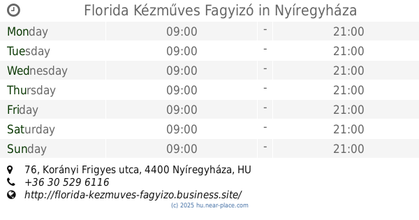
Florida Kézműves Fagyizó
Nyíregyháza, Korányi Frigyes utca 76
Store
read more
807 m
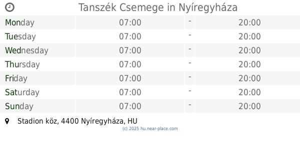
Tanszék Csemege
Nyíregyháza, Stadion köz
Store
read more
825 m
Stadion Fagylaltozó
Nyíregyháza, Sóstói út
Store
read more
916 m
Solar-Holding Kft.
Nyíregyháza, Pazonyi út 21
Store
read more
920 m
Alfi
Nyíregyháza, Pazonyi tér 9
Store
read more
936 m
Nyír-Salix Kft. Kertészeti Áruda
Nyíregyháza, Pazonyi út 20
Store
read more
950 m
Friss Gyümölcs- és Zöldségüzlet
Nyíregyháza, Sóstói út
Store
read more
976 m
Másolda
Nyíregyháza, Sóstói út 1
Store
read more
977 m
Pony Játékkereskedés
Nyíregyháza, Pazonyi út 15
Store
read more
989 m
dm-drogerie markt
Nyíregyháza, Pazonyi út 39/a STOP SHOP
Store
read more
1.017 km
Mada Húsboltok
Nyíregyháza, Ferenc körút 1
Store
read more
1.168 km
Dohánybolt
Nyíregyháza, Szent Flórián tér 1
Store
read more
1.2 km
Gyöngyössy Cukrászda
Nyíregyháza, Család utca 152/B
Store
read more
1.203 km
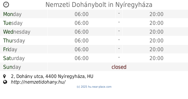
Nemzeti Dohánybolt
Nyíregyháza, Dohány utca 2
Store
read more
📑
all categories
Accounting
Administrative area level 1
Administrative area level 2
Airport
Amusement park
Aquarium
Art gallery
Atm
Bakery
Bank
Bar
Beauty salon
Bicycle store
Book store
Bowling alley
Bus station
Cafe
Campground
Car dealer
Car rental
Car repair
Car wash
Casino
Cemetery
Church
City hall
Clothing store
Colloquial area
Convenience store
Country
Courthouse
Dentist
Department store
Doctor
Electrician
Electronics store
Embassy
Finance
Fire station
Florist
Food
Funeral home
Furniture store
Gas station
General contractor
Grocery or supermarket
Gym
Hair care
Hardware store
Health
Hindu Temple
Home goods store
Hospital
Insurance agency
Intersection
Jewelry store
Laundry
Lawyer
Library
Light rail station
Liquor store
Local government office
Locality
Locksmith
Lodging
Meal delivery
Meal takeaway
Mosque
Movie rental
Movie theater
Moving company
Museum
Natural feature
Neighborhood
Night club
Painter
Park
Parking
Pet store
Pharmacy
Physiotherapist
Place of worship
Plumber
Point of interest
Police
Political
Post office
Premise
Real estate agency
Restaurant
Roofing contractor
Route
Rv park, camping
School
Shoe store
Shopping mall
Spa
Stadium
Storage
Store
Subpremise
Subway station
Supermarket
Synagogue
Taxi stand
Train station
Transit station
Travel agency
University
Veterinary care
Zoo
administrative area level 3
sublocality level 1
↑