Store nearby Élelmiszer Csemege
Hungary
Store nearby Élelmiszer Csemege
Élelmiszer Csemege
150, Németvölgyi út, 1112, Budapest, HU Magyarország
contacts phone
:
+36
Latitude:
47.4813639
, Longitude:
19.005189
larger map & directions
read more
nearest Store
20 m
Hentes
Budapest, Németvölgyi út 150
Store
read more
379 m
azenpiacom.hu
Budapest, Érdi út 16
Store
read more
449 m
Faház Közért
Budapest, Sasadi út 148
Store
read more
449 m
Faház Csemege
Budapest, Sasadi út 148
Store
read more
522 m
ALAKart Ipar- és Képzőművészeti Korlátolt Felelősségű Társaság
Budapest, Tagló utca 11
Store
read more
532 m
Kft.
Budapest, Törökbálinti út 2
Store
read more
663 m
Rusznák Kerámia Stúdió Bt.
Budapest, Cseresznye utca 49
Store
read more
772 m
AndTECH MIGS Kft.
Budapest, Zsigmondy Vilmos utca 2
Store
read more
827 m
TOPCORN Kft.
Budapest, Katafa utca 8
Store
read more
880 m
Vágókorongposta
Budapest, Szent Adalbert tér
Store
read more
914 m
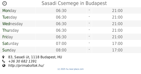
Sasadi Csemege
Budapest, Sasadi út 83
Store
read more
914 m
Príma - Sasadi Csemege
Budapest, Sasadi út 83
Store
read more
950 m
Kvalifik Méréstechnikai Minősítő és Szolgáltató Kft.
Budapest, Sasadi út 78
Store
read more
956 m
Sashegy Csemege ABC
Budapest, Hegyalja út 95
Store
read more
958 m
Kristály Klíma Plusz Kft.
Budapest, Brassó út 169
Store
read more
976 m
Felicité Kft.
Budapest, Lanka utca 22
Store
read more
990 m
Formatex Kereskedelmi Kft.
Budapest, Rétkerülő út 41
Store
read more
1.082 km
Anzsu Optika
Budapest, Rétköz utca 49b
Store
read more
1.089 km
Diamante Fagyizó
Budapest, Rétköz utca 47b
Store
read more
1.111 km
Elysium Buda
Budapest, Brassó út 169-179
Store
read more
1.146 km
Biogyógynövénybolt
Budapest, Csíkihegyek utca 26
Store
read more
1.174 km
Kintzly és Fia Kft.
1124 Budapest, Lejtő út 6.
Store
read more
1.186 km
Számir Kft.
Budapest, Tűzkő utca 10
Store
read more
1.23 km
Vadászkürt
Budapest, Gazdagréti tér 7
Store
read more
1.317 km
Optimal Optik Kft.
Budapest, Dayka Gábor utca 6b
Store
read more
📑
all categories
Accounting
Administrative area level 1
Administrative area level 2
Airport
Amusement park
Aquarium
Art gallery
Atm
Bakery
Bank
Bar
Beauty salon
Bicycle store
Book store
Bowling alley
Bus station
Cafe
Campground
Car dealer
Car rental
Car repair
Car wash
Casino
Cemetery
Church
City hall
Clothing store
Colloquial area
Convenience store
Country
Courthouse
Dentist
Department store
Doctor
Electrician
Electronics store
Embassy
Finance
Fire station
Florist
Food
Funeral home
Furniture store
Gas station
General contractor
Grocery or supermarket
Gym
Hair care
Hardware store
Health
Hindu Temple
Home goods store
Hospital
Insurance agency
Intersection
Jewelry store
Laundry
Lawyer
Library
Light rail station
Liquor store
Local government office
Locality
Locksmith
Lodging
Meal delivery
Meal takeaway
Mosque
Movie rental
Movie theater
Moving company
Museum
Natural feature
Neighborhood
Night club
Painter
Park
Parking
Pet store
Pharmacy
Physiotherapist
Place of worship
Plumber
Point of interest
Police
Political
Post office
Premise
Real estate agency
Restaurant
Roofing contractor
Route
Rv park, camping
School
Shoe store
Shopping mall
Spa
Stadium
Storage
Store
Subpremise
Subway station
Supermarket
Synagogue
Taxi stand
Train station
Transit station
Travel agency
University
Veterinary care
Zoo
administrative area level 3
sublocality level 1
↑