Restaurant nearby Tüzestál Étterem
Hungary
Restaurant nearby Tüzestál Étterem
Tüzestál Étterem
65, Váci út, 1047, Budapest, HU Magyarország
contacts phone
:
+36 1 369 4453
website:
tuzestal.hu
Latitude:
47.5721088
, Longitude:
19.0811085
larger map & directions
read more
nearest Restaurant
184 m
Lángos-Palacsinta (Kaldi Bt)
Budapest
Restaurant
read more
395 m
McDonald's
Budapest, Váci út 94-96.
Restaurant
read more
395 m
McDonald's
Budapest, Váci út 94
Restaurant
read more
661 m
Retro pecsenyesütő
Budapest, Megyeri út
Restaurant
read more
750 m
Eurest Knorr
Budapest, Helsinki út 105
Restaurant
read more
776 m
Márió Kifőzde
Budapest, Megyeri út 12
Restaurant
read more
828 m
Cső
Budapest, Deák Ferenc utca 8a
Restaurant
read more
832 m
Duna Büfé
Budapest, Károlyi István utca 10
Restaurant
read more
841 m
Kínai Gyorsbüfé
Budapest, Vasvári Pál utca 1
Restaurant
read more
841 m
Kínai Gyosfüfé
Budapest, Vasvári Pál utca 1
Restaurant
read more
858 m
Kőleves úszóház
duna
Restaurant
read more
902 m
Palinka Bistrot
Budapest, Nádor utca 5
Restaurant
read more
907 m
Kakukk Kisvendéglő
Budapest, 31, Nádor utca
Restaurant
read more
919 m
Kakukk Vendéglő
Budapest, 31, Nádor utca
Restaurant
read more
922 m
Dodo Büfé
Budapest, Megyeri út 35
Restaurant
read more
940 m
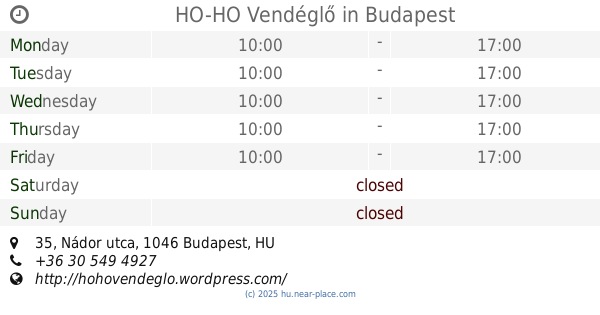
HO-HO Vendéglő
Budapest, Nádor utca 35
Restaurant
read more
1.044 km
Katica konyhája
Budapest, Fóti út 71
Restaurant
read more
1.053 km
Gyorsétterem
Budapest, Fóti út 71
Restaurant
read more
1.161 km
Kínai Étterem
Budapest, Lőrinc utca 47
Restaurant
read more
1.183 km
Hörpintő söröző
Budapest, Lőrinc utca 50
Restaurant
read more
1.187 km
Blénessy Kft. F.A.
Budapest, Reviczky utca
Restaurant
read more
1.203 km
Golyós Bár és Étterem
Budapest, Római part 45
Restaurant
read more
1.265 km
Római Platán Étterem
Budapest, Római part 18
Restaurant
read more
1.692 km
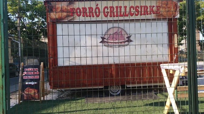
Forró Grillcsirke
Budapest, Árpád út 100a
Restaurant
read more
1.802 km
Partizán Hajó
Budapest, Népsziget út
Restaurant
read more
📑
all categories
Accounting
Administrative area level 1
Administrative area level 2
Airport
Amusement park
Aquarium
Art gallery
Atm
Bakery
Bank
Bar
Beauty salon
Bicycle store
Book store
Bowling alley
Bus station
Cafe
Campground
Car dealer
Car rental
Car repair
Car wash
Casino
Cemetery
Church
City hall
Clothing store
Colloquial area
Convenience store
Country
Courthouse
Dentist
Department store
Doctor
Electrician
Electronics store
Embassy
Finance
Fire station
Florist
Food
Funeral home
Furniture store
Gas station
General contractor
Grocery or supermarket
Gym
Hair care
Hardware store
Health
Hindu Temple
Home goods store
Hospital
Insurance agency
Intersection
Jewelry store
Laundry
Lawyer
Library
Light rail station
Liquor store
Local government office
Locality
Locksmith
Lodging
Meal delivery
Meal takeaway
Mosque
Movie rental
Movie theater
Moving company
Museum
Natural feature
Neighborhood
Night club
Painter
Park
Parking
Pet store
Pharmacy
Physiotherapist
Place of worship
Plumber
Point of interest
Police
Political
Post office
Premise
Real estate agency
Restaurant
Roofing contractor
Route
Rv park, camping
School
Shoe store
Shopping mall
Spa
Stadium
Storage
Store
Subpremise
Subway station
Supermarket
Synagogue
Taxi stand
Train station
Transit station
Travel agency
University
Veterinary care
Zoo
administrative area level 3
sublocality level 1
↑