Restaurant nearby Halásztanya
Hungary
Restaurant nearby Halásztanya
Halásztanya
6, Városház tér, 1195, Budapest, HU Magyarország
contacts phone
:
+36
website:
halasztanyaetterem.com
Latitude:
47.4528562
, Longitude:
19.1508313
larger map & directions
read more
nearest Restaurant
100 m
Konyhakert Étterem
Budapest, Árpád utca 8a
Restaurant
read more
145 m
Budafok Fékező U 1 Vasmacska Terasz
Budapest, Zrínyi utca 2
Restaurant
read more
188 m
Pizza Hut Üllő út
Budapest, Üllői út 283
Restaurant
read more
188 m
Pizza Hut
Budapest, Üllői út 283
Restaurant
read more
213 m
Söröző, Étkezde
Budapest, Üllői út 285
Restaurant
read more
233 m
Logthina kft
Budapest
Restaurant
read more
234 m
Kínai Gyros Büfé
Budapest
Restaurant
read more
239 m
Bambusz Büfé
Budapest, Üllői út 248
Restaurant
read more
325 m
Empire Gyros, Burger
Budapest, Üllői út 277/9
Restaurant
read more
329 m
Piccolo Sörbár
Budapest, Üllői út 275
Restaurant
read more
374 m
E.SSo Büfé
Budapest, Vas Gereben utca 2-4
Restaurant
read more
397 m
Kínai gyorsbüfé
Budapest, Üllői út 299
Restaurant
read more
485 m
La Guna Étterem és Pizzéria
Budapest, 1191, Fő utca 1
Restaurant
read more
493 m
Pasa Kebab
Budapest, Üllői út 269
Restaurant
read more
510 m
Rétesbolt
Budapest, Üllői út 267
Restaurant
read more
541 m
No megállj csak
Budapest, 275, Üllői út
Restaurant
read more
710 m
Döner Kebab
Budapest, Kossuth tér 1-6
Restaurant
read more
785 m
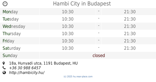
Hambi City
Budapest, Hunyadi utca 18a
Restaurant
read more
789 m
Döner Kebab Express
Budapest, kispest 1191, Kossuth tér, 1191
Restaurant
read more
869 m
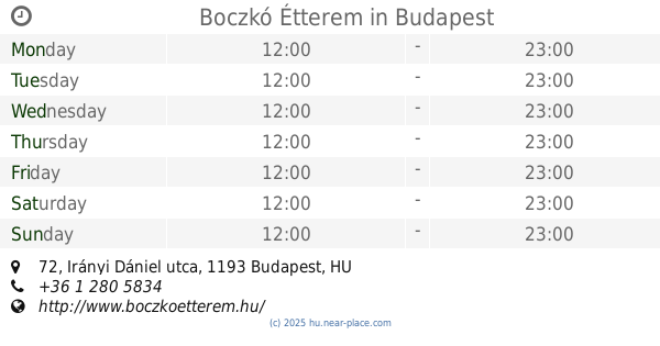
Boczkó Étterem
Budapest, Irányi Dániel utca 72
Restaurant
read more
968 m
Laguna shusi
Budapest, Üllői út 214
Restaurant
read more
983 m
Kispesti Aranyház
Budapest, Eötvös utca 3-7
Restaurant
read more
985 m
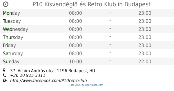
P10 Kisvendéglő és Retro Klub
Budapest, Áchim András utca 37
Restaurant
read more
1.026 km
Leonidas Gyros
Budapest, Üllői út 216
Restaurant
read more
1.192 km
Marovisz
Budapest, Üllői út 206
Restaurant
read more
📑
all categories
Accounting
Administrative area level 1
Administrative area level 2
Airport
Amusement park
Aquarium
Art gallery
Atm
Bakery
Bank
Bar
Beauty salon
Bicycle store
Book store
Bowling alley
Bus station
Cafe
Campground
Car dealer
Car rental
Car repair
Car wash
Casino
Cemetery
Church
City hall
Clothing store
Colloquial area
Convenience store
Country
Courthouse
Dentist
Department store
Doctor
Electrician
Electronics store
Embassy
Finance
Fire station
Florist
Food
Funeral home
Furniture store
Gas station
General contractor
Grocery or supermarket
Gym
Hair care
Hardware store
Health
Hindu Temple
Home goods store
Hospital
Insurance agency
Intersection
Jewelry store
Laundry
Lawyer
Library
Light rail station
Liquor store
Local government office
Locality
Locksmith
Lodging
Meal delivery
Meal takeaway
Mosque
Movie rental
Movie theater
Moving company
Museum
Natural feature
Neighborhood
Night club
Painter
Park
Parking
Pet store
Pharmacy
Physiotherapist
Place of worship
Plumber
Point of interest
Police
Political
Post office
Premise
Real estate agency
Restaurant
Roofing contractor
Route
Rv park, camping
School
Shoe store
Shopping mall
Spa
Stadium
Storage
Store
Subpremise
Subway station
Supermarket
Synagogue
Taxi stand
Train station
Transit station
Travel agency
University
Veterinary care
Zoo
administrative area level 3
sublocality level 1
↑