Restaurant nearby Fornetti
Hungary
Restaurant nearby Fornetti
Fornetti
Kecskemét, Festő utca 2 Magyarország
contacts phone
:
+36
Latitude:
46.9063502
, Longitude:
19.689703
read more
nearest Restaurant
79 m
FőzelékHáz Étterem
Kecskemét, Deák Ferenc tér 6
Restaurant
read more
151 m
Pasta Mia
Kecskemét, Csányi utca 3
Restaurant
read more
155 m
KFC
Kecskemét, Korona utca 2
Restaurant
read more
167 m
Duna Döner
Kecskemét, Dobó István körút 3
Restaurant
read more
169 m
Duna Döner Kecskemét
Kecskemét, Petőfi Sándor utca
Restaurant
read more
188 m
Dixie Gyorsétterem
Kecskemét, Petőfi Sándor utca 1
Restaurant
read more
212 m
Kecskeméti Csárda Kft.
Kecskemét, Kölcsey utca 7
Restaurant
read more
212 m
Kecskeméti Csárda és Borház
Kecskemét, Kölcsey utca 7
Restaurant
read more
227 m
Vágódeszka
Kecskemét, Széchenyi tér 12
Restaurant
read more
230 m
Nagymama konyhálya
Kecskemét, Szabadság tér
Restaurant
read more
248 m
Rozmaring Étterem
Kecskemét, Mária utca 1
Restaurant
read more
257 m
Jalta Kft.
Kecskemét, Batthyány utca 2
Restaurant
read more
260 m
Bors Étterem
Kecskemét, Széchenyiváros
Restaurant
read more
300 m
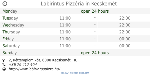
Labirintus Pizzéria
Kecskemét, Kéttemplom köz 2
Restaurant
read more
344 m
Mathias Pizzéria Söröző Pub
Kecskemét, Batthyány utca 10-12
Restaurant
read more
381 m
Italia Pizzeria
Kecskemét, Hornyik János körút 4
Restaurant
read more
392 m
Chicken-Food Kft.
Kecskemét, Szabadság tér 3
Restaurant
read more
451 m
Veyron Ebédlő és Rendezvényház
Kecskemét, u 6000, Horog utca 9
Restaurant
read more
556 m
Milandi
Kecskemét, Horváth Cirill tér 2/b
Restaurant
read more
596 m
48 Étterem és Bár
Kecskemét, Bánk bán utca 9
Restaurant
read more
743 m
Cézár Étterem
Kecskemét, Kaszap utca 4
Restaurant
read more
857 m
Jófalat Vendéglő
6000 Kecskemét, Dózsa Gy. út 13
Restaurant
read more
857 m
Sutus Vendéglő
Kecskemét, Dózsa György út 13
Restaurant
read more
861 m
Olivolà - Locale Italiano
Kecskemét, Rákóczi út 28
Restaurant
read more
1.184 km
Resti Söröző
Kecskemét, Kodály Zoltán I. tér 5
Restaurant
read more
📑
all categories
Accounting
Administrative area level 1
Administrative area level 2
Airport
Amusement park
Aquarium
Art gallery
Atm
Bakery
Bank
Bar
Beauty salon
Bicycle store
Book store
Bowling alley
Bus station
Cafe
Campground
Car dealer
Car rental
Car repair
Car wash
Casino
Cemetery
Church
City hall
Clothing store
Colloquial area
Convenience store
Country
Courthouse
Dentist
Department store
Doctor
Electrician
Electronics store
Embassy
Finance
Fire station
Florist
Food
Funeral home
Furniture store
Gas station
General contractor
Grocery or supermarket
Gym
Hair care
Hardware store
Health
Hindu Temple
Home goods store
Hospital
Insurance agency
Intersection
Jewelry store
Laundry
Lawyer
Library
Light rail station
Liquor store
Local government office
Locality
Locksmith
Lodging
Meal delivery
Meal takeaway
Mosque
Movie rental
Movie theater
Moving company
Museum
Natural feature
Neighborhood
Night club
Painter
Park
Parking
Pet store
Pharmacy
Physiotherapist
Place of worship
Plumber
Point of interest
Police
Political
Post office
Premise
Real estate agency
Restaurant
Roofing contractor
Route
Rv park, camping
School
Shoe store
Shopping mall
Spa
Stadium
Storage
Store
Subpremise
Subway station
Supermarket
Synagogue
Taxi stand
Train station
Transit station
Travel agency
University
Veterinary care
Zoo
administrative area level 3
sublocality level 1
↑