Restaurant nearby Arcus Étterem
Hungary
Restaurant nearby Arcus Étterem
Arcus Étterem
Sopron, Bécsi út Magyarország
contacts phone
:
+36
Latitude:
47.7158916
, Longitude:
16.5709389
read more
nearest Restaurant
Arcus Restaurant
Sopron, Bécsi út
Restaurant
read more
2.144 km
Kamibi Kürtőskalács
Sopron
Restaurant
read more
2.218 km
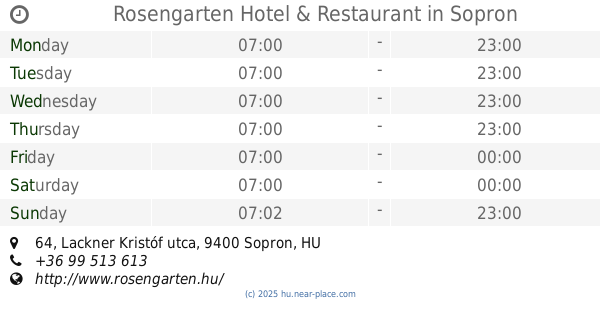
Rosengarten Hotel & Restaurant
Sopron, Lackner Kristóf utca 64
Restaurant
read more
2.458 km
Solo restaurant
Sopron, Lackner Kristóf utca 33
Restaurant
read more
2.458 km
Solo étterem
Sopron, Lackner Kristóf utca 33
Restaurant
read more
2.623 km
McDonald's
Sopron, Lackner Kristóf utca 60
Restaurant
read more
2.691 km
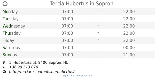
Tercia Hubertus
Sopron, Hubertusz út 1
Restaurant
read more
2.824 km
Schnitzel-Ház
Sopron, Teleki Pál út 24
Restaurant
read more
2.831 km
Jimy's Kebab Bisztro
Sopron, Teleki Pál út 22
Restaurant
read more
2.853 km
Aramis Söröző és Kávézó
Sopron, Erdély utca 1
Restaurant
read more
2.855 km
Pizzeria Il Basilico
Sopron
Restaurant
read more
2.859 km
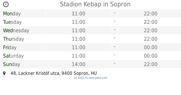
Stadion Kebap
Sopron, Lackner Kristóf utca 48
Restaurant
read more
2.881 km
Nina Gluténmentes Falatozója
Sopron, IV. László király utca 5
Restaurant
read more
2.91 km
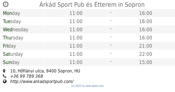
Árkád Sport Pub és Étterem
Sopron, Hőflányi utca 10
Restaurant
read more
2.914 km
Árvay Csárda
Sopron, Hőflányi utca 10
Restaurant
read more
2.942 km
Pizza Di Casa Sopron
Sopron, Baross út 24/a
Restaurant
read more
2.975 km
Zanza Bisztro
Sopron, Gyár utca 1
Restaurant
read more
3.01 km
Hopsz Café & Grill
Sopron, Gyár utca 1-3
Restaurant
read more
3.011 km
Old Boys
Sopron, 1, Gyár utca
Restaurant
read more
3.027 km
Kínai Gyorsbüfé Kkt.
Sopron, Lackner Kristóf utca 35
Restaurant
read more
3.055 km
Zanza Bistro
Sopron
Restaurant
read more
3.169 km
Duna Döner Sopron - Kebab, dürüm, pizza
Sopron, Ferenczy János utca 58
Restaurant
read more
3.525 km
Schmauser Söröző
Sopron, Kossuth Lajos utca 49
Restaurant
read more
3.73 km
Harap6 falatozó
Sopron, Tómalom utca 34
Restaurant
read more
3.993 km
Juventus Tanétterem
Sopron, Füredi sétány 8.
Restaurant
read more
📑
all categories
Accounting
Administrative area level 1
Administrative area level 2
Airport
Amusement park
Aquarium
Art gallery
Atm
Bakery
Bank
Bar
Beauty salon
Bicycle store
Book store
Bowling alley
Bus station
Cafe
Campground
Car dealer
Car rental
Car repair
Car wash
Casino
Cemetery
Church
City hall
Clothing store
Colloquial area
Convenience store
Country
Courthouse
Dentist
Department store
Doctor
Electrician
Electronics store
Embassy
Finance
Fire station
Florist
Food
Funeral home
Furniture store
Gas station
General contractor
Grocery or supermarket
Gym
Hair care
Hardware store
Health
Hindu Temple
Home goods store
Hospital
Insurance agency
Intersection
Jewelry store
Laundry
Lawyer
Library
Light rail station
Liquor store
Local government office
Locality
Locksmith
Lodging
Meal delivery
Meal takeaway
Mosque
Movie rental
Movie theater
Moving company
Museum
Natural feature
Neighborhood
Night club
Painter
Park
Parking
Pet store
Pharmacy
Physiotherapist
Place of worship
Plumber
Point of interest
Police
Political
Post office
Premise
Real estate agency
Restaurant
Roofing contractor
Route
Rv park, camping
School
Shoe store
Shopping mall
Spa
Stadium
Storage
Store
Subpremise
Subway station
Supermarket
Synagogue
Taxi stand
Train station
Transit station
Travel agency
University
Veterinary care
Zoo
administrative area level 3
sublocality level 1
↑