Premise nearby Városi Sporttelep
Coronavirus disease (COVID-19) Situation
confirmed cases
2230232
deaths
49048
Hungary
Premise nearby Városi Sporttelep
Városi Sporttelep
Szentgotthárd Hungary
contacts phone
:
+36
Latitude:
46.9535341
, Longitude:
16.2827663
read more
nearest Premise
5.693 km
Geodéziai torony
Szentgotthárd
Premise
read more
6.581 km
Gokart Rad Ring
Rönök
Premise
read more
9.999 km
Rábagyarmati Focipálya
Rábagyarmat
Premise
read more
10.475 km
Nemesmedves Történelmi Emlékhely Természetvédelmi terület
Nemesmedves
Premise
read more
19.497 km
Vasaljai Focipálya
Vasalja
Premise
read more
23.627 km
Alsóberkifalu
Körmend
Premise
read more
24.221 km
Nádasd Focipálya
Nádasd
Premise
read more
25.909 km
Körmendi Kastélypark Természetvédelmi terület
Körmend
Premise
read more
26.066 km
Körmend FC Focipálya
Körmend
Premise
read more
26.223 km
Katafai Focipálya
Nádasd
Premise
read more
30.693 km
Roman Catholic Church of St George the Martyr
Ják
Premise
read more
39.542 km
Berzsenyi Dániel Főiskola Szombathely
Szombathely
Premise
read more
39.645 km
Reiner és Kanti Kkt.
Szombathely, Komlósi Ferenc utca 51
Premise
read more
41.202 km
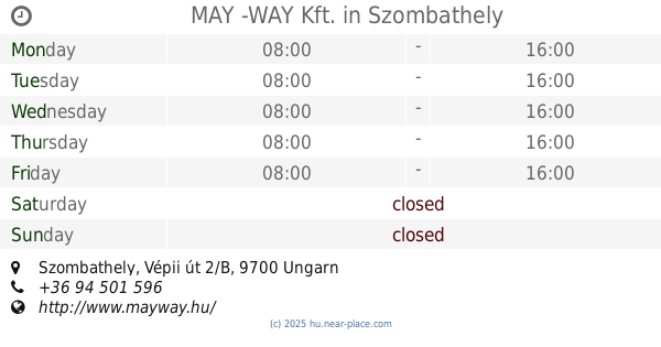
MAY -WAY Kft.
Szombathely, Vépii út 2/B
Premise
read more
42.32 km
Suller László
Püspökmolnári, Kossuth Lajos utca 138
Premise
read more
42.646 km
Szovjet katonai temető
Zalaegerszeg
Premise
read more
43.99 km
Várkastély
Egervár
Premise
read more
44.088 km
Dózsa Pálya
Zalaegerszeg
Premise
read more
44.218 km
Táncoló lány 1980
Zalaegerszeg
Premise
read more
44.525 km
Keresztury Dezső Szobra
Zalaegerszeg
Premise
read more
44.558 km
Zalai nemes szobra
Zalaegerszeg
Premise
read more
44.707 km
Medgyessy Ferenc
Zalaegerszeg
Premise
read more
44.751 km
Szent Imre utcai sporttelep
Vép
Premise
read more
54.616 km
II.Stáció
Csénye
Premise
read more
62.308 km
Rábapaty KSK
Rábapaty
Premise
read more
📑
all categories
Accounting
Administrative area level 1
Administrative area level 2
Airport
Amusement park
Aquarium
Art gallery
Atm
Bakery
Bank
Bar
Beauty salon
Bicycle store
Book store
Bowling alley
Bus station
Cafe
Campground
Car dealer
Car rental
Car repair
Car wash
Casino
Cemetery
Church
City hall
Clothing store
Colloquial area
Convenience store
Country
Courthouse
Dentist
Department store
Doctor
Electrician
Electronics store
Embassy
Finance
Fire station
Florist
Food
Funeral home
Furniture store
Gas station
General contractor
Grocery or supermarket
Gym
Hair care
Hardware store
Health
Hindu Temple
Home goods store
Hospital
Insurance agency
Intersection
Jewelry store
Laundry
Lawyer
Library
Light rail station
Liquor store
Local government office
Locality
Locksmith
Lodging
Meal delivery
Meal takeaway
Mosque
Movie rental
Movie theater
Moving company
Museum
Natural feature
Neighborhood
Night club
Painter
Park
Parking
Pet store
Pharmacy
Physiotherapist
Place of worship
Plumber
Point of interest
Police
Political
Post office
Premise
Real estate agency
Restaurant
Roofing contractor
Route
Rv park, camping
School
Shoe store
Shopping mall
Spa
Stadium
Storage
Store
Subpremise
Subway station
Supermarket
Synagogue
Taxi stand
Train station
Transit station
Travel agency
University
Veterinary care
Zoo
administrative area level 3
sublocality level 1
↑