Premise nearby UTE atlétikai stadion
Coronavirus disease (COVID-19) Situation
confirmed cases
2230232
deaths
49048
Hungary
Premise nearby UTE atlétikai stadion
UTE atlétikai stadion
IV. kerület Węgry
contacts phone
:
+36
Latitude:
47.5740117
, Longitude:
19.1131888
read more
nearest Premise
265 m
Tungsram sporttelep
IV. kerület
Premise
read more
450 m
Chinoin sporttelep
IV. kerület
Premise
read more
693 m
Szilas park játszótér
Újpest
Premise
read more
693 m
Szilas park játszótér
IV. Budapester Bezirk
Premise
read more
693 m
Szilas park játszótér
IV. kerület
Premise
read more
693 m
Szilas park játszótér
District IV.
Premise
read more
710 m
Capri
IV. kerület
Premise
read more
758 m
Blaha Lujza utcai focipálya
IV. kerület
Premise
read more
948 m
Szentháromság Plébánia
IV. kerület
Premise
read more
1.232 km
Park Óvoda
IV. kerület
Premise
read more
1.25 km
Spar
IV. kerület
Premise
read more
1.352 km
PX-2 társasház
IV. kerület
Premise
read more
1.388 km
Újpesti Víztorony
IV. kerület
Premise
read more
1.755 km
REX Kutyaotthon Alapítvány
IV. kerület
Premise
read more
1.789 km
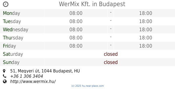
WerMix Kft.
Budapest, Megyeri út 51
Premise
read more
1.838 km
Lidl
IV. kerület
Premise
read more
1.886 km
Árpád Üzletház
IV. kerület
Premise
read more
1.986 km
Kisjátszótér
IV. Budapester Bezirk
Premise
read more
1.986 km
Kisjátszótér
IV. kerület
Premise
read more
1.986 km
Kisjátszótér
District IV.
Premise
read more
1.986 km
Kisjátszótér
Újpest
Premise
read more
2.065 km
Posta
IV. kerület
Premise
read more
2.104 km
ELMŰ
IV. kerület
Premise
read more
2.186 km
IV. kerület Újpest Polgármesteri Hivatal
IV. kerület
Premise
read more
2.32 km
Állami Áruház
IV. kerület
Premise
read more
📑
all categories
Accounting
Administrative area level 1
Administrative area level 2
Airport
Amusement park
Aquarium
Art gallery
Atm
Bakery
Bank
Bar
Beauty salon
Bicycle store
Book store
Bowling alley
Bus station
Cafe
Campground
Car dealer
Car rental
Car repair
Car wash
Casino
Cemetery
Church
City hall
Clothing store
Colloquial area
Convenience store
Country
Courthouse
Dentist
Department store
Doctor
Electrician
Electronics store
Embassy
Finance
Fire station
Florist
Food
Funeral home
Furniture store
Gas station
General contractor
Grocery or supermarket
Gym
Hair care
Hardware store
Health
Hindu Temple
Home goods store
Hospital
Insurance agency
Intersection
Jewelry store
Laundry
Lawyer
Library
Light rail station
Liquor store
Local government office
Locality
Locksmith
Lodging
Meal delivery
Meal takeaway
Mosque
Movie rental
Movie theater
Moving company
Museum
Natural feature
Neighborhood
Night club
Painter
Park
Parking
Pet store
Pharmacy
Physiotherapist
Place of worship
Plumber
Point of interest
Police
Political
Post office
Premise
Real estate agency
Restaurant
Roofing contractor
Route
Rv park, camping
School
Shoe store
Shopping mall
Spa
Stadium
Storage
Store
Subpremise
Subway station
Supermarket
Synagogue
Taxi stand
Train station
Transit station
Travel agency
University
Veterinary care
Zoo
administrative area level 3
sublocality level 1
↑