Park nearby Magyar Élelmiszerbank Egyesület
Hungary
Park nearby Magyar Élelmiszerbank Egyesület
Magyar Élelmiszerbank Egyesület
Budapest, Lokátor utca 3 Ungarn
contacts phone
:
+36
Latitude:
47.495346
, Longitude:
19.2318922
read more
nearest Park
1.408 km
Heltai tér
Budapest, Heltai tér 1
Park
read more
1.497 km
Offset Park
Budapest, Zsemlékes út 25
Park
read more
1.733 km
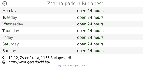
Zsarnó park
Budapest, Zsarnó utca 10-12
Park
read more
1.787 km
Park
Budapest
Park
read more
1.787 km
Népkert park
Budapest
Park
read more
1.883 km
Pesti úti sportpálya
Budapest
Park
read more
1.942 km
Petőfi tér
Budapest, Lepkevirág utca 9
Park
read more
1.942 km
Petofi Square
Budapest, Lepkevirág utca 9
Park
read more
2.181 km
Hősök tere
Budapest
Park
read more
2.181 km
Hősök tere
Budapeszt
Park
read more
2.206 km
Calvary of Rákosliget
Budapest, Fackh Károly tér
Park
read more
2.239 km
Gyökér utcai kutyafuttató
Budapest, Gyökér utca 83
Park
read more
2.42 km
Kertépítés - KertKozmetika.hu
Budapest, Szikra utca 1
Park
read more
2.456 km
Cinkotai Royal Ground
Budapest, Somkút utca 10.
Park
read more
2.736 km
Aviation Memorial
Budapest, Újszász utca 45c
Park
read more
2.736 km
Repülős emlékmű
Budapest, Újszász utca 45c
Park
read more
2.801 km
Erzsébet liget
Budapest, Hunyadvár utca 43a
Park
read more
2.901 km
Mátyás király tér
Budapeszt
Park
read more
2.901 km
Mátyás király tér
Budapest
Park
read more
2.976 km
Cinkota Beach Gardens
Budapest
Park
read more
2.976 km
Cinkota Strand Kert
Budapest
Park
read more
3.316 km
SRMaster - "Kulcsrakész" kert
Budapest, Bélavár utca 77
Park
read more
3.535 km
Gramen Kft.
Nagytarcsa, Szilas utca 4
Park
read more
3.573 km
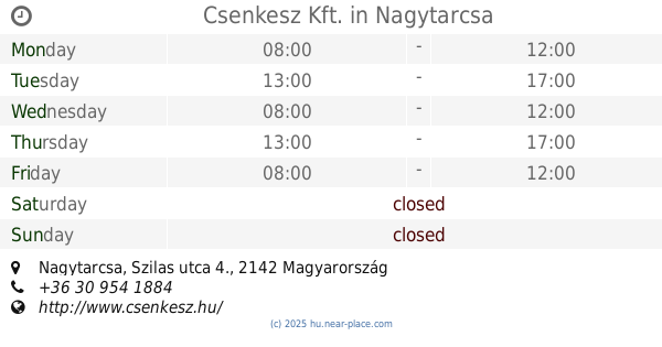
Csenkesz Kft.
Nagytarcsa, Szilas utca 4.
Park
read more
3.774 km
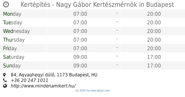
Kertépítés - Nagy Gábor Kertészmérnök
Budapest, Agyaghegyi dűlő 84
Park
read more
📑
all categories
Accounting
Administrative area level 1
Administrative area level 2
Airport
Amusement park
Aquarium
Art gallery
Atm
Bakery
Bank
Bar
Beauty salon
Bicycle store
Book store
Bowling alley
Bus station
Cafe
Campground
Car dealer
Car rental
Car repair
Car wash
Casino
Cemetery
Church
City hall
Clothing store
Colloquial area
Convenience store
Country
Courthouse
Dentist
Department store
Doctor
Electrician
Electronics store
Embassy
Finance
Fire station
Florist
Food
Funeral home
Furniture store
Gas station
General contractor
Grocery or supermarket
Gym
Hair care
Hardware store
Health
Hindu Temple
Home goods store
Hospital
Insurance agency
Intersection
Jewelry store
Laundry
Lawyer
Library
Light rail station
Liquor store
Local government office
Locality
Locksmith
Lodging
Meal delivery
Meal takeaway
Mosque
Movie rental
Movie theater
Moving company
Museum
Natural feature
Neighborhood
Night club
Painter
Park
Parking
Pet store
Pharmacy
Physiotherapist
Place of worship
Plumber
Point of interest
Police
Political
Post office
Premise
Real estate agency
Restaurant
Roofing contractor
Route
Rv park, camping
School
Shoe store
Shopping mall
Spa
Stadium
Storage
Store
Subpremise
Subway station
Supermarket
Synagogue
Taxi stand
Train station
Transit station
Travel agency
University
Veterinary care
Zoo
administrative area level 3
sublocality level 1
↑