Park nearby Lehel utcai kutyafuttató
Hungary
Park nearby Lehel utcai kutyafuttató
Lehel utcai kutyafuttató
Budapest, 1135 Magyarország
contacts phone
:
+36
Latitude:
47.523285
, Longitude:
19.0730693
larger map & directions
read more
nearest Park
149 m
Tüzér park
Budapest, Csángó utca 28
Park
read more
327 m
Tüzér utcai kutyafuttató
Budapest, Tüzér utca 37
Park
read more
618 m
Kassák park
Budapest, Tüzér utca 20
Park
read more
678 m
Kutyafuttató
Budapest, Apály utca 3
Park
read more
888 m
Ahn Eak-tai statue
Budapest
Park
read more
888 m
An Ikthe Emlékmű
Budapest
Park
read more
914 m
Bessenyei utcai Fittnesz Park
Budapest, Bessenyei utca 24-26
Park
read more
954 m
Dráva Park
Budapest, Dráva park, Dráva utca
Park
read more
954 m
Dráva park
XIII. kerület
Park
read more
962 m
Széchenyi Fürdő Előtti Park
Budapest
Park
read more
981 m
Béke téri Szökőkút
Budapest, Béke tér
Park
read more
983 m
Béke Park
Budapest, Béke tér
Park
read more
983 m
Béke tér
XIII. kerület
Park
read more
995 m
Plac Bohaterów w Budapeszcie
Budapest, Hősök tere
Park
read more
995 m
Plaza de los Héroes
Budapest, Hősök tere
Park
read more
995 m
Heroes' Square
Budapest, Hősök tere
Park
read more
995 m
Heltepladsen
Budapest, Hősök tere
Park
read more
995 m
Heldenplatz
Budapest, Hősök tere
Park
read more
995 m
Hősök tere
Budapest, Hősök tere
Park
read more
1.007 km
Zsigmondy Vilmos / Vilmos Zsigmondy Memorial
Budapest
Park
read more
1.019 km
Városligeti-tó
Budapest, Kós Károly sétány
Park
read more
1.208 km
The Natali Maguire park
Budapest, Párkány utca 37-39
Park
read more
1.333 km
Gördeszkás játszótér / Skatepark
Budapest
Park
read more
2.051 km
Japánkert
Budapest, Hajós Alfréd sétány
Park
read more
2.359 km
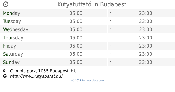
Kutyafuttató
Budapest, Olimpia park
Park
read more
📑
all categories
Accounting
Administrative area level 1
Administrative area level 2
Airport
Amusement park
Aquarium
Art gallery
Atm
Bakery
Bank
Bar
Beauty salon
Bicycle store
Book store
Bowling alley
Bus station
Cafe
Campground
Car dealer
Car rental
Car repair
Car wash
Casino
Cemetery
Church
City hall
Clothing store
Colloquial area
Convenience store
Country
Courthouse
Dentist
Department store
Doctor
Electrician
Electronics store
Embassy
Finance
Fire station
Florist
Food
Funeral home
Furniture store
Gas station
General contractor
Grocery or supermarket
Gym
Hair care
Hardware store
Health
Hindu Temple
Home goods store
Hospital
Insurance agency
Intersection
Jewelry store
Laundry
Lawyer
Library
Light rail station
Liquor store
Local government office
Locality
Locksmith
Lodging
Meal delivery
Meal takeaway
Mosque
Movie rental
Movie theater
Moving company
Museum
Natural feature
Neighborhood
Night club
Painter
Park
Parking
Pet store
Pharmacy
Physiotherapist
Place of worship
Plumber
Point of interest
Police
Political
Post office
Premise
Real estate agency
Restaurant
Roofing contractor
Route
Rv park, camping
School
Shoe store
Shopping mall
Spa
Stadium
Storage
Store
Subpremise
Subway station
Supermarket
Synagogue
Taxi stand
Train station
Transit station
Travel agency
University
Veterinary care
Zoo
administrative area level 3
sublocality level 1
↑