Park nearby Kisbágyoni focipálya
Hungary
Park nearby Kisbágyoni focipálya
Kisbágyoni focipálya
Kisbágyon Magyarország
contacts phone
:
+36
Latitude:
47.8211181
, Longitude:
19.588475
read more
nearest Park
2.53 km
Palotási focipálya
Palotás
Park
read more
3.688 km
Egyházasdengeleg Sportpálya
Egyházasdengeleg, Sport út 24
Park
read more
4.766 km
Héhalomi focipálya
Héhalom
Park
read more
7.214 km
Bujáki focipálya
Buják
Park
read more
8.182 km
I. világháborus emlékmü
Bér
Park
read more
8.275 km
Káponka, Buják
Buják, Külterület
Park
read more
8.298 km
Apci focipálya
Apc
Park
read more
9.367 km
Árpád úti sporttelep
Lőrinci
Park
read more
11.34 km
Petőfibányai focipálya
Petőfibánya
Park
read more
11.868 km
Világháborús, A Bányászat hőseinek, és az1956-os Forradalom Enlékműve
Rózsaszentmárton, Apci út 1
Park
read more
12.701 km
Nagy Koncsur Nyereg
Szurdokpüspöki
Park
read more
12.74 km
Herédi focipálya
Heréd
Park
read more
12.849 km
Erőműi sportpálya
Lőrinci
Park
read more
12.947 km
Pásztói focipálya
Pásztó
Park
read more
13.667 km
Szűcsi focipálya
Szűcsi
Park
read more
14.727 km
Galgagutai focipálya
Galgaguta
Park
read more
14.876 km
Muzsla nyereg
Pásztó
Park
read more
15.355 km
Eleventáj Mūhely
Bercel, Unnamed Road
Park
read more
15.384 km
Gólya Televízió/Gólya Park
Bercel, Gácsi út 25
Park
read more
16.335 km
Honvéd sportpálya
Hatvan
Park
read more
17.617 km
Ecsédi focipálya
Ecséd
Park
read more
18.148 km
ZAGYVA-LIGETI PARKFITNESZ PALYA
Hatvan, bástya utca 10
Park
read more
20.541 km
Galgamácsai focipálya
Galgamácsa
Park
read more
27.894 km
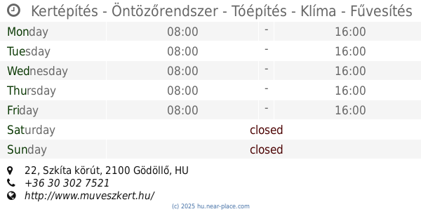
Kertépítés - Öntözőrendszer - Tóépítés - Klíma - Fűvesítés
Gödöllő, Szkíta körút 22
Park
read more
31.257 km
Erzsébet park
Gödöllő
Park
read more
📑
all categories
Accounting
Administrative area level 1
Administrative area level 2
Airport
Amusement park
Aquarium
Art gallery
Atm
Bakery
Bank
Bar
Beauty salon
Bicycle store
Book store
Bowling alley
Bus station
Cafe
Campground
Car dealer
Car rental
Car repair
Car wash
Casino
Cemetery
Church
City hall
Clothing store
Colloquial area
Convenience store
Country
Courthouse
Dentist
Department store
Doctor
Electrician
Electronics store
Embassy
Finance
Fire station
Florist
Food
Funeral home
Furniture store
Gas station
General contractor
Grocery or supermarket
Gym
Hair care
Hardware store
Health
Hindu Temple
Home goods store
Hospital
Insurance agency
Intersection
Jewelry store
Laundry
Lawyer
Library
Light rail station
Liquor store
Local government office
Locality
Locksmith
Lodging
Meal delivery
Meal takeaway
Mosque
Movie rental
Movie theater
Moving company
Museum
Natural feature
Neighborhood
Night club
Painter
Park
Parking
Pet store
Pharmacy
Physiotherapist
Place of worship
Plumber
Point of interest
Police
Political
Post office
Premise
Real estate agency
Restaurant
Roofing contractor
Route
Rv park, camping
School
Shoe store
Shopping mall
Spa
Stadium
Storage
Store
Subpremise
Subway station
Supermarket
Synagogue
Taxi stand
Train station
Transit station
Travel agency
University
Veterinary care
Zoo
administrative area level 3
sublocality level 1
↑