Park nearby GIMEK ZRT
Hungary
Park nearby GIMEK ZRT
GIMEK ZRT
11, Rozália park, 2051, Biatorbágy, HU Hungary
contacts phone
:
+36 23 502 240
website:
www.gimek.hu
Latitude:
47.4758648
, Longitude:
18.8471793
larger map & directions
read more
nearest Park
1.002 km
Feszület-park
Biatorbágy
Park
read more
1.339 km
Biatorbágy Green Heart
Biatorbágy, Fő utca
Park
read more
1.802 km
Fő tér
Biatorbágy
Park
read more
2.344 km
Kolozsvári utcai sportpálya
Biatorbágy
Park
read more
2.733 km
SuperSize Recording Studio
Törökbálint, Ráczug tanya
Park
read more
2.789 km
Almáskert | DomaFarm
Törökbálint, 47.458722, 18.874284
Park
read more
2.789 km
Almáskert | Doma Farm
Törökbálint, 47.458722, 18.874284
Park
read more
3.13 km
Fenyves
Páty, Fenyves utca 1
Park
read more
3.15 km
Nyakas-kő
Biatorbágy
Park
read more
3.263 km
NIPÜF
Páty, 2071, Csonka J. u
Park
read more
3.309 km
Biai vadaszhaz
Biatorbágy
Park
read more
4.148 km
Buda Park
Budaörs, Keleti utca 1
Park
read more
4.72 km
Eisler Mátyás Emlékpark
Páty, 1026.hrsz,, liget utca
Park
read more
5.788 km
Budakeszi Arborétum
Budapest, Erzsébet puszta
Park
read more
6.767 km
Kegyeleti Park - Valla kripta
Törökbálint, Temető köz 7-8
Park
read more
8.534 km
Sándor Móric tér
Herceghalom, Sándor Móric tér
Park
read more
8.681 km
Normafa Kutyaiskola és Életmód Központ
Budapest, Konkoly-Thege Miklós út 27
Park
read more
12.053 km
Brasov Komondor park and nature trail
Budapest, Brassó út 80a
Park
read more
13.199 km
Cankó tér
XXII. kerület
Park
read more
13.236 km
Kéktúra Pecsételőhely
Nagykovácsi, Muflon utca 20
Park
read more
13.693 km
Nyugdíjasok Kertje
Budapest, Fraknó utca 22
Park
read more
14.47 km
Levendulás Park
Budapest, Kanizsai utca 28
Park
read more
14.944 km
Molnár János-barlang
Budapest, Frankel Leó út 48
Park
read more
15.123 km
vörös réteg
Érd
Park
read more
15.207 km
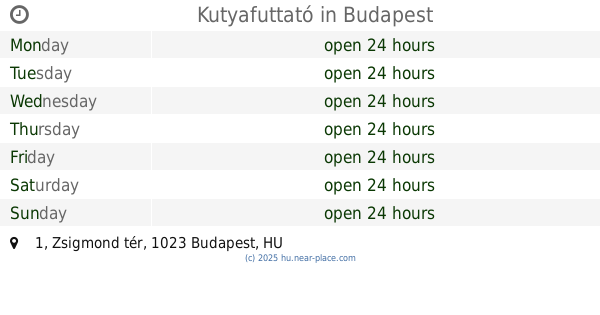
Kutyafuttató
Budapest, Zsigmond tér 1
Park
read more
📑
all categories
Accounting
Administrative area level 1
Administrative area level 2
Airport
Amusement park
Aquarium
Art gallery
Atm
Bakery
Bank
Bar
Beauty salon
Bicycle store
Book store
Bowling alley
Bus station
Cafe
Campground
Car dealer
Car rental
Car repair
Car wash
Casino
Cemetery
Church
City hall
Clothing store
Colloquial area
Convenience store
Country
Courthouse
Dentist
Department store
Doctor
Electrician
Electronics store
Embassy
Finance
Fire station
Florist
Food
Funeral home
Furniture store
Gas station
General contractor
Grocery or supermarket
Gym
Hair care
Hardware store
Health
Hindu Temple
Home goods store
Hospital
Insurance agency
Intersection
Jewelry store
Laundry
Lawyer
Library
Light rail station
Liquor store
Local government office
Locality
Locksmith
Lodging
Meal delivery
Meal takeaway
Mosque
Movie rental
Movie theater
Moving company
Museum
Natural feature
Neighborhood
Night club
Painter
Park
Parking
Pet store
Pharmacy
Physiotherapist
Place of worship
Plumber
Point of interest
Police
Political
Post office
Premise
Real estate agency
Restaurant
Roofing contractor
Route
Rv park, camping
School
Shoe store
Shopping mall
Spa
Stadium
Storage
Store
Subpremise
Subway station
Supermarket
Synagogue
Taxi stand
Train station
Transit station
Travel agency
University
Veterinary care
Zoo
administrative area level 3
sublocality level 1
↑