Park nearby Erdőkertesi focipálya
Coronavirus disease (COVID-19) Situation
confirmed cases
2230232
deaths
49048
Hungary
Park nearby Erdőkertesi focipálya
Erdőkertesi focipálya
Erdőkertes Magyarország
contacts phone
:
+36
Latitude:
47.6652674
, Longitude:
19.3076038
read more
nearest Park
331 m
kézilabda pálya
Erdőkertes
Park
read more
417 m
Szent István park
Erdőkertes
Park
read more
417 m
Szent István Park
Erdőkertes, Fő tér 4
Park
read more
446 m
Erdőkertesi Magyar Munkaszolgálatosok emlékműve
fő utca tó utva
Park
read more
502 m
Utcasajt
Erdőkertes
Park
read more
1.963 km
Veresegyházi főtér
Veresegyház, Fő út 38
Park
read more
2.439 km
Búcsú tér
Veresegyház
Park
read more
2.683 km
Őrbottyáni focipálya
Őrbottyán
Park
read more
2.987 km
ITT park
Őrbottyán
Park
read more
3.052 km
Őrbottyán városközpont
Őrbottyán
Park
read more
3.738 km
Nádasliget Pihenőpark
Veresegyház, Barázda utca 2
Park
read more
3.849 km
Heroes' Square
Őrbottyán, Hősök tere
Park
read more
3.849 km
Hősök tere
Őrbottyán, Hősök tere
Park
read more
6.143 km
Csomádi focipálya
Csomád
Park
read more
7.542 km
Erzsébet park
Gödöllő
Park
read more
9.869 km
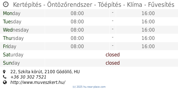
Kertépítés - Öntözőrendszer - Tóépítés - Klíma - Fűvesítés
Gödöllő, Szkíta körút 22
Park
read more
13.277 km
Kincsem Park
Göd, Pesti út 93
Park
read more
13.421 km
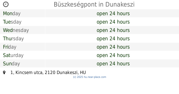
Büszkeségpont
Dunakeszi, Kincsem utca 1
Park
read more
13.566 km
Öntbolt.hu Kft. Dunakeszi Shop
Dunakeszi, Fő út 129
Park
read more
13.582 km
Szent Imre Szobor
Kistarcsa, Batthyány utca 2
Park
read more
13.89 km
Atilla szobor
Dunakeszi, Attila utca
Park
read more
14.769 km
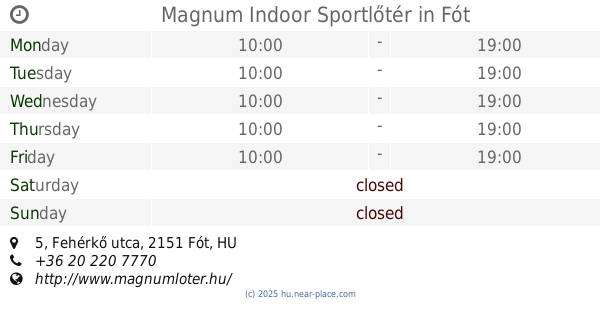
Magnum Indoor Sportlőtér
Fót, 2151, Fehérkő utca 5
Park
read more
16.265 km
Játszótér
IV. kerület
Park
read more
17.906 km
Páskomliget-park
Rákospalota
Park
read more
18.316 km
Városháza park
Budapest Deák F. utca
Park
read more
📑
all categories
Accounting
Administrative area level 1
Administrative area level 2
Airport
Amusement park
Aquarium
Art gallery
Atm
Bakery
Bank
Bar
Beauty salon
Bicycle store
Book store
Bowling alley
Bus station
Cafe
Campground
Car dealer
Car rental
Car repair
Car wash
Casino
Cemetery
Church
City hall
Clothing store
Colloquial area
Convenience store
Country
Courthouse
Dentist
Department store
Doctor
Electrician
Electronics store
Embassy
Finance
Fire station
Florist
Food
Funeral home
Furniture store
Gas station
General contractor
Grocery or supermarket
Gym
Hair care
Hardware store
Health
Hindu Temple
Home goods store
Hospital
Insurance agency
Intersection
Jewelry store
Laundry
Lawyer
Library
Light rail station
Liquor store
Local government office
Locality
Locksmith
Lodging
Meal delivery
Meal takeaway
Mosque
Movie rental
Movie theater
Moving company
Museum
Natural feature
Neighborhood
Night club
Painter
Park
Parking
Pet store
Pharmacy
Physiotherapist
Place of worship
Plumber
Point of interest
Police
Political
Post office
Premise
Real estate agency
Restaurant
Roofing contractor
Route
Rv park, camping
School
Shoe store
Shopping mall
Spa
Stadium
Storage
Store
Subpremise
Subway station
Supermarket
Synagogue
Taxi stand
Train station
Transit station
Travel agency
University
Veterinary care
Zoo
administrative area level 3
sublocality level 1
↑