Park nearby Csővári focipálya
Coronavirus disease (COVID-19) Situation
confirmed cases
2230232
deaths
49048
Hungary
Park nearby Csővári focipálya
Csővári focipálya
Csővár Magyarország
contacts phone
:
+36
Latitude:
47.8110507
, Longitude:
19.3259184
read more
nearest Park
3.554 km
Ezersziget Horgásztó
Nézsa, Táncsics út
Park
read more
3.554 km
Thousand Island Fishing
Nézsa, Táncsics út
Park
read more
4.18 km
Jatszoter
Püspökhatvan, Szabadság utca 103
Park
read more
4.44 km
Acsai focipálya
Acsa
Park
read more
4.574 km
Reviczky-kastély és kastélypark
Nézsa, Szondy út 99
Park
read more
8.329 km
Rádi focipálya
Rád, Május 1. utca
Park
read more
8.51 km
Galgagyörki focipálya
Galgagyörk
Park
read more
10.574 km
Kosdi focipálya
Kosd
Park
read more
13.222 km
Naszály-hegy
Hungary
Park
read more
13.265 km
MTA Ökológiai és Botanikai Kutató Intézet
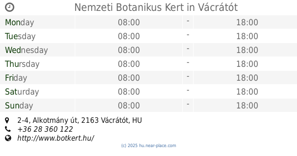
Vácrátót, Alkotmány utca 2-4
Park
read more
13.302 km
National Botanical Garden
Vácrátót, Alkotmány út 2-4
Park
read more
13.302 km
Nemzeti Botanikus Kert
Vácrátót, Alkotmány út 2-4
Park
read more
14.21 km
Csipkés-hegy
Nőtincs
Park
read more
14.242 km
ITT park
Őrbottyán
Park
read more
14.359 km
I. világháborus emlékmü
Bér
Park
read more
14.771 km
Őrbottyán városközpont
Őrbottyán
Park
read more
15.042 km
Hősök tere
Őrbottyán, Hősök tere
Park
read more
15.304 km
I. világháborús emlékmű
Vác, Március 15. tér 7
Park
read more
16.868 km
Sződliget kikötő
Danube
Park
read more
17.201 km
Kapcsolat park
Göd, Kálmán utca 39 2132, Áldás utca 38
Park
read more
17.807 km
Első Profikertész Kft.
Göd, Otthon utca 20
Park
read more
18.666 km
Isten-hegy
Bánk
Park
read more
19.007 km
Lome Store
Rétság, Zrínyi utca 3
Park
read more
19.637 km
Kincsem Park
Göd, Pesti út 93
Park
read more
20.502 km
Homoksziget Beach
Göd
Park
read more
📑
all categories
Accounting
Administrative area level 1
Administrative area level 2
Airport
Amusement park
Aquarium
Art gallery
Atm
Bakery
Bank
Bar
Beauty salon
Bicycle store
Book store
Bowling alley
Bus station
Cafe
Campground
Car dealer
Car rental
Car repair
Car wash
Casino
Cemetery
Church
City hall
Clothing store
Colloquial area
Convenience store
Country
Courthouse
Dentist
Department store
Doctor
Electrician
Electronics store
Embassy
Finance
Fire station
Florist
Food
Funeral home
Furniture store
Gas station
General contractor
Grocery or supermarket
Gym
Hair care
Hardware store
Health
Hindu Temple
Home goods store
Hospital
Insurance agency
Intersection
Jewelry store
Laundry
Lawyer
Library
Light rail station
Liquor store
Local government office
Locality
Locksmith
Lodging
Meal delivery
Meal takeaway
Mosque
Movie rental
Movie theater
Moving company
Museum
Natural feature
Neighborhood
Night club
Painter
Park
Parking
Pet store
Pharmacy
Physiotherapist
Place of worship
Plumber
Point of interest
Police
Political
Post office
Premise
Real estate agency
Restaurant
Roofing contractor
Route
Rv park, camping
School
Shoe store
Shopping mall
Spa
Stadium
Storage
Store
Subpremise
Subway station
Supermarket
Synagogue
Taxi stand
Train station
Transit station
Travel agency
University
Veterinary care
Zoo
administrative area level 3
sublocality level 1
↑