Night club nearby Tótvázsonyi Ifjúsági Egyesület
Hungary
Night club nearby Tótvázsonyi Ifjúsági Egyesület
Tótvázsonyi Ifjúsági Egyesület
Tótvázsony, Magyar utca 101 Ungarn
contacts phone
:
+36
Latitude:
47.0079549
, Longitude:
17.7873508
read more
nearest Night club
7.888 km
Levendula szüret Kakashegy
Vászoly
Night club
read more
8.173 km
Sufni pub
Balatonfüred, Somogyi utca 7
Night club
read more
9.418 km
Cseles Kelepce
Balatonfüred, Horváth Mihály utca 23
Night club
read more
9.434 km
SunCity
Balatonfüred
Night club
read more
9.601 km
Szallas
Balatonfüred, Petőfi Sándor utca 5
Night club
read more
10.159 km
Vitrolásbérlés /kötélhajó/
Balatonfüred
Night club
read more
10.283 km
Tagore Sétány
Balatonfüred, Tagore sétány
Night club
read more
10.353 km
Oxoo Electric
Balatonfüred, Tagore sétány 1
Night club
read more
12.752 km
Rock Ranch Bánd
Bánd, Petőfi Sándor utca 73
Night club
read more
12.833 km
ÉletMagHáz
Veszprém, Dózsa György utca 23
Night club
read more
12.913 km
Termeloi borozo - hovirag
Tihany, Váralja utca 23
Night club
read more
13.026 km
LaserBase Veszprém
Veszprém, Völgyhíd tér 1
Night club
read more
13.131 km
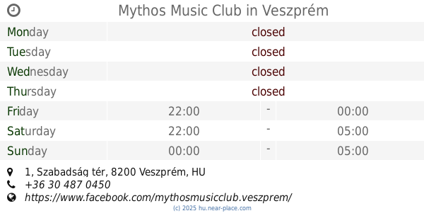
Mythos Music Club
Veszprém, Szabadság tér 1
Night club
read more
13.202 km
Közgáz Udvar
Veszprém, Vár utca 18
Night club
read more
13.622 km
Bagoly Kocsma
Veszprém, Aranyoskút utca 7
Night club
read more
14.043 km
Fenyves Söröző
Szentantalfa, Szikla utca
Night club
read more
14.064 km
Faház klub
Herend, Kossuth Lajos utca 127
Night club
read more
14.156 km
Simon Borozó
Alsóörs, Május 1. utca 7
Night club
read more
14.889 km
Dingi Vitorláskölcsönző
Alsóörs
Night club
read more
15.06 km
Társasjátékvölgy
Kapolcs
Night club
read more
15.18 km
FolkUdvar
Kapolcs, Kossuth utca 12
Night club
read more
17.737 km
Music Pavilion - Zamárdi
Zamárdi, Szabadstrand, Bácskay utca
Night club
read more
17.774 km
Balaton Free beach
Törökszentmiklós, 46 17
Night club
read more
19.037 km
Bódis Residenszoá
Zamárdi, Dessewffy utca 74
Night club
read more
20.266 km
Tombor István Pincéje
Köveskál
Night club
read more
📑
all categories
Accounting
Administrative area level 1
Administrative area level 2
Airport
Amusement park
Aquarium
Art gallery
Atm
Bakery
Bank
Bar
Beauty salon
Bicycle store
Book store
Bowling alley
Bus station
Cafe
Campground
Car dealer
Car rental
Car repair
Car wash
Casino
Cemetery
Church
City hall
Clothing store
Colloquial area
Convenience store
Country
Courthouse
Dentist
Department store
Doctor
Electrician
Electronics store
Embassy
Finance
Fire station
Florist
Food
Funeral home
Furniture store
Gas station
General contractor
Grocery or supermarket
Gym
Hair care
Hardware store
Health
Hindu Temple
Home goods store
Hospital
Insurance agency
Intersection
Jewelry store
Laundry
Lawyer
Library
Light rail station
Liquor store
Local government office
Locality
Locksmith
Lodging
Meal delivery
Meal takeaway
Mosque
Movie rental
Movie theater
Moving company
Museum
Natural feature
Neighborhood
Night club
Painter
Park
Parking
Pet store
Pharmacy
Physiotherapist
Place of worship
Plumber
Point of interest
Police
Political
Post office
Premise
Real estate agency
Restaurant
Roofing contractor
Route
Rv park, camping
School
Shoe store
Shopping mall
Spa
Stadium
Storage
Store
Subpremise
Subway station
Supermarket
Synagogue
Taxi stand
Train station
Transit station
Travel agency
University
Veterinary care
Zoo
administrative area level 3
sublocality level 1
↑