Night club nearby Little Star Photo
Coronavirus disease (COVID-19) Situation
confirmed cases
2230232
deaths
49048
Hungary
Night club nearby Little Star Photo
Little Star Photo
Isaszeg, Roham utca 1-17 Magyarország
contacts phone
:
+36
Latitude:
47.5275285
, Longitude:
19.3986801
read more
nearest Night club
251 m
Csatangoló tánccsoport
Isaszeg
Night club
read more
1.549 km
Agárpálya, Isaszeg
Isaszeg, 3102
Night club
read more
1.604 km
Hadak Útja Lovas Egyesület
Isaszeg
Night club
read more
4.076 km
Patakpart Gödöllő
Gödöllő, 3103
Night club
read more
5.756 km
Díszállat Horgászcikk Pécel Baross u.2
Pécel, Baross utca 2
Night club
read more
8.499 km
Uriember park.
Nagytarcsa, Szőlő utca 10
Night club
read more
8.693 km
Abaújtej K.V.
Gödöllő, Kühne Ede utca 1
Night club
read more
8.724 km
Red & Black Club
Gödöllő, Szabadság út 16
Night club
read more
8.94 km
Játszótér
Budapest, Göcsej utca 29
Night club
read more
9.339 km
Nagytarcsa Felsőrét Lakópark
Nagytarcsa, Kökény utca
Night club
read more
9.711 km
Zrínyi Söröző - Borozó
Budapest, Zrínyi utca 86
Night club
read more
10.172 km
Club Blue
Kerepes, Szabadság út 1
Night club
read more
10.289 km
Kerepesi tanösvény
Kerepes, Unnamed Road
Night club
read more
10.326 km
VL Stúdió Kft.
Gödöllő, Kenyérgyári utca 4
Night club
read more
10.376 km
Makrai “Ales” Tibor pihenő
Kerepes, Szár-hegy
Night club
read more
11.249 km
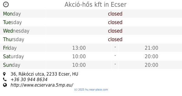
Akció-hős kft
Ecser, Rákóczi utca 36
Night club
read more
11.401 km
Tanyasi Horgásztó és Vendégház
Mende
Night club
read more
11.463 km
Rákosmente - Nyilastábla
Budapest
Night club
read more
11.63 km
Csutortoki Jatszoter
Gyömrő, Klapka utca 50
Night club
read more
14.06 km
Mogyoródi borospincék
Mogyoród, Somlói út 9
Night club
read more
14.372 km
Hoppááá pub
Budapest, Baross utca 84
Night club
read more
15.811 km
Póni Kaland Park
Veresegyház
Night club
read more
17.038 km
Kónya Tó
Tura, Puskin tér 23-24
Night club
read more
18.123 km
Cirkusz Tér.
Vecsés, Széchenyi utca 10
Night club
read more
19.602 km
Bogi lovarda
Almáskert
Night club
read more
📑
all categories
Accounting
Administrative area level 1
Administrative area level 2
Airport
Amusement park
Aquarium
Art gallery
Atm
Bakery
Bank
Bar
Beauty salon
Bicycle store
Book store
Bowling alley
Bus station
Cafe
Campground
Car dealer
Car rental
Car repair
Car wash
Casino
Cemetery
Church
City hall
Clothing store
Colloquial area
Convenience store
Country
Courthouse
Dentist
Department store
Doctor
Electrician
Electronics store
Embassy
Finance
Fire station
Florist
Food
Funeral home
Furniture store
Gas station
General contractor
Grocery or supermarket
Gym
Hair care
Hardware store
Health
Hindu Temple
Home goods store
Hospital
Insurance agency
Intersection
Jewelry store
Laundry
Lawyer
Library
Light rail station
Liquor store
Local government office
Locality
Locksmith
Lodging
Meal delivery
Meal takeaway
Mosque
Movie rental
Movie theater
Moving company
Museum
Natural feature
Neighborhood
Night club
Painter
Park
Parking
Pet store
Pharmacy
Physiotherapist
Place of worship
Plumber
Point of interest
Police
Political
Post office
Premise
Real estate agency
Restaurant
Roofing contractor
Route
Rv park, camping
School
Shoe store
Shopping mall
Spa
Stadium
Storage
Store
Subpremise
Subway station
Supermarket
Synagogue
Taxi stand
Train station
Transit station
Travel agency
University
Veterinary care
Zoo
administrative area level 3
sublocality level 1
↑