Night club nearby Herendi Bányató
Hungary
Night club nearby Herendi Bányató
Herendi Bányató
Herend Hungary
contacts phone
:
+36
Latitude:
47.1502816
, Longitude:
17.7273862
read more
nearest Night club
2.736 km
Faház klub
Herend, Kossuth Lajos utca 127
Night club
read more
5.044 km
Rock Ranch Bánd
Bánd, Petőfi Sándor utca 73
Night club
read more
8.601 km
Pinto Ranch
Bakonybél
Night club
read more
9.87 km
Blue Belfegor
Ùrkùt, Ràkòczi U 41
Night club
read more
11.232 km
Motocross & Enduro Park Ajka
Ajkarendek, Motocross & Enduro Park
Night club
read more
12.745 km
Smaragd Büfé
Tüskevár, Vasútállomás utca
Night club
read more
13.496 km
Nagy László VKSZK Ajka
Ajka
Night club
read more
13.945 km
LaserBase Veszprém
Veszprém, Völgyhíd tér 1
Night club
read more
14.219 km
Légvárvarázs
Ajka, Frankel Leó 20. utca
Night club
read more
14.253 km
Bagoly Kocsma
Veszprém, Aranyoskút utca 7
Night club
read more
14.604 km
Közgáz Udvar
Veszprém, Vár utca 18
Night club
read more
14.636 km
ÉletMagHáz
Veszprém, Dózsa György utca 23
Night club
read more
14.955 km
MisztIQum - Szabadulós Játék
Veszprém, Jókai Mór utca 6, Óváros tér 1.
Night club
read more
15.05 km
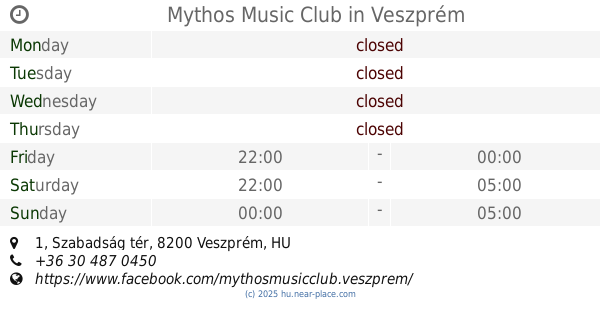
Mythos Music Club
Veszprém, Szabadság tér 1
Night club
read more
15.17 km
Club Cash Box
Veszprém, Bagolyvári u.
Night club
read more
15.637 km
Rózsabokor Presszó
Veszprém, Egry József utca 27
Night club
read more
15.637 km
Bush Rose Cafe
Veszprém, Egry József utca 27
Night club
read more
16.298 km
Alfa Biliárd Bár
Veszprém, Nyerges utca 6
Night club
read more
23.636 km
Társasjátékvölgy
Kapolcs
Night club
read more
23.759 km
Sufni pub
Balatonfüred, Somogyi utca 7
Night club
read more
24.757 km
Cseles Kelepce
Balatonfüred, Horváth Mihály utca 23
Night club
read more
25.322 km
Oxoo Electric
Balatonfüred, Tagore sétány 1
Night club
read more
25.369 km
Vitrolásbérlés /kötélhajó/
Balatonfüred
Night club
read more
27.463 km
Nekünk Nyolc
Pápa, Nyolcadik utca 1
Night club
read more
30.662 km
Szápári horgásztó
Szápár
Night club
read more
📑
all categories
Accounting
Administrative area level 1
Administrative area level 2
Airport
Amusement park
Aquarium
Art gallery
Atm
Bakery
Bank
Bar
Beauty salon
Bicycle store
Book store
Bowling alley
Bus station
Cafe
Campground
Car dealer
Car rental
Car repair
Car wash
Casino
Cemetery
Church
City hall
Clothing store
Colloquial area
Convenience store
Country
Courthouse
Dentist
Department store
Doctor
Electrician
Electronics store
Embassy
Finance
Fire station
Florist
Food
Funeral home
Furniture store
Gas station
General contractor
Grocery or supermarket
Gym
Hair care
Hardware store
Health
Hindu Temple
Home goods store
Hospital
Insurance agency
Intersection
Jewelry store
Laundry
Lawyer
Library
Light rail station
Liquor store
Local government office
Locality
Locksmith
Lodging
Meal delivery
Meal takeaway
Mosque
Movie rental
Movie theater
Moving company
Museum
Natural feature
Neighborhood
Night club
Painter
Park
Parking
Pet store
Pharmacy
Physiotherapist
Place of worship
Plumber
Point of interest
Police
Political
Post office
Premise
Real estate agency
Restaurant
Roofing contractor
Route
Rv park, camping
School
Shoe store
Shopping mall
Spa
Stadium
Storage
Store
Subpremise
Subway station
Supermarket
Synagogue
Taxi stand
Train station
Transit station
Travel agency
University
Veterinary care
Zoo
administrative area level 3
sublocality level 1
↑