Gym nearby Robimasszazs
Hungary
Gym nearby Robimasszazs
Robimasszazs
18, Reitter Ferenc utca, 1131, Budapest, HU Magyarország
contacts phone
:
+36 20 252 2944
Latitude:
47.5264084
, Longitude:
19.0827225
larger map & directions
read more
nearest Gym
227 m
Chili Fitness 3- Konditerem, Személyi edzés, Személyi edzők, Masszázs
Budapest, Szegedi út 56
Gym
read more
303 m
Jóganesha
Budapest, Lehel utca 61
Gym
read more
358 m
Predator Gym
Budapest, 1135, Lehel utca 70
Gym
read more
462 m
Angelfit E-fit
Budapest, Csata utca 26
Gym
read more
462 m
E-fit Angelfit
Budapest, Csata utca 26
Gym
read more
558 m
Colibri Jóga - Angyalföld
Budapest, Kartács utca 12/B.
Gym
read more
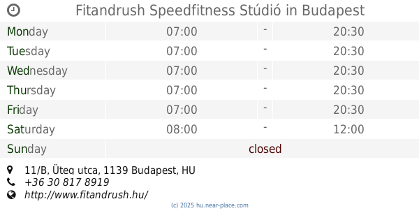
568 m
Fitandrush Speedfitness Stúdió
Budapest, Üteg utca 11/B
Gym
read more
574 m
Airyoga Hungary
Budapest, Bajcsy-Zsilinszky út 31
Gym
read more
688 m
Bvsc Asztalitenisz
Budapest, Teleki Blanka utca 6
Gym
read more
688 m
BVSC Table Tennis
Budapest, Teleki Blanka utca 6
Gym
read more
824 m
Beauty & Body Szalon
Budapest, 1135, Párta köz 6
Gym
read more
834 m
EMS Revolution Fitness Stúdió
Budapest, Frangepán köz 17
Gym
read more
861 m
Hungarian Mecca Of Body Building
Budapest, Béke utca 23
Gym
read more
865 m
CrossFit Bloodfit
Budapest, Tüzér utca 56
Gym
read more
869 m
혼베이드
Budapest, Tüzér utca 56
Gym
read more
906 m
Fitness Cardio Training
Budapest, Béke utca 21-29
Gym
read more
906 m
BodyCode Functional Training
Budapest, Béke utca 21-29
Gym
read more
941 m
Szabadtéri Fitness Park
Budapest, Gidófalvy Lajos utca
Gym
read more
973 m
Giants Gym
Budapest, Fáy utca 65a
Gym
read more
1.055 km
Rx Nation Budapest
Budapest, Kassák Lajos utca 78
Gym
read more
1.055 km
Mázsaház
Budapest, Kassák Lajos utca 78
Gym
read more
1.056 km
InfraTrainer13
Fáy u. 45. 3. em. (Oxygen Wellness Fáy
Gym
read more
1.115 km
TopForma Speedfitness 13.kerület
Budapest, Gömb utca 2b
Gym
read more
1.162 km
B4 Fitness
Budapest, Dózsa György út 128
Gym
read more
1.799 km
outdoor gym
Budapest, Vizafogó sétány 6
Gym
read more
📑
all categories
Accounting
Administrative area level 1
Administrative area level 2
Airport
Amusement park
Aquarium
Art gallery
Atm
Bakery
Bank
Bar
Beauty salon
Bicycle store
Book store
Bowling alley
Bus station
Cafe
Campground
Car dealer
Car rental
Car repair
Car wash
Casino
Cemetery
Church
City hall
Clothing store
Colloquial area
Convenience store
Country
Courthouse
Dentist
Department store
Doctor
Electrician
Electronics store
Embassy
Finance
Fire station
Florist
Food
Funeral home
Furniture store
Gas station
General contractor
Grocery or supermarket
Gym
Hair care
Hardware store
Health
Hindu Temple
Home goods store
Hospital
Insurance agency
Intersection
Jewelry store
Laundry
Lawyer
Library
Light rail station
Liquor store
Local government office
Locality
Locksmith
Lodging
Meal delivery
Meal takeaway
Mosque
Movie rental
Movie theater
Moving company
Museum
Natural feature
Neighborhood
Night club
Painter
Park
Parking
Pet store
Pharmacy
Physiotherapist
Place of worship
Plumber
Point of interest
Police
Political
Post office
Premise
Real estate agency
Restaurant
Roofing contractor
Route
Rv park, camping
School
Shoe store
Shopping mall
Spa
Stadium
Storage
Store
Subpremise
Subway station
Supermarket
Synagogue
Taxi stand
Train station
Transit station
Travel agency
University
Veterinary care
Zoo
administrative area level 3
sublocality level 1
↑