Gas station nearby Shell
Hungary
Gas station nearby Shell
Shell
6, Pesti út, 1173, Budapest, HU Węgry
contacts phone
:
+36 1 256 0175
website:
find.shell.com
Latitude:
47.4845725
, Longitude:
19.23152
larger map & directions
read more
nearest Gas station
298 m
OMV Töltőállomás
Budapest, Pesti út 16-18
Gas station
read more
308 m
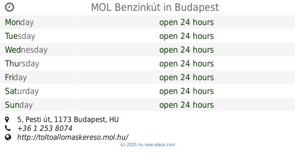
MOL Benzinkút
Budapest, Pesti út 5
Gas station
read more
605 m
Lukoil
Budapest, Pesti út 2
Gas station
read more
1.171 km
MOL Benzinkút
Budapest, Cinkotai út
Gas station
read more
1.43 km
Magán - Budapest - Táncsics Mihály u.
Budapest, Táncsics Mihály út 47
Gas station
read more
1.54 km
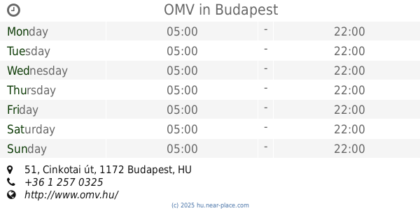
OMV
Budapest, Cinkotai út 51
Gas station
read more
1.54 km
OMV Töltőállomás
Budapest, Cinkotai út 51
Gas station
read more
2.417 km
OIL! - Budapest - Keresztúri út
Budapest, Keresztúri út 208
Gas station
read more
2.562 km
OMV
Budapest, Rákóczi Ferenc utca 189
Gas station
read more
2.562 km
OMV Töltőállomás
Budapest, Rákóczi Ferenc utca 189
Gas station
read more
2.864 km
Shell
Budapest, Pesti út 273C
Gas station
read more
3.393 km
Lukoil
Budapest, Pesti út 237g
Gas station
read more
3.891 km
OMV Töltőállomás
Budapest, Szabadföldi u. 1
Gas station
read more
4.169 km
MOL Benzinkút
Budapest, Veres Péter út 105-107
Gas station
read more
4.182 km
12403 sz. MOL töltőállomás
Budapest, 107, Veres Péter út 105
Gas station
read more
4.338 km
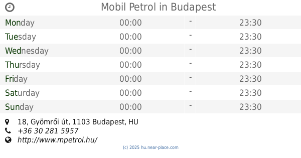
Mobil Petrol
Budapest, Gyömrői út 18
Gas station
read more
4.689 km
BGW Autómosó
Nagytarcsa, Naplás út 1
Gas station
read more
4.69 km
BGW
Nagytarcsa, Naplás út 1
Gas station
read more
4.69 km
BGW CNG Töltőállomás
Nagytarcsa, Naplás út 1
Gas station
read more
4.694 km
CNG töltőállomás
Nagytarcsa, Naplás út
Gas station
read more
4.807 km
AVIA
Nagytarcsa, 3102
Gas station
read more
5.24 km
Benzinkút
Budapest, Arany János utca 55
Gas station
read more
5.307 km
OMV Töltőállomás
Budapest, Haladás utca 39
Gas station
read more
5.307 km
OMV
Budapest, Haladás utca 39
Gas station
read more
5.438 km
MOL Benzinkút
Budapest, Arany J. u. 106.
Gas station
read more
📑
all categories
Accounting
Administrative area level 1
Administrative area level 2
Airport
Amusement park
Aquarium
Art gallery
Atm
Bakery
Bank
Bar
Beauty salon
Bicycle store
Book store
Bowling alley
Bus station
Cafe
Campground
Car dealer
Car rental
Car repair
Car wash
Casino
Cemetery
Church
City hall
Clothing store
Colloquial area
Convenience store
Country
Courthouse
Dentist
Department store
Doctor
Electrician
Electronics store
Embassy
Finance
Fire station
Florist
Food
Funeral home
Furniture store
Gas station
General contractor
Grocery or supermarket
Gym
Hair care
Hardware store
Health
Hindu Temple
Home goods store
Hospital
Insurance agency
Intersection
Jewelry store
Laundry
Lawyer
Library
Light rail station
Liquor store
Local government office
Locality
Locksmith
Lodging
Meal delivery
Meal takeaway
Mosque
Movie rental
Movie theater
Moving company
Museum
Natural feature
Neighborhood
Night club
Painter
Park
Parking
Pet store
Pharmacy
Physiotherapist
Place of worship
Plumber
Point of interest
Police
Political
Post office
Premise
Real estate agency
Restaurant
Roofing contractor
Route
Rv park, camping
School
Shoe store
Shopping mall
Spa
Stadium
Storage
Store
Subpremise
Subway station
Supermarket
Synagogue
Taxi stand
Train station
Transit station
Travel agency
University
Veterinary care
Zoo
administrative area level 3
sublocality level 1
↑