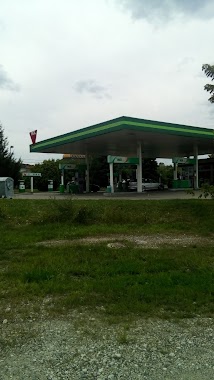
Gas station nearby Omv
Coronavirus disease (COVID-19) Situation
confirmed cases
2230232
deaths
49048
Hungary
Gas station nearby Omv
Omv
Ózd, 3, Brassói út Magyarország
contacts phone
:
+36
Latitude:
48.2214275
, Longitude:
20.2734822
read more
nearest Gas station
4 m
OMV Töltőállomás
Ózd, Brassói út 5
Gas station
read more
4 m
OMV
Ózd, Brassói út 5
Gas station
read more
317 m
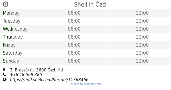
Shell
Ózd, Brassói út 3
Gas station
read more
902 m
MOL
Ózd, Vasvár út (25 -ös út)
Gas station
read more
902 m
MOL Gas station
Ózd, Vasvár út (25 -ös út)
Gas station
read more
1.048 km
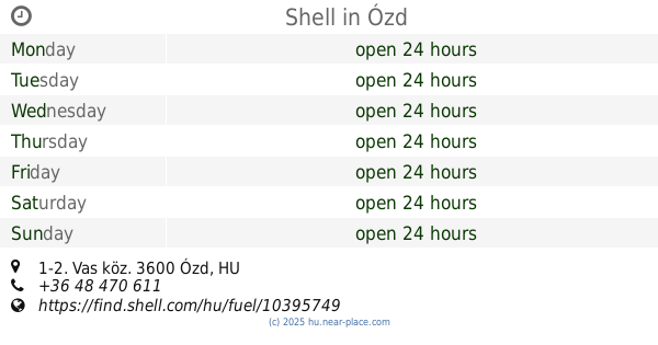
Shell
Ózd, Vas köz 1-2
Gas station
read more
13.681 km
MOL Benzinkút
Putnok, Bajcsy-Zsilinszky út 48
Gas station
read more
13.687 km
MOL Benzinkút
3630 Putnok, Országút
Gas station
read more
15.727 km
OMV Töltőállomás
Dorog, hrsz. 0279 8
Gas station
read more
16.209 km
MOL Szilvásvárad
Szilvásvárad, Egri út 34
Gas station
read more
16.268 km
H2O Autómosó és Benzinkút Dédestapolcsány
Dédestapolcsány, 2506
Gas station
read more
21.841 km
Váradi Pince
Vadna
Gas station
read more
23.987 km
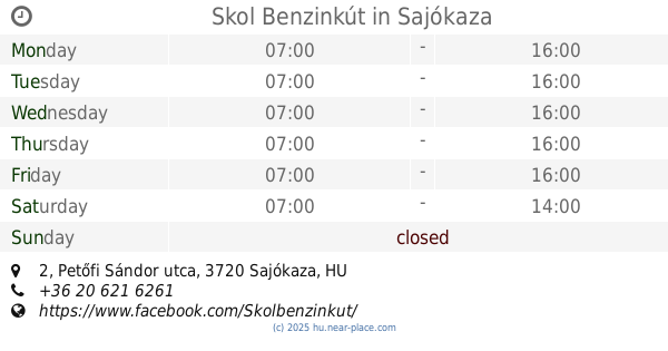
Skol Benzinkút
Sajókaza, Petőfi Sándor utca 2
Gas station
read more
26.095 km
MOL Benzinkút
Pétervására, Orgona utca 6
Gas station
read more
27.865 km
MOL
Kazincbarcika, Múcsonyi út
Gas station
read more
34.068 km
MOL benzinkút
Edelény, Szentpéteri út 2
Gas station
read more
34.861 km
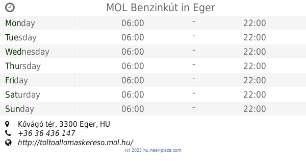
MOL Benzinkút
Eger, Kővágó tér
Gas station
read more
38.544 km
26-os Út Miskolci Kivezető
Szirmabesenyő
Gas station
read more
38.885 km
Shell
Eger, Rákóczi Ferenc u 95
Gas station
read more
39.766 km
MOL Töltőállomás
Eger, Mátyás király út
Gas station
read more
42.887 km
MOL Benzinkút
Miskolc, Pesti út II. (kijövő)
Gas station
read more
43.363 km
AVIA
Miskolc, Miskolci út, 0235/72 hrsz.
Gas station
read more
44.119 km
Shell
Miskolc, Fo út 3, Felsozsolcai Korforg
Gas station
read more
44.937 km
MOL Benzinkút
Felsőzsolca, 3. sz. főút hrsz. 2034/14
Gas station
read more
47.906 km
Teletank Kft.
Bükkábrány, Sályi út 2
Gas station
read more
📑
all categories
Accounting
Administrative area level 1
Administrative area level 2
Airport
Amusement park
Aquarium
Art gallery
Atm
Bakery
Bank
Bar
Beauty salon
Bicycle store
Book store
Bowling alley
Bus station
Cafe
Campground
Car dealer
Car rental
Car repair
Car wash
Casino
Cemetery
Church
City hall
Clothing store
Colloquial area
Convenience store
Country
Courthouse
Dentist
Department store
Doctor
Electrician
Electronics store
Embassy
Finance
Fire station
Florist
Food
Funeral home
Furniture store
Gas station
General contractor
Grocery or supermarket
Gym
Hair care
Hardware store
Health
Hindu Temple
Home goods store
Hospital
Insurance agency
Intersection
Jewelry store
Laundry
Lawyer
Library
Light rail station
Liquor store
Local government office
Locality
Locksmith
Lodging
Meal delivery
Meal takeaway
Mosque
Movie rental
Movie theater
Moving company
Museum
Natural feature
Neighborhood
Night club
Painter
Park
Parking
Pet store
Pharmacy
Physiotherapist
Place of worship
Plumber
Point of interest
Police
Political
Post office
Premise
Real estate agency
Restaurant
Roofing contractor
Route
Rv park, camping
School
Shoe store
Shopping mall
Spa
Stadium
Storage
Store
Subpremise
Subway station
Supermarket
Synagogue
Taxi stand
Train station
Transit station
Travel agency
University
Veterinary care
Zoo
administrative area level 3
sublocality level 1
↑