Gas station nearby OMV Filling Station
Coronavirus disease (COVID-19) Situation
confirmed cases
2230232
deaths
49048
Hungary
Gas station nearby OMV Filling Station
OMV Filling Station
Kecskemét, Kecskemét-Katonatelep, Ceglédi út Hungary
contacts phone
:
+36
Latitude:
46.961312
, Longitude:
19.725677
read more
nearest Gas station
2.903 km
ENVI-METRO
Kecskemét, 236, Úrrét
Gas station
read more
2.903 km
ENVI-METRO Kecskemét
Kecskemét, 236, Úrrét
Gas station
read more
5.516 km
Shell benzinkút
Kecskemét, Bethlen körút 57-61
Gas station
read more
5.516 km
Shell
Kecskemét, Bethlen körút 57-61
Gas station
read more
5.708 km
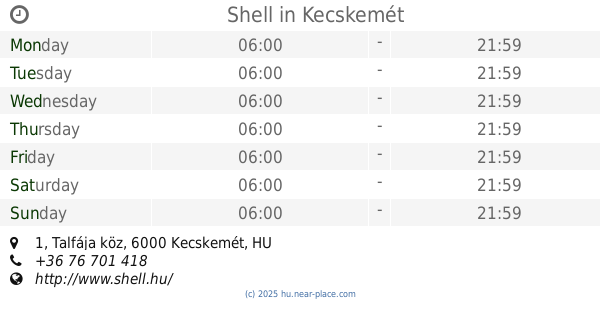
Shell
Kecskemét, Talfája köz 1
Gas station
read more
5.711 km
OMV Töltőállomás
Kecskemét, Budai utca
Gas station
read more
5.711 km
Shell
Kecskemét, Talfája tanya 1
Gas station
read more
5.756 km
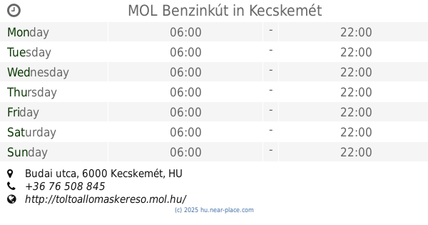
MOL Benzinkút
Kecskemét, Budai utca
Gas station
read more
5.926 km
Agip
Kecskemét, Jókai utca 44
Gas station
read more
5.931 km
Benzinkút
Kecskemét, Széchenyiváros
Gas station
read more
8.701 km
Cng Töltőállomás
Kecskemét, Szegedi út 88
Gas station
read more
8.954 km
Shell
Kecskemét, Szegedi út, 50, Kiskunfélegyházai út
Gas station
read more
10.021 km
OMV Töltőállomás
Nagykőrös, Ceglédi út 256
Gas station
read more
10.338 km
OMV Töltőállomás
Kecskemét, Dunaföldvári út 4
Gas station
read more
10.562 km
J&T Benzinkút
Kecskemét, Barátság utca 2
Gas station
read more
11.237 km
Petro-Canada
Kecskemét
Gas station
read more
11.253 km
AS24 Tankservice GmbH
Kecskemét
Gas station
read more
11.253 km
AS24
Kecskemét
Gas station
read more
13.11 km
Mol M5
Kecskemét, mol benzinkút, M5
Gas station
read more
13.46 km
MOL Benzinkút
Kecskemét, M5 autópálya jobb
Gas station
read more
15.126 km
Shell
Lajosmizse, Lajosmizsei pihenő M5, E75, Autopalya 67. km Nyugat
Gas station
read more
15.236 km
KÉRI OIL
Szentkirály
Gas station
read more
15.283 km
Époil Kft
Kocsér, Szabadság utca
Gas station
read more
16.26 km
MOL Benzinkút
Lajosmizse, 50.sz.út jobb oldal
Gas station
read more
16.26 km
Mol töltőállomás
Lajosmizse, 50.sz.út jobb oldal
Gas station
read more
📑
all categories
Accounting
Administrative area level 1
Administrative area level 2
Airport
Amusement park
Aquarium
Art gallery
Atm
Bakery
Bank
Bar
Beauty salon
Bicycle store
Book store
Bowling alley
Bus station
Cafe
Campground
Car dealer
Car rental
Car repair
Car wash
Casino
Cemetery
Church
City hall
Clothing store
Colloquial area
Convenience store
Country
Courthouse
Dentist
Department store
Doctor
Electrician
Electronics store
Embassy
Finance
Fire station
Florist
Food
Funeral home
Furniture store
Gas station
General contractor
Grocery or supermarket
Gym
Hair care
Hardware store
Health
Hindu Temple
Home goods store
Hospital
Insurance agency
Intersection
Jewelry store
Laundry
Lawyer
Library
Light rail station
Liquor store
Local government office
Locality
Locksmith
Lodging
Meal delivery
Meal takeaway
Mosque
Movie rental
Movie theater
Moving company
Museum
Natural feature
Neighborhood
Night club
Painter
Park
Parking
Pet store
Pharmacy
Physiotherapist
Place of worship
Plumber
Point of interest
Police
Political
Post office
Premise
Real estate agency
Restaurant
Roofing contractor
Route
Rv park, camping
School
Shoe store
Shopping mall
Spa
Stadium
Storage
Store
Subpremise
Subway station
Supermarket
Synagogue
Taxi stand
Train station
Transit station
Travel agency
University
Veterinary care
Zoo
administrative area level 3
sublocality level 1
↑