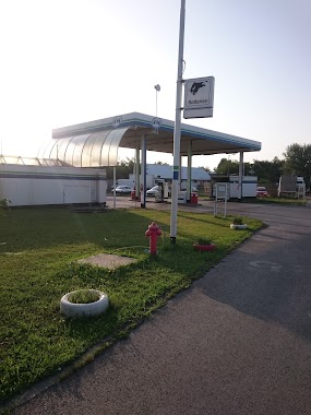
Gas station nearby Magán - Tököl
Coronavirus disease (COVID-19) Situation
confirmed cases
2230232
deaths
49048
Hungary
Gas station nearby Magán - Tököl
Magán - Tököl
4, Ledina dűlő, 2316, Tököl, HU Magyarország
contacts phone
:
+36 62 447 9153
Latitude:
47.3152453
, Longitude:
18.9775331
larger map & directions
read more
nearest Gas station
2 m
Avia benzinkút
Tököl
Gas station
read more
12 m
4M Benzinkút
Tököl, Ledina dűlő 4
Gas station
read more
1.014 km
MOL
Tököl, Csépi út 29
Gas station
read more
2.67 km
MOL Benzinkút
Szigethalom, Petőfi utca 64
Gas station
read more
2.67 km
MOL
Szigethalom, Petőfi utca 64
Gas station
read more
2.959 km
Oplus
Szigetszentmiklós, Gyári út 45
Gas station
read more
2.987 km
Envi
Tököl, Hermina u., 5101
Gas station
read more
3.249 km
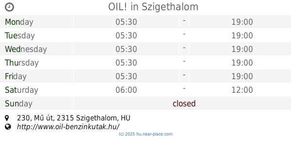
OIL!
Szigethalom, Mű út 230
Gas station
read more
3.562 km
Westbridge
Tököl, 2311 Tököl Repülőtér
Gas station
read more
3.562 km
West Bridge
Tököl, 2311 Tököl Repülőtér
Gas station
read more
3.892 km
Magán - Szigetszentmiklós
Szigetszentmiklós, Gyári út 4
Gas station
read more
4.185 km
Blue Benzinkút
Százhalombatta, Erőmű út 1
Gas station
read more
4.577 km
OMV Töltőállomás
Szigetszentmiklós, Gyári út 3237 hrsz.
Gas station
read more
4.578 km
Castrol
Dunavarsány
Gas station
read more
4.633 km
Sziszi Töltőállomás
Halásztelek, II. Rákóczi Ferenc út 29/A
Gas station
read more
4.802 km
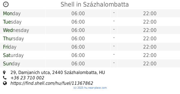
Shell
Százhalombatta, Damjanich utca 29
Gas station
read more
7.521 km
MOL Benzinkút
Dunaharaszti, Fő út
Gas station
read more
7.567 km
Shell
Érd, Budafoki út 2-4
Gas station
read more
7.649 km
Lukoil
Érd, Budafoki út 5
Gas station
read more
9.145 km
Magán - Érd
Érd, Harangvirág utca 1
Gas station
read more
9.204 km
AVIA
Érd, Kossuth Lajos utca 82
Gas station
read more
14.621 km
Diesel Kut
Budapest, Repülőtéri út 6
Gas station
read more
15.774 km
Benzinkút
Bugyi, Kossuth Lajos utca 86
Gas station
read more
15.806 km
MOL Benzinkút
Budapest, Hunyadi János út 2
Gas station
read more
18.239 km
OMV Töltőállomás
Budapest, Nagykőrösi út 349
Gas station
read more
📑
all categories
Accounting
Administrative area level 1
Administrative area level 2
Airport
Amusement park
Aquarium
Art gallery
Atm
Bakery
Bank
Bar
Beauty salon
Bicycle store
Book store
Bowling alley
Bus station
Cafe
Campground
Car dealer
Car rental
Car repair
Car wash
Casino
Cemetery
Church
City hall
Clothing store
Colloquial area
Convenience store
Country
Courthouse
Dentist
Department store
Doctor
Electrician
Electronics store
Embassy
Finance
Fire station
Florist
Food
Funeral home
Furniture store
Gas station
General contractor
Grocery or supermarket
Gym
Hair care
Hardware store
Health
Hindu Temple
Home goods store
Hospital
Insurance agency
Intersection
Jewelry store
Laundry
Lawyer
Library
Light rail station
Liquor store
Local government office
Locality
Locksmith
Lodging
Meal delivery
Meal takeaway
Mosque
Movie rental
Movie theater
Moving company
Museum
Natural feature
Neighborhood
Night club
Painter
Park
Parking
Pet store
Pharmacy
Physiotherapist
Place of worship
Plumber
Point of interest
Police
Political
Post office
Premise
Real estate agency
Restaurant
Roofing contractor
Route
Rv park, camping
School
Shoe store
Shopping mall
Spa
Stadium
Storage
Store
Subpremise
Subway station
Supermarket
Synagogue
Taxi stand
Train station
Transit station
Travel agency
University
Veterinary care
Zoo
administrative area level 3
sublocality level 1
↑