Cafe nearby Vajna Kávézó
Coronavirus disease (COVID-19) Situation
confirmed cases
2230232
deaths
49048
Hungary
Cafe nearby Vajna Kávézó
Vajna Kávézó
Hajdúszoboszló, Pávay-Vajna utca 5 Magyarország
contacts phone
:
+36
Latitude:
47.4551294
, Longitude:
21.4053278
read more
nearest Cafe
606 m
Teknos Etterem
Szent István park 1
Cafe
read more
833 m
Bastion Confectionery
Hajdúszoboszló, Jókai sor 13
Cafe
read more
833 m
Bástya Cukrászda
Hajdúszoboszló, Jókai sor 13
Cafe
read more
851 m
IL MONDO CAFE & APARTMENTS
Hajdúszoboszló, József Attila utca 6
Cafe
read more
1.347 km
Marinica Apartman
Hajdúszoboszló, Böszörményi utca 2
Cafe
read more
1.47 km
Művház Kávézó
Hajdúszoboszló, Szilfákalja 2
Cafe
read more
1.508 km
Little Charles Coffee
Hajdúszoboszló
Cafe
read more
2.198 km
Kisgesztenye Kézműves Fagyizó
Hajdúszoboszló, Rákóczi utca 126
Cafe
read more
16.336 km
Kicsi Presszója-Derék Teázó
Debrecen, 4031, Derék utca 49
Cafe
read more
17.847 km
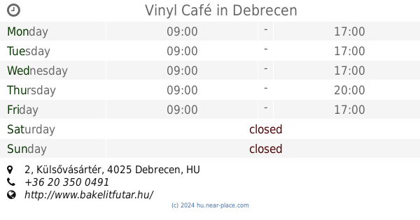
Vinyl Café
Debrecen, Külsővásártér 2
Cafe
read more
18.34 km
Cut & Coffee Debrecen
Debrecen, b, Hal köz 3
Cafe
read more
18.445 km
Menta coffee
Debrecen, 4025, Piac utca 17
Cafe
read more
18.454 km
Starbucks
Debrecen, Kossuth utca 1
Cafe
read more
18.512 km
Cafe Frei Debrecen Főtér
Debrecen, Piac utca 20
Cafe
read more
18.548 km
Devil's Cafe
Debrecen, Monostorpályi út 26./A
Cafe
read more
18.653 km
I-Bolt Glulu (Gluten-free)
Debrecen, Böszörményi út 138
Cafe
read more
18.805 km
Caffe Amici Gourmet Coffee
Debrecen, Péterfia utca 15
Cafe
read more
18.832 km
Latin Cafè
Debrecen, 4024, Csapó utca 28
Cafe
read more
18.858 km
Csekő Kávéház
Debrecen, Füredi út 25/b
Cafe
read more
19.576 km
Néro Caffe
Debrecen, Csillag utca 10
Cafe
read more
19.761 km
ÉTK Kávézó
Debrecen
Cafe
read more
19.871 km
Neon City & Garden
Debrecen, Kassai út 7
Cafe
read more
20.344 km
Popart Kávézó és Bár
Debrecen, Bihari utca 2
Cafe
read more
21.328 km
Starbucks
Debrecen, Csapó utca
Cafe
read more
25.727 km
Hajdúböszörményi Kávémanufaktúra
Hajdúböszörmény, Szabad hajdú utca 4
Cafe
read more
📑
all categories
Accounting
Administrative area level 1
Administrative area level 2
Airport
Amusement park
Aquarium
Art gallery
Atm
Bakery
Bank
Bar
Beauty salon
Bicycle store
Book store
Bowling alley
Bus station
Cafe
Campground
Car dealer
Car rental
Car repair
Car wash
Casino
Cemetery
Church
City hall
Clothing store
Colloquial area
Convenience store
Country
Courthouse
Dentist
Department store
Doctor
Electrician
Electronics store
Embassy
Finance
Fire station
Florist
Food
Funeral home
Furniture store
Gas station
General contractor
Grocery or supermarket
Gym
Hair care
Hardware store
Health
Hindu Temple
Home goods store
Hospital
Insurance agency
Intersection
Jewelry store
Laundry
Lawyer
Library
Light rail station
Liquor store
Local government office
Locality
Locksmith
Lodging
Meal delivery
Meal takeaway
Mosque
Movie rental
Movie theater
Moving company
Museum
Natural feature
Neighborhood
Night club
Painter
Park
Parking
Pet store
Pharmacy
Physiotherapist
Place of worship
Plumber
Point of interest
Police
Political
Post office
Premise
Real estate agency
Restaurant
Roofing contractor
Route
Rv park, camping
School
Shoe store
Shopping mall
Spa
Stadium
Storage
Store
Subpremise
Subway station
Supermarket
Synagogue
Taxi stand
Train station
Transit station
Travel agency
University
Veterinary care
Zoo
administrative area level 3
sublocality level 1
↑