Cafe nearby Hoppá Lángosos
Hungary
Cafe nearby Hoppá Lángosos
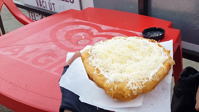
Hoppá Lángosos
Pilismarót, Rákóczi Ferenc utca 82 Magyarország
contacts phone
:
+36
Latitude:
47.7806259
, Longitude:
18.8843055
read more
nearest Cafe
2.461 km
Napfény Büfé
Dömös, Petőfi tér 8
Cafe
read more
2.461 km
Napfény Büfé, Fagyizó, Kávézó
Dömös, Petőfi tér 8
Cafe
read more
2.471 km
Napfény Büfé
Dömös, Petőfi tér 2
Cafe
read more
2.94 km
GALÉRIA CUKRÁSZDA
Zebegény, Petőfi tér 6
Cafe
read more
5.834 km
Rév Büfé
Nagymaros
Cafe
read more
7.119 km
Zsindelyes
Pilisszentkereszt, Eötvös Lóránd utca 10
Cafe
read more
9.576 km
Julius Meinl Kávézó
Esztergom, 2500, Felső-Kenderes dűlő 9-11
Cafe
read more
10.626 km
Café transformer
Esztergom, Vörösmarty utca
Cafe
read more
10.84 km
Cippolino Kávézó
Esztergom, Téglaház utca 1
Cafe
read more
10.877 km
All In Music Cafe
Esztergom, Bajcsy-Zsilinszky út 35
Cafe
read more
10.972 km
Danube Promenade Cafe
Esztergom, Kis Duna sétány 7
Cafe
read more
10.972 km
Dunakorzó Kávézó
Esztergom, Kis Duna sétány 7
Cafe
read more
11.004 km
GLS ESZTERGOM DEPÓ
Esztergom, Petz testvérek utca
Cafe
read more
11.433 km
Dzsámi Múzeum és Kávézó
Esztergom, Berényi Zsigmond utca 18
Cafe
read more
11.732 km
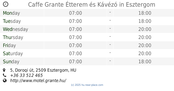
Caffe Grante Étterem és Kávézó
Esztergom, Dorogi út 5
Cafe
read more
12.135 km
Vén Duna Cukrászda
Verőce, Árpád út 36
Cafe
read more
12.283 km
Szántó Presszó
Ercsi, 6 6
Cafe
read more
13.149 km
Balay Club - Playhouse and Cafe
Dorog, Rákóczi Ferenc utca 5
Cafe
read more
13.425 km
Nagyírtáspuszta Kisvasút állomás
Nagybörzsöny
Cafe
read more
15.636 km
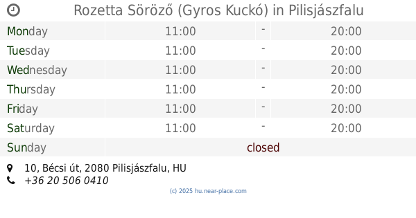
Rozetta Söröző (Gyros Kuckó)
Pilisjászfalu, Bécsi út 10
Cafe
read more
18.133 km
Caffé BonBon Csokoládébolt és Borárium
Pomáz, Tas utca 1
Cafe
read more
18.98 km
Tulipános Bolt
Szentendre, Alkotmány utca 3
Cafe
read more
19.004 km
Sandwiches-Coffe
Szentendre, Alkotmány utca 1-7
Cafe
read more
19.024 km
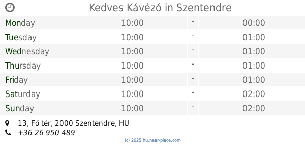
Kedves Kávézó
Szentendre, Fő tér 13
Cafe
read more
19.503 km
Kacsakő Bisztró
Szentendre, Szentendrei-Duna ág jobb part, 9+500 folyamkilométer 02/16 HRSZ
Cafe
read more
📑
all categories
Accounting
Administrative area level 1
Administrative area level 2
Airport
Amusement park
Aquarium
Art gallery
Atm
Bakery
Bank
Bar
Beauty salon
Bicycle store
Book store
Bowling alley
Bus station
Cafe
Campground
Car dealer
Car rental
Car repair
Car wash
Casino
Cemetery
Church
City hall
Clothing store
Colloquial area
Convenience store
Country
Courthouse
Dentist
Department store
Doctor
Electrician
Electronics store
Embassy
Finance
Fire station
Florist
Food
Funeral home
Furniture store
Gas station
General contractor
Grocery or supermarket
Gym
Hair care
Hardware store
Health
Hindu Temple
Home goods store
Hospital
Insurance agency
Intersection
Jewelry store
Laundry
Lawyer
Library
Light rail station
Liquor store
Local government office
Locality
Locksmith
Lodging
Meal delivery
Meal takeaway
Mosque
Movie rental
Movie theater
Moving company
Museum
Natural feature
Neighborhood
Night club
Painter
Park
Parking
Pet store
Pharmacy
Physiotherapist
Place of worship
Plumber
Point of interest
Police
Political
Post office
Premise
Real estate agency
Restaurant
Roofing contractor
Route
Rv park, camping
School
Shoe store
Shopping mall
Spa
Stadium
Storage
Store
Subpremise
Subway station
Supermarket
Synagogue
Taxi stand
Train station
Transit station
Travel agency
University
Veterinary care
Zoo
administrative area level 3
sublocality level 1
↑