Cafe nearby Familia Café
Coronavirus disease (COVID-19) Situation
confirmed cases
2230232
deaths
49048
Hungary
Cafe nearby Familia Café
Familia Café
Bicske, Szent István út 24 Magyarország
contacts phone
:
+36
Latitude:
47.4896079
, Longitude:
18.6330649
read more
nearest Cafe
400 m
Randevú Cukrászda
Bicske, Kossuth utca 8
Cafe
read more
897 m
Peter's Angels Spa & Café
Bicske, Kossuth utca 61/D
Cafe
read more
4.405 km
Gero Cafe
Csabdi, Béke utca 62
Cafe
read more
4.808 km
Mediterrán Kávéház
Felcsút, Fő utca 161
Cafe
read more
8.887 km
Dióhéj
Zsámbék, 5, Corvin János utca
Cafe
read more
8.965 km
Süti nem Süti
Zsámbék, Akadémia utca 8
Cafe
read more
9.025 km
DasCafè- a Kávézó és Gasztró Bisztró
Herceghalom, Gesztenyés út 45
Cafe
read more
9.445 km
Desszert Pince
Etyek, Újhegy
Cafe
read more
10.089 km
Etyeki Pizzéria (Rujp BT)
Etyek, Körpince köz 4
Cafe
read more
10.154 km
Café Madeleine
Etyek, Hősök tere 17
Cafe
read more
13.84 km
CSAKAFAGYI - látványfagyizó és cukrászda
Biatorbágy, Rosenbach János utca 57
Cafe
read more
14.287 km
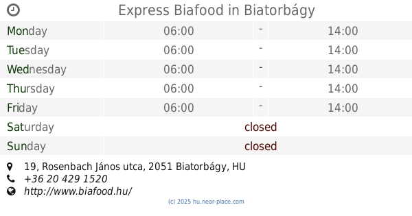
Express Biafood
Biatorbágy, Rosenbach János utca 19
Cafe
read more
14.442 km
Kettőspont Kávézó
Biatorbágy, Baross Gábor utca 3
Cafe
read more
14.442 km
Kürtöskalács és Kávézó
Biatorbágy, Baross Gábor utca 1
Cafe
read more
14.467 km
Kisvilla
Biatorbágy, Szabadság út 74
Cafe
read more
14.471 km
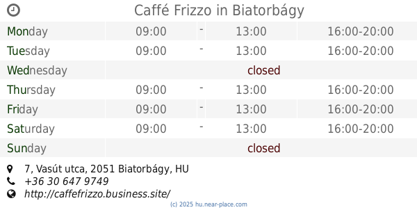
Caffé Frizzo
Biatorbágy, Vasút utca 7
Cafe
read more
14.517 km
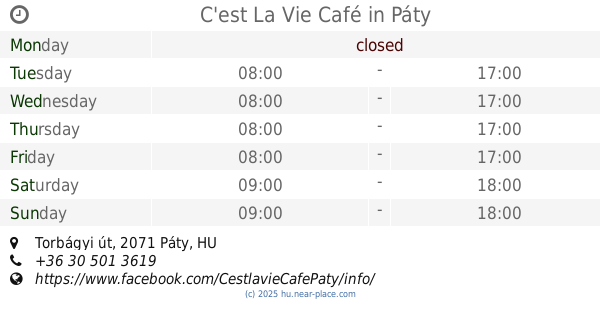
C'est La Vie Café
Páty, Torbágyi úti pincesor
Cafe
read more
14.524 km
C'est La Vie Café
Páty, Torbágyi út
Cafe
read more
14.607 km
Nemzeti Dohánybolt
Perbál, Fő utca
Cafe
read more
14.607 km
National tobacco shop
Perbál, Fő utca
Cafe
read more
14.784 km
Junior Kávéház
Budajenő, Kossuth Lajos utca 7
Cafe
read more
18.125 km
Tinnyei Teniszklub
Tinnye, Petőfi Sándor utca 40
Cafe
read more
21.624 km
Kati Néni Kocsmája
Piliscsaba, Fő út 96
Cafe
read more
22.505 km
Prosit Bar & Café
Budakeszi, Fő utca 147
Cafe
read more
25.134 km
ReBa kávézó
Pilisvörösvár, -32, Kisfaludy utca 30
Cafe
read more
📑
all categories
Accounting
Administrative area level 1
Administrative area level 2
Airport
Amusement park
Aquarium
Art gallery
Atm
Bakery
Bank
Bar
Beauty salon
Bicycle store
Book store
Bowling alley
Bus station
Cafe
Campground
Car dealer
Car rental
Car repair
Car wash
Casino
Cemetery
Church
City hall
Clothing store
Colloquial area
Convenience store
Country
Courthouse
Dentist
Department store
Doctor
Electrician
Electronics store
Embassy
Finance
Fire station
Florist
Food
Funeral home
Furniture store
Gas station
General contractor
Grocery or supermarket
Gym
Hair care
Hardware store
Health
Hindu Temple
Home goods store
Hospital
Insurance agency
Intersection
Jewelry store
Laundry
Lawyer
Library
Light rail station
Liquor store
Local government office
Locality
Locksmith
Lodging
Meal delivery
Meal takeaway
Mosque
Movie rental
Movie theater
Moving company
Museum
Natural feature
Neighborhood
Night club
Painter
Park
Parking
Pet store
Pharmacy
Physiotherapist
Place of worship
Plumber
Point of interest
Police
Political
Post office
Premise
Real estate agency
Restaurant
Roofing contractor
Route
Rv park, camping
School
Shoe store
Shopping mall
Spa
Stadium
Storage
Store
Subpremise
Subway station
Supermarket
Synagogue
Taxi stand
Train station
Transit station
Travel agency
University
Veterinary care
Zoo
administrative area level 3
sublocality level 1
↑