Cafe nearby Cserpes Tejivó
Coronavirus disease (COVID-19) Situation
confirmed cases
2230232
deaths
49048
Hungary
Cafe nearby Cserpes Tejivó
Cserpes Tejivó
Budapest, Corvin köz 1082 Magyarország
contacts phone
:
+36
Latitude:
47.4861815
, Longitude:
19.0707277
read more
nearest Cafe
2 m
UpTown Budapest
Budapest, Corvin köz 1
Cafe
read more
283 m
Cafe Frei
Budapest, Futó utca 37-45
Cafe
read more
298 m
Bubbleology
Budapest, Futó utca 37
Cafe
read more
301 m
Costa Coffee
Budapest, Futó utca 40
Cafe
read more
411 m
Kristály Cukrászda
Budapest, József körút 53
Cafe
read more
462 m
Hazai kézműves finomságok
Budapest, Tompa utca 26
Cafe
read more
526 m
Paris, Texas Kávéház
Budapest, Ráday utca 22
Cafe
read more
591 m
Tényleg Espresso Bar
Budapest, 39, Lónyay utca
Cafe
read more
667 m
Waffle & Love
Budapest, 1092, Ráday utca 1
Cafe
read more
723 m
Coffee Stand Gutenberg specialty coffeeshop
Budapest, Békési utca 1
Cafe
read more
761 m
Medicus Cafe
Budapest, Üllői út 89
Cafe
read more
774 m
Feher Holló Teaház
Budapest, Horánszky utca 1
Cafe
read more
778 m
Coffeeshop Company
Budapest, 3, Mátyás utca 1
Cafe
read more
778 m
Labrisz Office,
Budapest, Szentkiralyi ut 22, Szentkirályi utca 24
Cafe
read more
800 m
Sirius Teahaz
Budapest, Bródy Sándor utca 13
Cafe
read more
806 m
BeoPlay Budapest
Budapest, Fővám tér 11-12
Cafe
read more
873 m
Altair Teaház
Budapest, Puskin utca 24
Cafe
read more
923 m
Botanik Cafe
Budapest, Puskin utca 22
Cafe
read more
952 m
Café & Bar
Budapest, Mester utca 54
Cafe
read more
966 m
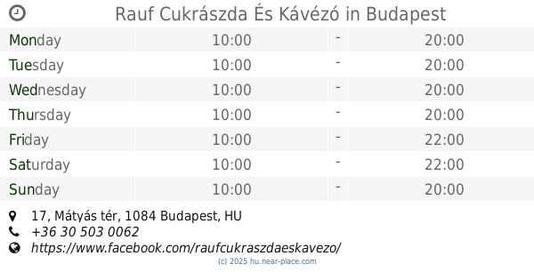
Rauf Cukrászda És Kávézó
Budapest, Mátyás tér 17
Cafe
read more
980 m
Doubleshot
Budapest, Veres Pálné utca 40
Cafe
read more
1.003 km
Konyha Bár
Budapest, Magyar utca
Cafe
read more
1.088 km
Zoska Reggeliző Kávézó
Budapest, Ferenczy István utca 28
Cafe
read more
1.272 km
Habroló
Budapest, Szép utca 1
Cafe
read more
1.291 km
Auguszt Cukrászda
Budapest, Kossuth Lajos utca 14-16.
Cafe
read more
📑
all categories
Accounting
Administrative area level 1
Administrative area level 2
Airport
Amusement park
Aquarium
Art gallery
Atm
Bakery
Bank
Bar
Beauty salon
Bicycle store
Book store
Bowling alley
Bus station
Cafe
Campground
Car dealer
Car rental
Car repair
Car wash
Casino
Cemetery
Church
City hall
Clothing store
Colloquial area
Convenience store
Country
Courthouse
Dentist
Department store
Doctor
Electrician
Electronics store
Embassy
Finance
Fire station
Florist
Food
Funeral home
Furniture store
Gas station
General contractor
Grocery or supermarket
Gym
Hair care
Hardware store
Health
Hindu Temple
Home goods store
Hospital
Insurance agency
Intersection
Jewelry store
Laundry
Lawyer
Library
Light rail station
Liquor store
Local government office
Locality
Locksmith
Lodging
Meal delivery
Meal takeaway
Mosque
Movie rental
Movie theater
Moving company
Museum
Natural feature
Neighborhood
Night club
Painter
Park
Parking
Pet store
Pharmacy
Physiotherapist
Place of worship
Plumber
Point of interest
Police
Political
Post office
Premise
Real estate agency
Restaurant
Roofing contractor
Route
Rv park, camping
School
Shoe store
Shopping mall
Spa
Stadium
Storage
Store
Subpremise
Subway station
Supermarket
Synagogue
Taxi stand
Train station
Transit station
Travel agency
University
Veterinary care
Zoo
administrative area level 3
sublocality level 1
↑