Cafe nearby Ceramicafe
Hungary
Cafe nearby Ceramicafe
Ceramicafe
Budapest, 21, em. 125-126, Ajtósi Dürer sor 19 Magyarország
contacts phone
:
+36
Latitude:
47.5097801
, Longitude:
19.0900369
read more
nearest Cafe
454 m
Nemzeti Dohánybolt NonStop
Budapest, Dózsa György út 29
Cafe
read more
477 m
Hermina Terasz Cafe & Grill
Budapest, Hermina út 17
Cafe
read more
523 m
Cukrászda -fagyizó
Budapest, Peterdy utca 40
Cafe
read more
618 m
Aranytölcsér Cukrászda-Kávéház
Budapest, Thököly út 44
Cafe
read more
621 m
BOHÉM coffee&wine
Budapest, Dózsa György út 5
Cafe
read more
621 m
BOHÉM coffee & wine Budapest
Budapest, Dózsa György út 5
Cafe
read more
629 m
Timi kávéja
Budapest, Sajó utca 2
Cafe
read more
639 m
La Lune Cafe
Budapest
Cafe
read more
641 m
Féltucat
Budapest, Ilka utca 25-27
Cafe
read more
654 m
Pasa Kebab Kft
Budapest, Istvánmezei út 2c
Cafe
read more
730 m
MKKP Kocsma
Budapest, Garay tér 9
Cafe
read more
750 m
Kürtőskalács Café
Budapest, Murányi utca 19
Cafe
read more
788 m
Café Frei Liget Centre
Budapest, Dózsa György út 84a
Cafe
read more
788 m
Café Frei
Budapest, Dózsa György út 84a
Cafe
read more
829 m
Teavolution Tea Room & Shop
Budapest, Dembinszky utca 32
Cafe
read more
839 m
Pawsome Budapest
Budapest, Damjanich utca 38
Cafe
read more
842 m
Cat Cafe
Budapest, Damjanich utca 38
Cafe
read more
893 m
Kapitány Cukrászda
Budapest, Damjanich utca 32
Cafe
read more
996 m
Mirage cafe
Budapest, Délibáb utca 35
Cafe
read more
1.017 km
Tipo & coffee
Budapest, Benczúr utca 36-38
Cafe
read more
1.036 km
Royal Park Boutique Hotel
Budapest, Nefelejcs utca 6
Cafe
read more
1.145 km
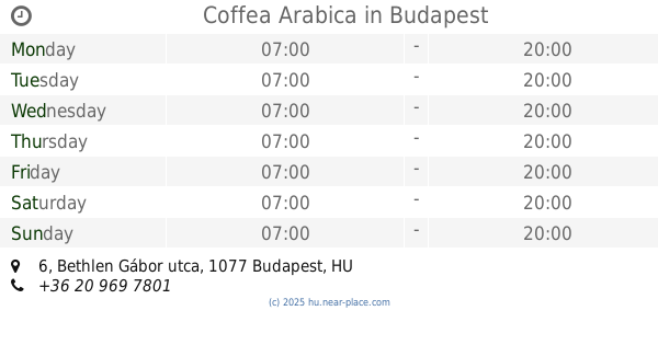
Coffea Arabica
Budapest, Bethlen Gábor utca 6
Cafe
read more
1.164 km
Lipóti Pékség és Kávézó
Budapest, Bethlen Gábor utca 4
Cafe
read more
1.196 km
The Goat Herder - Espresso Bar
Budapest, István utca 5
Cafe
read more
1.291 km
Algida
Budapest, Állatkerti körút 1
Cafe
read more
📑
all categories
Accounting
Administrative area level 1
Administrative area level 2
Airport
Amusement park
Aquarium
Art gallery
Atm
Bakery
Bank
Bar
Beauty salon
Bicycle store
Book store
Bowling alley
Bus station
Cafe
Campground
Car dealer
Car rental
Car repair
Car wash
Casino
Cemetery
Church
City hall
Clothing store
Colloquial area
Convenience store
Country
Courthouse
Dentist
Department store
Doctor
Electrician
Electronics store
Embassy
Finance
Fire station
Florist
Food
Funeral home
Furniture store
Gas station
General contractor
Grocery or supermarket
Gym
Hair care
Hardware store
Health
Hindu Temple
Home goods store
Hospital
Insurance agency
Intersection
Jewelry store
Laundry
Lawyer
Library
Light rail station
Liquor store
Local government office
Locality
Locksmith
Lodging
Meal delivery
Meal takeaway
Mosque
Movie rental
Movie theater
Moving company
Museum
Natural feature
Neighborhood
Night club
Painter
Park
Parking
Pet store
Pharmacy
Physiotherapist
Place of worship
Plumber
Point of interest
Police
Political
Post office
Premise
Real estate agency
Restaurant
Roofing contractor
Route
Rv park, camping
School
Shoe store
Shopping mall
Spa
Stadium
Storage
Store
Subpremise
Subway station
Supermarket
Synagogue
Taxi stand
Train station
Transit station
Travel agency
University
Veterinary care
Zoo
administrative area level 3
sublocality level 1
↑