Bar nearby Zsiga Bar
Coronavirus disease (COVID-19) Situation
confirmed cases
2230232
deaths
49048
Hungary
Bar nearby Zsiga Bar
Zsiga Bar
Budapest, -15 Hungary, Horváth Mihály tér 14 Węgry
contacts phone
:
+36
Latitude:
47.4901964
, Longitude:
19.0756025
read more
nearest Bar
176 m
Kis Práter Söröző
Budapest, Baross utca 82
Bar
read more
433 m
Andersen Pub
Budapest, Krúdy Gyula utca 17
Bar
read more
461 m
Neked csak Ny8lc
Budapest, b, Corvin sétány 2
Bar
read more
536 m
Cherry bár
Budapest, Népszínház utca 27
Bar
read more
794 m
Deus Sofőrszolgálat-a kéklámpás sofőrök
Budapest, Bródy Sándor utca 11-19
Bar
read more
839 m
Virus Cafe
Budapest, Ferenc körút 32
Bar
read more
856 m
Zero Bar
Budapest, 51,, Rákóczi út 49
Bar
read more
885 m
LINKUP - VR BAR
Budapest, Thaly Kálmán utca 45
Bar
read more
923 m
Mandarin Cafe
Budapest, Tompa utca 12
Bar
read more
927 m
No Name
Budapest, Tompa utca 8
Bar
read more
948 m
Kola Bistro & Bar
Budapest, Tompa utca 11
Bar
read more
995 m
Rombusz Terasz
Budapest, Ráday utca 10-12
Bar
read more
1.009 km
Ibis
Budapest, Ráday utca 6
Bar
read more
1.022 km
Bárka Borbár
Budapest, Dohány utca 68
Bar
read more
1.043 km
Prága Sörház
Budapest, Kertész utca 3
Bar
read more
1.071 km
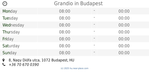
Grandio
Budapest, 1072, Nagy Diófa utca 8
Bar
read more
1.075 km
Központi Italkimérő
Budapest, 1088, Rákóczi út 11
Bar
read more
1.125 km
Füge Udvar
Budapest, Klauzál utca 19
Bar
read more
1.159 km
Lezser
Budapest, Lónyay utca 23
Bar
read more
1.161 km
Keret Café & Bar
Budapest, Síp utca 5
Bar
read more
1.19 km
Szimpla Kert
Budapest, Kazinczy utca 14
Bar
read more
1.208 km
Buborék Söröző
Budapest, Wesselényi utca 36
Bar
read more
1.241 km
Hops Beer Bar
Budapest, 1077, Wesselényi utca 13
Bar
read more
1.255 km
Chupito Bar - Shots & More
Budapest, 1077, Wesselényi utca 11
Bar
read more
1.285 km
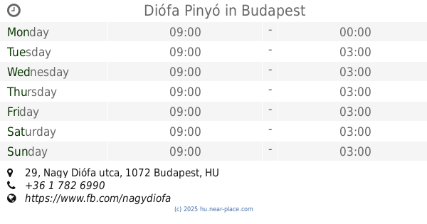
Diófa Pinyó
Budapest, Nagy Diófa utca 29
Bar
read more
📑
all categories
Accounting
Administrative area level 1
Administrative area level 2
Airport
Amusement park
Aquarium
Art gallery
Atm
Bakery
Bank
Bar
Beauty salon
Bicycle store
Book store
Bowling alley
Bus station
Cafe
Campground
Car dealer
Car rental
Car repair
Car wash
Casino
Cemetery
Church
City hall
Clothing store
Colloquial area
Convenience store
Country
Courthouse
Dentist
Department store
Doctor
Electrician
Electronics store
Embassy
Finance
Fire station
Florist
Food
Funeral home
Furniture store
Gas station
General contractor
Grocery or supermarket
Gym
Hair care
Hardware store
Health
Hindu Temple
Home goods store
Hospital
Insurance agency
Intersection
Jewelry store
Laundry
Lawyer
Library
Light rail station
Liquor store
Local government office
Locality
Locksmith
Lodging
Meal delivery
Meal takeaway
Mosque
Movie rental
Movie theater
Moving company
Museum
Natural feature
Neighborhood
Night club
Painter
Park
Parking
Pet store
Pharmacy
Physiotherapist
Place of worship
Plumber
Point of interest
Police
Political
Post office
Premise
Real estate agency
Restaurant
Roofing contractor
Route
Rv park, camping
School
Shoe store
Shopping mall
Spa
Stadium
Storage
Store
Subpremise
Subway station
Supermarket
Synagogue
Taxi stand
Train station
Transit station
Travel agency
University
Veterinary care
Zoo
administrative area level 3
sublocality level 1
↑