Bar nearby Sport presszó
Coronavirus disease (COVID-19) Situation
confirmed cases
2230232
deaths
49048
Hungary
Bar nearby Sport presszó
Sport presszó
Böhönye, Bethlen Gábor utca 49 Hungary
contacts phone
:
+36
Latitude:
46.4122828
, Longitude:
17.3923173
read more
nearest Bar
21.128 km
Nemzeti dohánybolt
Galambok, Somogyi Béla utca 1
Bar
read more
21.852 km
Italbolt
Csombárd, Kossuth Lajos utca 62
Bar
read more
24.243 km
National tobacco shop
Osztopán, Szabadság tér 7
Bar
read more
24.243 km
Nemzeti Dohánybolt
Osztopán, Szabadság tér 7
Bar
read more
27.29 km
Szent Orbán Panzió és Borozó - Étterem Zalakaros - kutyabarát szállás
Zalakaros, Szent Orbán út 12
Bar
read more
28.369 km
Nefelejcs Eszpresszó
Garabonc, Diós utca 2
Bar
read more
28.568 km
Márton presszó
Somogyvámos, Fő utca 78
Bar
read more
29.597 km
Nemzetközi Dohánybolt
Magyaregres, Vörös Hadsereg utca 1
Bar
read more
29.749 km
Víztorony Presszó
Nagykanizsa, Teleki utca
Bar
read more
30.729 km
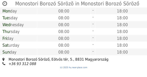
Monostori Borozó Sörözõ
Monostori Borozó Söröző, Eötvös tér, 5.
Bar
read more
30.898 km
Arany Hordó
Kaposvár, Zárda utca 14
Bar
read more
31.586 km
B&H Rock Pub
Kaposvár, Budai Nagy Antal utca
Bar
read more
37.904 km
Juice Terasz
Balatongyörök, Petőfi Sándor utca 1
Bar
read more
39.83 km
Sziget Café
Keszthely
Bar
read more
40.207 km
Pecás Büfé
Keszthely
Bar
read more
41.038 km
Cleopatra Bar Night Club
Keszthely, Rákóczi út 7
Bar
read more
42.025 km
Fenyő Presszó
Kisbárapáti, Fő utca 106
Bar
read more
42.986 km
Szabó Pince
Balatonederics, Újhegy
Bar
read more
44.99 km
Első Magyar Borház -Szeremley-birtok
Badacsonytomaj, -53, Fő utca 51
Bar
read more
46.32 km
Panoráma borozó
Hévíz, Dombföldi utca
Bar
read more
49.465 km
Kert Büfé
Káptalantóti, Badacsonyi utca 5
Bar
read more
53.035 km
Rio Snack Bar
Balatonszemes, Ady Endre utca 1
Bar
read more
53.052 km
Balatonszemes
Balatonszemes, Ady Endre utca 1
Bar
read more
62.801 km
Pilóta Presszó
Zalaegerszeg, Köztársaság útja 87
Bar
read more
64.584 km
O 'Connors Pub
Zalaegerszeg, Ola utca 16
Bar
read more
📑
all categories
Accounting
Administrative area level 1
Administrative area level 2
Airport
Amusement park
Aquarium
Art gallery
Atm
Bakery
Bank
Bar
Beauty salon
Bicycle store
Book store
Bowling alley
Bus station
Cafe
Campground
Car dealer
Car rental
Car repair
Car wash
Casino
Cemetery
Church
City hall
Clothing store
Colloquial area
Convenience store
Country
Courthouse
Dentist
Department store
Doctor
Electrician
Electronics store
Embassy
Finance
Fire station
Florist
Food
Funeral home
Furniture store
Gas station
General contractor
Grocery or supermarket
Gym
Hair care
Hardware store
Health
Hindu Temple
Home goods store
Hospital
Insurance agency
Intersection
Jewelry store
Laundry
Lawyer
Library
Light rail station
Liquor store
Local government office
Locality
Locksmith
Lodging
Meal delivery
Meal takeaway
Mosque
Movie rental
Movie theater
Moving company
Museum
Natural feature
Neighborhood
Night club
Painter
Park
Parking
Pet store
Pharmacy
Physiotherapist
Place of worship
Plumber
Point of interest
Police
Political
Post office
Premise
Real estate agency
Restaurant
Roofing contractor
Route
Rv park, camping
School
Shoe store
Shopping mall
Spa
Stadium
Storage
Store
Subpremise
Subway station
Supermarket
Synagogue
Taxi stand
Train station
Transit station
Travel agency
University
Veterinary care
Zoo
administrative area level 3
sublocality level 1
↑