Bar nearby Laci Bácsi Presszója
Coronavirus disease (COVID-19) Situation
confirmed cases
2230232
deaths
49048
Hungary
Bar nearby Laci Bácsi Presszója
Laci Bácsi Presszója
1, Virág utca, 2112, Veresegyház, HU Magyarország
contacts phone
:
+36
Latitude:
47.6496281
, Longitude:
19.2889849
larger map & directions
read more
nearest Bar
647 m
Nyárfás büfé
Veresegyház, Találkozók útja 1
Bar
read more
1.77 km
Príma Falatok
Veresegyház, Budapesti utca 1
Bar
read more
2.256 km
Star.bar
Erdőkertes
Bar
read more
2.921 km
M-Sky Nights Talk Corner
Erdőkertes, 2113, Vörösmarty utca 12
Bar
read more
5.636 km
Tó Büfé
Őrbottyán, Tó utca 7228
Bar
read more
6.901 km
Spíler Pub
Gödöllő, Bethlen Gábor utca 11
Bar
read more
11.299 km
Zámbó kocsma
Kistarcsa, Rákóczi körút 11
Bar
read more
11.914 km
Tükrös Presszó
Dunakeszi, a, Vasút utca 5
Bar
read more
12.275 km
Beugró söröző
Sződ, Árpád utca 2
Bar
read more
13.187 km
Zoli büfé
Szigetmonostor, Jácint utca 2
Bar
read more
14.538 km
promenade Bistro
Sződliget, 2133, Ország út 6
Bar
read more
14.814 km
Harmadik Félidő Pub
Budapest, Kordován tér 5
Bar
read more
15.097 km
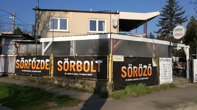
Synthesis Kézműves Söröző, Sörbolt
Budapest, Szlovák út 116
Bar
read more
15.16 km
Szerelmem
Bar
read more
16.271 km
Ámor Söröző
Budapest, Erdőkerülő utca 1
Bar
read more
16.365 km
Redwood Söröző
Budapest, János utca 106
Bar
read more
16.72 km
Páfrány Eszpresszó
Budapest, Csömöri út 139
Bar
read more
17.14 km
Club 501
Budapest, Drégelyvár utca 55
Bar
read more
17.644 km
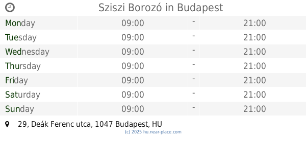
Sziszi Borozó
Budapest, Deák Ferenc utca 29
Bar
read more
17.808 km
Molo Cafe
Budapest, Szent István tér 14
Bar
read more
17.89 km
Fónagy és Walter Vendég- és Borház
Vác, Budapesti főút 36
Bar
read more
17.934 km
Fekete Lyuk Hangja Bt.
Budapest, Bonyhádi út 141
Bar
read more
18.013 km
Mackó Presszó
Vác, Damjanich János tér 15
Bar
read more
18.735 km
Duna Presszó
Vác, Március 15. tér 13
Bar
read more
19.909 km
Pietro Sport Pub
Budapest, Nagy Lajos király útja 193
Bar
read more
📑
all categories
Accounting
Administrative area level 1
Administrative area level 2
Airport
Amusement park
Aquarium
Art gallery
Atm
Bakery
Bank
Bar
Beauty salon
Bicycle store
Book store
Bowling alley
Bus station
Cafe
Campground
Car dealer
Car rental
Car repair
Car wash
Casino
Cemetery
Church
City hall
Clothing store
Colloquial area
Convenience store
Country
Courthouse
Dentist
Department store
Doctor
Electrician
Electronics store
Embassy
Finance
Fire station
Florist
Food
Funeral home
Furniture store
Gas station
General contractor
Grocery or supermarket
Gym
Hair care
Hardware store
Health
Hindu Temple
Home goods store
Hospital
Insurance agency
Intersection
Jewelry store
Laundry
Lawyer
Library
Light rail station
Liquor store
Local government office
Locality
Locksmith
Lodging
Meal delivery
Meal takeaway
Mosque
Movie rental
Movie theater
Moving company
Museum
Natural feature
Neighborhood
Night club
Painter
Park
Parking
Pet store
Pharmacy
Physiotherapist
Place of worship
Plumber
Point of interest
Police
Political
Post office
Premise
Real estate agency
Restaurant
Roofing contractor
Route
Rv park, camping
School
Shoe store
Shopping mall
Spa
Stadium
Storage
Store
Subpremise
Subway station
Supermarket
Synagogue
Taxi stand
Train station
Transit station
Travel agency
University
Veterinary care
Zoo
administrative area level 3
sublocality level 1
↑