Bar nearby Kisbetyár Vendéglő
Coronavirus disease (COVID-19) Situation
confirmed cases
2230232
deaths
49048
Hungary
Bar nearby Kisbetyár Vendéglő
Kisbetyár Vendéglő
Kömpöc, Petőfi Sándor utca 4 Hungary
contacts phone
:
+36
Latitude:
46.4645183
, Longitude:
19.8691234
read more
nearest Bar
11.379 km
Juhász kocsma
Balástya, Őszeszék tanya 56
Bar
read more
11.381 km
Fecskefészek Büfé
Forráskút, Csongrádi utca 1-3
Bar
read more
11.549 km
Csöpi Büfé
Forráskút, Felszabadulás utca 49
Bar
read more
16.896 km
Astor Söröző
Bordány, Dudás utca 61
Bar
read more
21.268 km
Búfelejtő Kocsma
Kiskunfélegyháza, Selymes 2. dűlő
Bar
read more
27.153 km
Piros Rózsa Italbolt
Domaszék
Bar
read more
28.295 km
rose Parlor
Szeged, Csallóközi utca
Bar
read more
30.612 km
Flört Presszó
Szeged, Gáspár Zoltán utca
Bar
read more
30.756 km
Tyukász Bt.
Szeged, Algyői út 27
Bar
read more
30.764 km
Tyúkász Kocsma
Szeged, Algyői út 27
Bar
read more
30.843 km
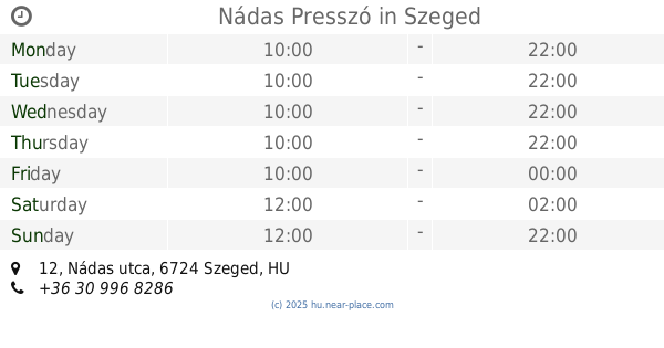
Nádas Presszó
Szeged, Nádas utca 12
Bar
read more
31.008 km
HB Söröző
Szeged, Csongrádi sugárút 48
Bar
read more
31.403 km
Vico Drink Bar
Szeged, Szent István tér 16
Bar
read more
31.596 km
Jeges Kocsma
Szeged, Tisza Lajos körút 53
Bar
read more
31.599 km
Vegas Biliárd Pub
Szeged, Budapesti körút 5
Bar
read more
31.613 km
Szegedi Jégkunyhó Kft.
Szeged, Tisza Lajos körút 53
Bar
read more
31.621 km
Zöld Tündér Abszint Bár és Kávézó
Szeged, Tisza Lajos körút 57
Bar
read more
31.651 km
Kálvária Bár
Szeged, Kálvária sugárút 10
Bar
read more
31.844 km
Fülig Jimmy Pub
Szeged, József Attila sugárút 13
Bar
read more
31.92 km
Piano Pub
Szeged, Kölcsey utca 4
Bar
read more
31.923 km
Zápor József kávézója
Szeged, Deák Ferenc utca 15
Bar
read more
32.098 km
Sze(k)szkazán
Szeged, Szentháromság utca 77
Bar
read more
32.312 km
Mátyás Söröző
Szeged, Apáca utca 28
Bar
read more
33.011 km
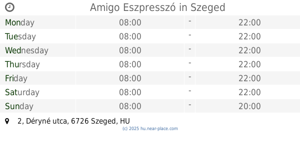
Amigo Eszpresszó
Szeged, Déryné utca 2
Bar
read more
33.221 km
Teve Kocsma
Szeged, Horgony utca 3
Bar
read more
📑
all categories
Accounting
Administrative area level 1
Administrative area level 2
Airport
Amusement park
Aquarium
Art gallery
Atm
Bakery
Bank
Bar
Beauty salon
Bicycle store
Book store
Bowling alley
Bus station
Cafe
Campground
Car dealer
Car rental
Car repair
Car wash
Casino
Cemetery
Church
City hall
Clothing store
Colloquial area
Convenience store
Country
Courthouse
Dentist
Department store
Doctor
Electrician
Electronics store
Embassy
Finance
Fire station
Florist
Food
Funeral home
Furniture store
Gas station
General contractor
Grocery or supermarket
Gym
Hair care
Hardware store
Health
Hindu Temple
Home goods store
Hospital
Insurance agency
Intersection
Jewelry store
Laundry
Lawyer
Library
Light rail station
Liquor store
Local government office
Locality
Locksmith
Lodging
Meal delivery
Meal takeaway
Mosque
Movie rental
Movie theater
Moving company
Museum
Natural feature
Neighborhood
Night club
Painter
Park
Parking
Pet store
Pharmacy
Physiotherapist
Place of worship
Plumber
Point of interest
Police
Political
Post office
Premise
Real estate agency
Restaurant
Roofing contractor
Route
Rv park, camping
School
Shoe store
Shopping mall
Spa
Stadium
Storage
Store
Subpremise
Subway station
Supermarket
Synagogue
Taxi stand
Train station
Transit station
Travel agency
University
Veterinary care
Zoo
administrative area level 3
sublocality level 1
↑