Bar nearby Borbarát Borozó
Coronavirus disease (COVID-19) Situation
confirmed cases
2230232
deaths
49048
Hungary
Bar nearby Borbarát Borozó
Borbarát Borozó
2, Váci út, 1132, Budapest, HU Magyarország
contacts phone
:
+36
Latitude:
47.5107172
, Longitude:
19.055588
larger map & directions
read more
nearest Bar
133 m
Bierbar günstig Budapest
Budapest, Bihari János utca 20
Bar
read more
136 m
St. Andrea Wine & Gourmet Bar
Budapest, Bajcsy-Zsilinszky út 78
Bar
read more
203 m
A Maci
Budapest, Jókai utca 36
Bar
read more
317 m
Trocadero Cafe
Budapest, Szent István körút 15
Bar
read more
456 m
Cafe Vogue Pub
Budapest, Teréz körút 41
Bar
read more
523 m
Star Inn Hotel Budapest Centrum, by Comfort
Budapest, Dessewffy utca 36
Bar
read more
547 m
Pointer Pub - Teréz Krt.
Budapest, Teréz körút 34
Bar
read more
555 m
Tokai Borozó
Budapest, Falk Miksa utca 32
Bar
read more
567 m
Epa söröző
Budapest, Visegrádi utca 32-34
Bar
read more
596 m
ALTEREGO
Budapest, Dessewffy utca 33
Bar
read more
610 m
BARhole
Budapest, Jókai utca 8
Bar
read more
612 m
Cheers Pub
Budapest, Nagymező utca 35
Bar
read more
696 m
Roma Club Budapest
Budapest, Nagymező utca 40
Bar
read more
703 m
Piaf Bar & Disco
Budapest, Nagymező utca 25
Bar
read more
703 m
Piaf
Budapest, Nagymező utca 25
Bar
read more
725 m
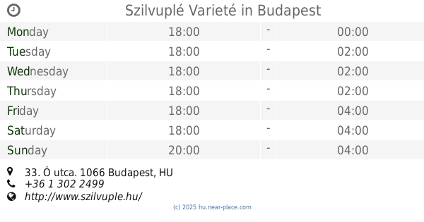
Szilvuplé Varieté
Budapest, Ó utca 33
Bar
read more
742 m
Matin club
Bem József utca 2
Bar
read more
800 m
Mornys Pub Coffee
Budapest, Jókai tér 3
Bar
read more
801 m
Game Up Pub!
Budapest, Zichy Jenő utca 4
Bar
read more
810 m
A Másik Ajtó (The Other Door)
Budapest, Pozsonyi út 41
Bar
read more
873 m
Poppy & Eve Gastro Pub
Budapest, Podmaniczky Frigyes tér 4
Bar
read more
951 m
Jazzy Pub
Budapest, Liszt Ferenc tér 10
Bar
read more
994 m
Captain Cook Pub
Budapest, Bajcsy-Zsilinszky út 19/a
Bar
read more
1.06 km
Little Horn Tavern Winery
Budapest, Bulcsú utca 23a
Bar
read more
1.113 km
Kiraly Club
Budapest, Király utca 70
Bar
read more
📑
all categories
Accounting
Administrative area level 1
Administrative area level 2
Airport
Amusement park
Aquarium
Art gallery
Atm
Bakery
Bank
Bar
Beauty salon
Bicycle store
Book store
Bowling alley
Bus station
Cafe
Campground
Car dealer
Car rental
Car repair
Car wash
Casino
Cemetery
Church
City hall
Clothing store
Colloquial area
Convenience store
Country
Courthouse
Dentist
Department store
Doctor
Electrician
Electronics store
Embassy
Finance
Fire station
Florist
Food
Funeral home
Furniture store
Gas station
General contractor
Grocery or supermarket
Gym
Hair care
Hardware store
Health
Hindu Temple
Home goods store
Hospital
Insurance agency
Intersection
Jewelry store
Laundry
Lawyer
Library
Light rail station
Liquor store
Local government office
Locality
Locksmith
Lodging
Meal delivery
Meal takeaway
Mosque
Movie rental
Movie theater
Moving company
Museum
Natural feature
Neighborhood
Night club
Painter
Park
Parking
Pet store
Pharmacy
Physiotherapist
Place of worship
Plumber
Point of interest
Police
Political
Post office
Premise
Real estate agency
Restaurant
Roofing contractor
Route
Rv park, camping
School
Shoe store
Shopping mall
Spa
Stadium
Storage
Store
Subpremise
Subway station
Supermarket
Synagogue
Taxi stand
Train station
Transit station
Travel agency
University
Veterinary care
Zoo
administrative area level 3
sublocality level 1
↑