Bar nearby Arany Szőlő
Coronavirus disease (COVID-19) Situation
confirmed cases
2230232
deaths
49048
Hungary
Bar nearby Arany Szőlő
Arany Szőlő
Eger, Csiky Sándor utca 35 Magyarország
contacts phone
:
+36
Latitude:
47.903315
, Longitude:
20.3664409
read more
nearest Bar
243 m
Két pisztoly söröző
Eger, Sertekapu utca 6
Bar
read more
379 m
Fusion Bar and Cellar Winery
Eger, Csiky Sándor utca 10
Bar
read more
379 m
Fúzió Pincebár és Pincészet
Eger, Csiky Sándor utca 10
Bar
read more
515 m
Betűz Söröző
Eger, Széchenyi István utca 41
Bar
read more
547 m
Artiszt
Eger, Kepes Központ, Széchenyi István utca 16
Bar
read more
621 m
Dragon Darts Pub
Eger, Vörösmarty Mihály utca 23
Bar
read more
634 m
Csiga Ház
Eger, Széchenyi István utca 4
Bar
read more
715 m
Imbisz Borozó
Eger, Gárdonyi Géza tér
Bar
read more
743 m
The Hangover House
Eger, Eszterházy tér 1
Bar
read more
771 m
The Duck - Wine Bar
Eger, Arany János utca 3
Bar
read more
771 m
Kacsa Borozó
Eger, Arany János utca 3
Bar
read more
798 m
Corner2 Gasztro Pub
Eger, Bajcsy-Zsilinszky Endre 4
Bar
read more
800 m
Zöld Pecsét Kávézó és Borbár
Eger, Király utca 8
Bar
read more
821 m
Wine Vision Club
Eger, Jókai Mór utca 10
Bar
read more
852 m
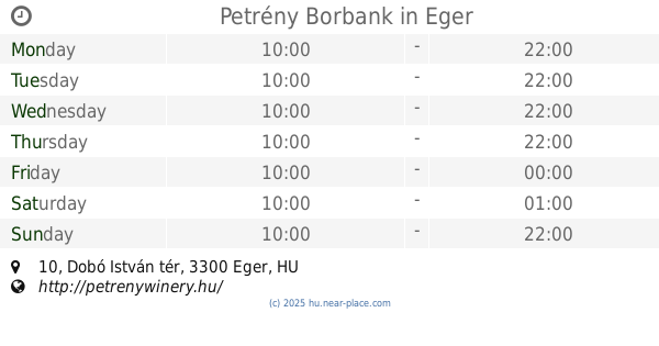
Petrény Borbank
Eger, Dobó István tér 10
Bar
read more
1.035 km
London Bar & Darts Club
Eger, Szálloda utca 1-3
Bar
read more
1.254 km
Putyi pub
Eger, Szarvas tér 2
Bar
read more
1.528 km
Hagymási Pince
Eger, Szépasszonyvölgy 19.
Bar
read more
1.552 km
Sarok Borozó
Eger, 48-as pince, 2416
Bar
read more
1.568 km
Szent Vince Winery
Eger, 28-as pince, Szépasszonyvölgy
Bar
read more
1.574 km
Stars of Eger Zrt. Basement
Eger, 30-as pince, Szépasszonyvölgy
Bar
read more
1.574 km
Egri Csillagok Zrt. Pince
Eger, 30-as pince, Szépasszonyvölgy
Bar
read more
1.575 km
Szépasszonyvölgy 46
Eger, Szépasszonyvölgy 46
Bar
read more
1.581 km
Termelői borkimérés
Eger, Szépasszonyvölgy 30
Bar
read more
1.898 km
Fakocsma
Eger, Cifrakapu utca 150-152
Bar
read more
📑
all categories
Accounting
Administrative area level 1
Administrative area level 2
Airport
Amusement park
Aquarium
Art gallery
Atm
Bakery
Bank
Bar
Beauty salon
Bicycle store
Book store
Bowling alley
Bus station
Cafe
Campground
Car dealer
Car rental
Car repair
Car wash
Casino
Cemetery
Church
City hall
Clothing store
Colloquial area
Convenience store
Country
Courthouse
Dentist
Department store
Doctor
Electrician
Electronics store
Embassy
Finance
Fire station
Florist
Food
Funeral home
Furniture store
Gas station
General contractor
Grocery or supermarket
Gym
Hair care
Hardware store
Health
Hindu Temple
Home goods store
Hospital
Insurance agency
Intersection
Jewelry store
Laundry
Lawyer
Library
Light rail station
Liquor store
Local government office
Locality
Locksmith
Lodging
Meal delivery
Meal takeaway
Mosque
Movie rental
Movie theater
Moving company
Museum
Natural feature
Neighborhood
Night club
Painter
Park
Parking
Pet store
Pharmacy
Physiotherapist
Place of worship
Plumber
Point of interest
Police
Political
Post office
Premise
Real estate agency
Restaurant
Roofing contractor
Route
Rv park, camping
School
Shoe store
Shopping mall
Spa
Stadium
Storage
Store
Subpremise
Subway station
Supermarket
Synagogue
Taxi stand
Train station
Transit station
Travel agency
University
Veterinary care
Zoo
administrative area level 3
sublocality level 1
↑