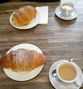
Bakery nearby Pipacs Pékség
Hungary
Bakery nearby Pipacs Pékség
Pipacs Pékség
267, Bécsi út, 1037, Budapest, HU Węgry
contacts phone
:
+36 70 429 8964
website:
www.pipacspekseg.hu
Latitude:
47.550557
, Longitude:
19.0306739
larger map & directions
read more
nearest Bakery
140 m
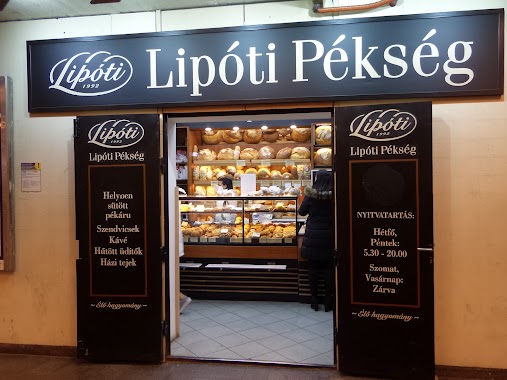
Lipóti pékség és kávézó
Budapest, Bécsi út 265
Bakery
read more
163 m
Martini Bakery
Budapest, Vörösvári út 137
Bakery
read more
475 m
Kex Aprósütemény (Eurocenter)
Budapest, Bécsi út 154
Bakery
read more
586 m
Koch-Danica Cukrászda Kft. Esküvői Torta Rendelés, Sütemény Rendelés, Torta Rendelés Budapest
Budapest, Vörösvári út 41
Bakery
read more
682 m
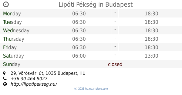
Lipóti Pékség
Budapest, Vörösvári út 29
Bakery
read more
955 m
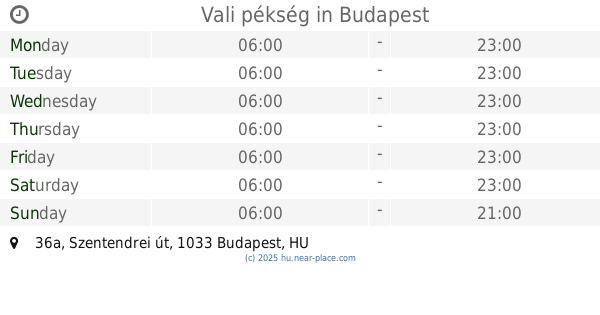
Vali pékség
Budapest, Szentendrei út 36a
Bakery
read more
959 m
Lehmann Pékség
Budapest, Kórház utca 37-41
Bakery
read more
1.191 km
Telepi Pékség
Budapest, Szérűskert utca 37
Bakery
read more
1.25 km
Fornetti Látványpékség
Budapest, Miklós utca 3
Bakery
read more
1.251 km
Pékség
Budapest, Apát utca
Bakery
read more
1.259 km
Kabasi Pékség
Budapest, Szőlő utca 68
Bakery
read more
1.63 km
Sarki Pékség
Budapest, Selmeci utca 19
Bakery
read more
1.698 km
Fornetti pékség
Budapest, Szentlélek tér
Bakery
read more
1.719 km
Confectionery Cserfalvi
Budapest, Bécsi út 270
Bakery
read more
1.731 km
Culinaris Buda
Budapest, Perc utca 8
Bakery
read more
1.99 km
Bonit'Art Sütikompánia
Budapest, Pacsirtamező utca 13
Bakery
read more
2.103 km
Pékesség
Budapest, Lajos utca 93-99
Bakery
read more
2.283 km
JÓkenyér
Budapest, Szépvölgyi út 63
Bakery
read more
2.445 km
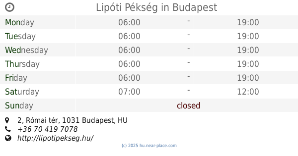
Lipóti Pékség
Budapest, Római tér 2
Bakery
read more
2.517 km
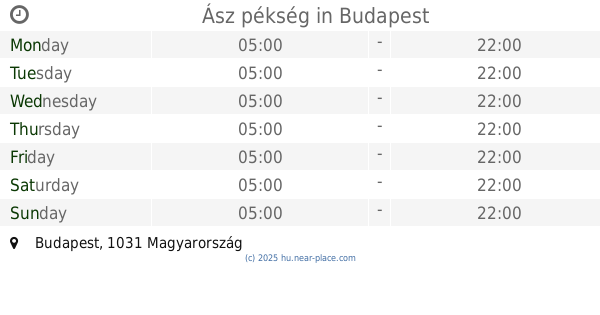
Ász pékség
Budapest
Bakery
read more
2.931 km
Pékség és Gyros
Budapest, Vizafogó sétány 10
Bakery
read more
3.246 km
Csocsaj Pékség
Budapest, Viza utca 11
Bakery
read more
3.369 km
Lipóti Bakery
Budapest, Váci út 71
Bakery
read more
3.554 km
Numan Pékség
Budapest, Pannónia utca 91
Bakery
read more
3.72 km
BAKERY (Idriz Extra ltd.)
Budapest, Kassák Lajos utca 70
Bakery
read more
📑
all categories
Accounting
Administrative area level 1
Administrative area level 2
Airport
Amusement park
Aquarium
Art gallery
Atm
Bakery
Bank
Bar
Beauty salon
Bicycle store
Book store
Bowling alley
Bus station
Cafe
Campground
Car dealer
Car rental
Car repair
Car wash
Casino
Cemetery
Church
City hall
Clothing store
Colloquial area
Convenience store
Country
Courthouse
Dentist
Department store
Doctor
Electrician
Electronics store
Embassy
Finance
Fire station
Florist
Food
Funeral home
Furniture store
Gas station
General contractor
Grocery or supermarket
Gym
Hair care
Hardware store
Health
Hindu Temple
Home goods store
Hospital
Insurance agency
Intersection
Jewelry store
Laundry
Lawyer
Library
Light rail station
Liquor store
Local government office
Locality
Locksmith
Lodging
Meal delivery
Meal takeaway
Mosque
Movie rental
Movie theater
Moving company
Museum
Natural feature
Neighborhood
Night club
Painter
Park
Parking
Pet store
Pharmacy
Physiotherapist
Place of worship
Plumber
Point of interest
Police
Political
Post office
Premise
Real estate agency
Restaurant
Roofing contractor
Route
Rv park, camping
School
Shoe store
Shopping mall
Spa
Stadium
Storage
Store
Subpremise
Subway station
Supermarket
Synagogue
Taxi stand
Train station
Transit station
Travel agency
University
Veterinary care
Zoo
administrative area level 3
sublocality level 1
↑