Bakery nearby Pékház Mintabolt
Coronavirus disease (COVID-19) Situation
confirmed cases
2230232
deaths
49048
Hungary
Bakery nearby Pékház Mintabolt
Pékház Mintabolt
10, Petőfi tér, 4025, Debrecen, HU Hungría
contacts phone
:
+36
website:
pekhaz.hu
Latitude:
47.5215143
, Longitude:
21.6267944
larger map & directions
read more
nearest Bakery
272 m
Európa Pékség
Debrecen, Petőfi tér 4
Bakery
read more
612 m
PÉKHÁZ Mintabolt
Debrecen, Szent Anna utca 10-12
Bakery
read more
612 m
Pékház - Pékház Kft.
Debrecen, Szent Anna utca 10
Bakery
read more
623 m
Kiscipó Pékség
Debrecen, Sumen utca 18
Bakery
read more
785 m
Sütisziget
Debrecen, Külsővásártér 7
Bakery
read more
815 m
PÉKHÁZ Mintabolt
Debrecen, Széchenyi utca 52-56
Bakery
read more
859 m
Verona bakery
Debrecen, Batthyány utca 2
Bakery
read more
926 m
Rétesbolt
Debrecen, Piac utca 23
Bakery
read more
1.032 km
Szivárvány Pékség
Debrecen, Kossuth utca 45
Bakery
read more
1.084 km
French Bakery
Debrecen, Csapó utca 15
Bakery
read more
1.131 km
PÉKHÁZ Mintabolt
Debrecen, Hatvan utca 12-14
Bakery
read more
1.17 km
Update Bakery
Debrecen, Csapó utca 25
Bakery
read more
1.242 km
PÉKHÁZ Mintabolt
Debrecen, Vár utca 3
Bakery
read more
1.37 km
Balmaz Sütöde
Debrecen, Segner János tér 7/A
Bakery
read more
1.501 km
Diti Bakery
Debrecen, Csapó utca 64
Bakery
read more
1.501 km
DITI Pékség
Debrecen, Csapó utca 64
Bakery
read more
1.502 km
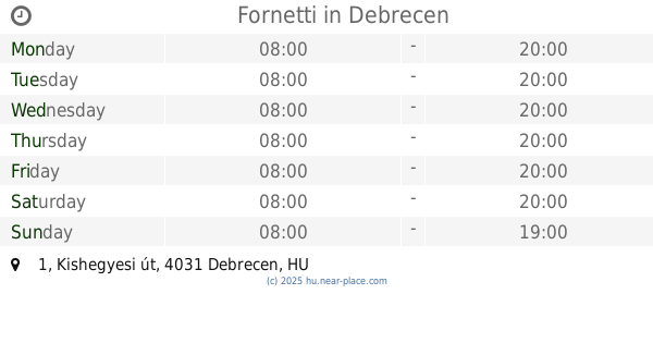
Fornetti
Debrecen, Péterfia utca 20
Bakery
read more
1.636 km
Fornetti
Debrecen, Kishegyesi út 1
Bakery
read more
1.683 km
Buci pékség
Debrecen, Víztorony utca
Bakery
read more
1.709 km
Lejla Bakery
Debrecen, Darabos utca 18
Bakery
read more
1.709 km
Lejla Pékség
Debrecen, Darabos utca 18
Bakery
read more
1.756 km
Pékáru Balmaz Sütöde Kft.
Debrecen, Csapó utca 90
Bakery
read more
1.832 km
Pékház Kft.
Debrecen, Dárda utca 13
Bakery
read more
1.947 km
Balmaz - Sütöde Kft. Pékáru
Debrecen, Ibolya utca 4
Bakery
read more
2.028 km
Lejla Pékség
Debrecen, Ótemető utca 29
Bakery
read more
📑
all categories
Accounting
Administrative area level 1
Administrative area level 2
Airport
Amusement park
Aquarium
Art gallery
Atm
Bakery
Bank
Bar
Beauty salon
Bicycle store
Book store
Bowling alley
Bus station
Cafe
Campground
Car dealer
Car rental
Car repair
Car wash
Casino
Cemetery
Church
City hall
Clothing store
Colloquial area
Convenience store
Country
Courthouse
Dentist
Department store
Doctor
Electrician
Electronics store
Embassy
Finance
Fire station
Florist
Food
Funeral home
Furniture store
Gas station
General contractor
Grocery or supermarket
Gym
Hair care
Hardware store
Health
Hindu Temple
Home goods store
Hospital
Insurance agency
Intersection
Jewelry store
Laundry
Lawyer
Library
Light rail station
Liquor store
Local government office
Locality
Locksmith
Lodging
Meal delivery
Meal takeaway
Mosque
Movie rental
Movie theater
Moving company
Museum
Natural feature
Neighborhood
Night club
Painter
Park
Parking
Pet store
Pharmacy
Physiotherapist
Place of worship
Plumber
Point of interest
Police
Political
Post office
Premise
Real estate agency
Restaurant
Roofing contractor
Route
Rv park, camping
School
Shoe store
Shopping mall
Spa
Stadium
Storage
Store
Subpremise
Subway station
Supermarket
Synagogue
Taxi stand
Train station
Transit station
Travel agency
University
Veterinary care
Zoo
administrative area level 3
sublocality level 1
↑