Bakery nearby Lipóti Pékség
Coronavirus disease (COVID-19) Situation
confirmed cases
2230232
deaths
49048
Hungary
Bakery nearby Lipóti Pékség
Lipóti Pékség
Nagyvárad tér, 1089, Budapest, HU Magyarország
contacts phone
:
+36 20 243 6051
website:
lipotipekseg.hu
Latitude:
47.4790964
, Longitude:
19.0892937
larger map & directions
read more
nearest Bakery
357 m
EDI & NESI PÉKSÉG
Budapest
Bakery
read more
676 m
Kerekerdő Sütöde
Budapest, 1098, Márton utca 18
Bakery
read more
815 m
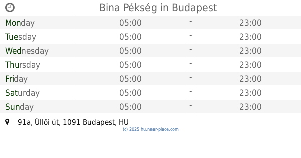
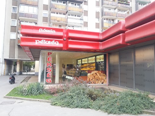
Bina Pékség
Budapest, Üllői út 91a
Bakery
read more
817 m
Lipóti Pékség
Budapest, Üllői út -Könyves Kálmán krt
Bakery
read more
817 m
Lipóti Bakery
Budapest, Üllői út -Könyves Kálmán krt
Bakery
read more
880 m
Fornetti
Budapest, Üllői út 131
Bakery
read more
924 m
Friss Finom Pékség
Budapest, Kőris utca 37
Bakery
read more
1.084 km
Lipóti Pégség
Budapest, Könyves Kálmán körút 12-14.
Bakery
read more
1.132 km
Florián Pékség
Budapest, Szigony utca 12
Bakery
read more
1.165 km
Besjana pékség
Budapest, Kálvária tér 18
Bakery
read more
1.195 km
Tina Pékség
Budapest, Mester utca 40
Bakery
read more
1.333 km
Lipóti pékség
Budapest, Haller utca 12
Bakery
read more
1.393 km
Lipóti pékség
Budapest, Mester utca 24
Bakery
read more
1.401 km
Félegyházi Pékség
Budapest, Tompa utca 15b
Bakery
read more
1.452 km
Flórián Pékség
Budapest, Baross utca 77
Bakery
read more
1.55 km
Látványpékség
Budapest, Tűzoltó utca 4
Bakery
read more
1.563 km
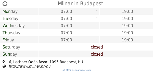
Mlinar
Budapest, Lechner Ödön fasor 6
Bakery
read more
1.666 km
Fornetti
Budapest, József körút 87
Bakery
read more
1.697 km
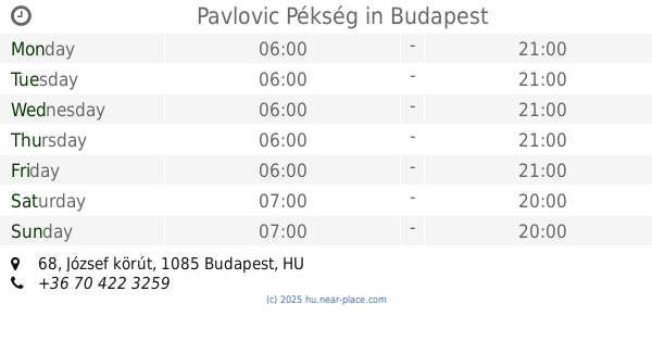
Pavlovic Pékség
Budapest, József körút 68
Bakery
read more
1.883 km
Lipóti pékség
Budapest, Ecseri út 2
Bakery
read more
1.952 km
Lipóldi Pékség
Budapest, Rákóczi tér 7-9
Bakery
read more
1.962 km
Hoppácska
Budapest, Ráday utca 33
Bakery
read more
2.222 km
Budapest Cukrászda
Budapest, Bródy Sándor utca 23/a
Bakery
read more
2.223 km
Budapest Bakery & Cafe
Budapest, Üllői út 9
Bakery
read more
2.412 km
Lipóti Pékség
Budapest, Blaha Lujza tér 1
Bakery
read more
📑
all categories
Accounting
Administrative area level 1
Administrative area level 2
Airport
Amusement park
Aquarium
Art gallery
Atm
Bakery
Bank
Bar
Beauty salon
Bicycle store
Book store
Bowling alley
Bus station
Cafe
Campground
Car dealer
Car rental
Car repair
Car wash
Casino
Cemetery
Church
City hall
Clothing store
Colloquial area
Convenience store
Country
Courthouse
Dentist
Department store
Doctor
Electrician
Electronics store
Embassy
Finance
Fire station
Florist
Food
Funeral home
Furniture store
Gas station
General contractor
Grocery or supermarket
Gym
Hair care
Hardware store
Health
Hindu Temple
Home goods store
Hospital
Insurance agency
Intersection
Jewelry store
Laundry
Lawyer
Library
Light rail station
Liquor store
Local government office
Locality
Locksmith
Lodging
Meal delivery
Meal takeaway
Mosque
Movie rental
Movie theater
Moving company
Museum
Natural feature
Neighborhood
Night club
Painter
Park
Parking
Pet store
Pharmacy
Physiotherapist
Place of worship
Plumber
Point of interest
Police
Political
Post office
Premise
Real estate agency
Restaurant
Roofing contractor
Route
Rv park, camping
School
Shoe store
Shopping mall
Spa
Stadium
Storage
Store
Subpremise
Subway station
Supermarket
Synagogue
Taxi stand
Train station
Transit station
Travel agency
University
Veterinary care
Zoo
administrative area level 3
sublocality level 1
↑